ORH_wxman
-
Posts
90,902 -
Joined
-
Last visited
Content Type
Profiles
Blogs
Forums
American Weather
Media Demo
Store
Gallery
Everything posted by ORH_wxman
-
March 12/13/14 Blizzard/Winter Storm/WWA etc
ORH_wxman replied to Bostonseminole's topic in New England
That is def an ugly sucker hole over CT....it prob won't last all morning though
-
March 12/13/14 Blizzard/Winter Storm/WWA etc
ORH_wxman replied to Bostonseminole's topic in New England
Yep...clear jack is gonna be interior SE MA...even a little off the water down near PYM is gonna be included. Like Carver up to Bridgewater. Crushed. There will be some secondary higher ratio fluff jacks to the west, but the real crushing snow is going to be roughly BOS-PVD and southeast I think. -
March 12/13/14 Blizzard/Winter Storm/WWA etc
ORH_wxman replied to Bostonseminole's topic in New England
I missed that, lol -
March 12/13/14 Blizzard/Winter Storm/WWA etc
ORH_wxman replied to Bostonseminole's topic in New England
KPYM 131335Z AUTO 01032G46KT M1/4SM FG VV004 01/00 A2938 RMK AO2 PK WND 01046/1332 SNEMMB25SNEMM TSB03E18 P0002 I1003 T00110000 PWINO FZRANO $ Impressive PYM ob...if you aren't familiar with them, the airport is actually kind of depressed in a bad wind spot, so G46 there is solid. Also like the M1/4 vis. -
March 12/13/14 Blizzard/Winter Storm/WWA etc
ORH_wxman replied to Bostonseminole's topic in New England
Western band is sliding east while the eastern stuff is still pushing NW....might see a pretty sick pivot band where the two meet up...or maybe new stuff forms too.
-
March 12/13/14 Blizzard/Winter Storm/WWA etc
ORH_wxman replied to Bostonseminole's topic in New England
temps have really crashed in the past hour...lots of 30-31F readings now in metrowest. ORH down to 27F. Snow is def going to dry out some. -
March 12/13/14 Blizzard/Winter Storm/WWA etc
ORH_wxman replied to Bostonseminole's topic in New England
Some serious banding setting up right now in metrowest
-
March 12/13/14 Blizzard/Winter Storm/WWA etc
ORH_wxman replied to Bostonseminole's topic in New England
Interior SE MA jack incoming. -
March 12/13/14 Blizzard/Winter Storm/WWA etc
ORH_wxman replied to Bostonseminole's topic in New England
Power outages. -
March 12/13/14 Blizzard/Winter Storm/WWA etc
ORH_wxman replied to Bostonseminole's topic in New England
Looks like we're trying to accelerate some dewpoint drain down the Maine and NH coasts too. That should help cool things a bit as the storm progresses (as well as the natural latent cooling of heavy snow at 34). Logan airport is down to 32..might slip another degree or two as well. -
March 12/13/14 Blizzard/Winter Storm/WWA etc
ORH_wxman replied to Bostonseminole's topic in New England
What's wrong with the HRRR? Looks like a crushing. -
86-87 was def a really good winter just off the coast. Esp Jan 87. But those teasers (or blockbuster for a small area, lol) in November were a good prelude. Just a nitpick though...it wasn't really a "bowling ball". It was a very strong vortmax moving through southern lakes that went nuclear when it go south of LI. A classic clipper/redeveloper as we sometimes call them on here...a rarity to see one so perfect in November though like that year.
-
Surprised PWM has only had one occurrence at the modern jetport site. I assume the 1923 and earlier occurrences were all at the older site. The jetport is obviously right on the water, but it is still a pretty decent snow spot. I would have thought at least a couple times more recently. Winters like '92-'93 or '95-'96....surprised they didn't squeak one out in '68-'69.
-
Oh yeah, it's totally greedy....but if you were here to see the model forecasts and the hype, you would have been certain that 30" was the floor...esp in a place like ORH that benefits from the easterly flow. OBviously I'd know better now having been watching this stuff an additional 15 years, but the model outputs were that impressive.
-
The Dover area was actually pretty close to ground zero in the big Mar 2001 storm...they had close to 40 inches. I also remember being "disappointed" in ORH with "only" about 24" in that storm. I was thinking 30" minimum.
-
Feb 5, 2001 was def the most painful event for the coast that winter...I think it's a lot worse than Dec 30, 2000 since even over the interior in 12/30/00, we got dryslotted and it was not a monster. But Feb 5 was 18-30 inches over the interior. Coast got porked. Though for some, the sting of getting basically zero in Dec 2000 might be worse. Feb 5 at least did give 5-8" around BOS at the end.
-
Was that the Mar 22-23, 2001 storm? That was a paste bomb (though prob turned into a denser powder later on) up in Maine...I think Eustis had like 34 inches from it.
-
I def wouldn't forecast a monster storm based on that ETA run down in the M.A....maybe for like NNJ still, but that is getting pretty ugly for the rest of the M.A.....relying on just the deformation which it wasn't uncommon for the ETA to be overdone on (the QPF bias back then was even more than now on the ETA...aka NAM). You can actually see how much central and S NJ is dryslotted too. But that run def gave a little more snow to the M.A. than I recalled in the 2011 synopsis...maybe I need to do some more mind exercises. lol.
-
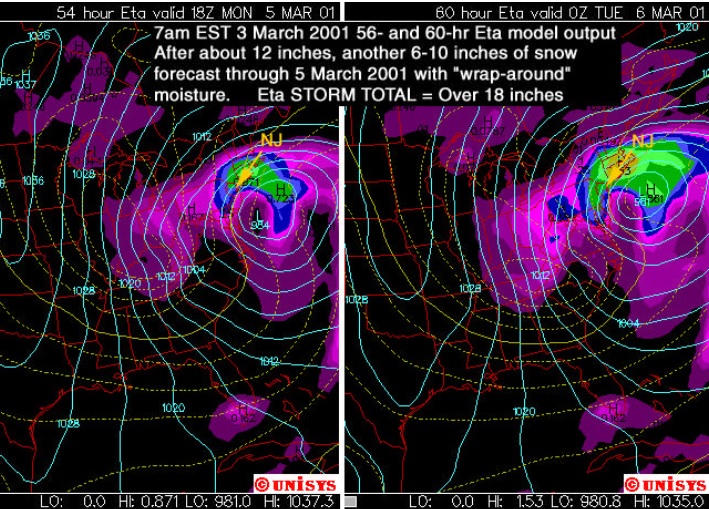
2 more from March 2001...model images....first one is the AVN model and the 2nd one is the ETA model from a Rutgers presentation I believe (hence the focus on NJ)...you can see by the 12z run Saturday morning, the ETA was already crushing SNE...though it was still overdone for the mid-atlantic, but the trend was in full effect by this point (the ETA-X was actually more aggressive in the next panel or two).....you can see how ridiculously far south of AVN is....these are not the same model run...AVN is 12 hours earlier in the cycle, but it's still way south in classic KU position for the M.A.:
-
12/30/00 kind of sucked in ORH too...not because we changed to rain, but because we got blitzed for several hours and then a horrific dryslot that went all the way into S VT, which effectively ended the storm. It never really gave much as it collapsed back east, maybe another inch of currier and ives snow. The forecast for for widespread 10-16" or so...but most were in the 6-10 range...with a few lucky 12" lollis. I thought 10" was unlucky at first but then found out I was actually fortunate to get that much. The first 4-5 hours were pretty fun though...very heavy snow. I'm sure it was a great storm for the greens.
-
Radarman sold his camera to ginxy a few years later.
-
I had to drive back to ORH twice that semester from Cornell...once right before the March 2001 blizzard to see my sister's college recital (she went to Boston Conservatory of music)...experiencing the storm was fun at least (and I felt bad because there was like a crowd of 20 people around me during the reception asking about the storm...at this point the forecast was literally 30-40" for a lot of MA)...and then again in early April around the 10th...there was still about 10-12" of snow on the ground the 2nd time. It was bizarre in that it wasn't the typical "fresh snow pack on April 10th from a big storm on April 7th" type pack you would normally see that late. It was clearly layered snowpack and looked more like mid March than April 10th. It definitely would have been a horror show for golfers ready to get out and start the season.
-
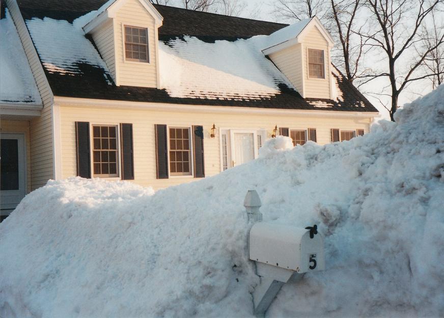
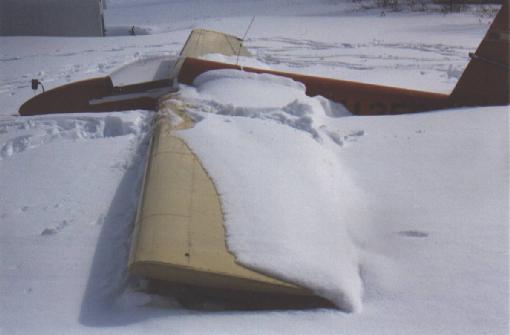
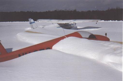
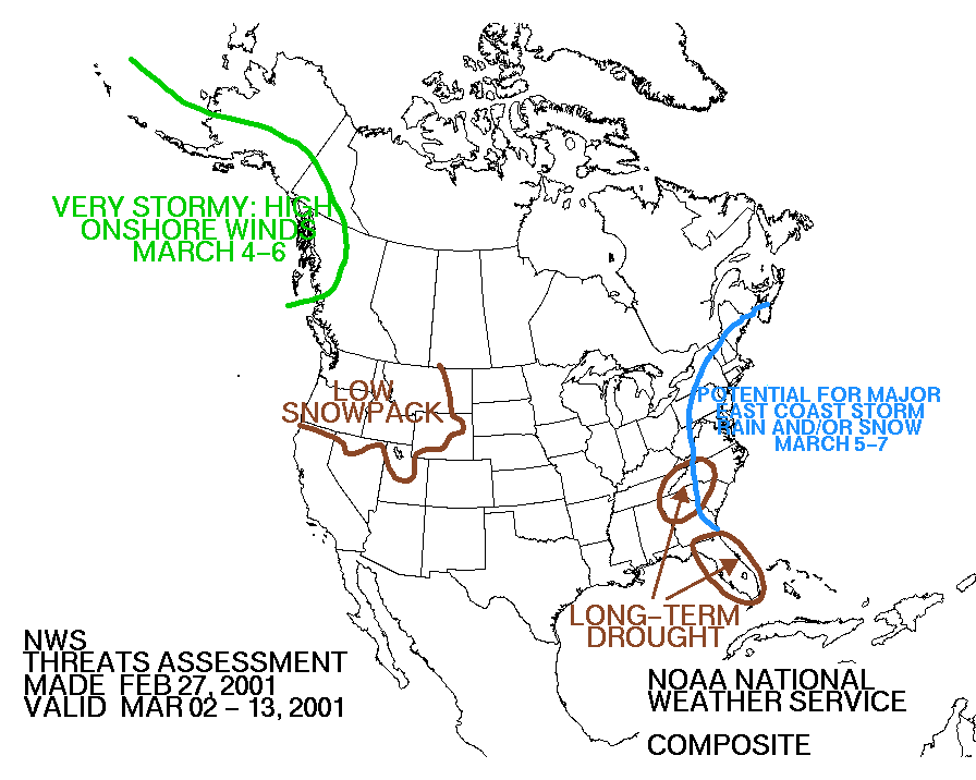
Some old March 2001 stuff...the airplanes are Sterling, MA airport that I remember grabbing online not too long after the storm...and there's a late February map from HPC on the threat:
-
It was def a huge bust by a lot of big name outlets. I think it would be unlikely to happen again because we have better ECMWF data now and it also runs twice a day. Back then, we only got one run of the Euro per day and it was crappy graphics and the one run (12z) didn't even come out until 7-8pm. The Euro was not gung ho on huge mid-atlanitc snows once we got inside of about 72 hours...it was even iffy at 96 hours. When it trended way north into a New England storm at 72 hours...I recall DT on ne.weather saying it was completely over for the M.A....citing the EE rule...the old ETAx (which was the ETA out to 84 ours) had a similar solution. I think way too much weight was probably placed on the GFS (AVN model back then), UKMET, and Canadian around 48-72 hours...and it was probably because there was much better access to that data and it was more timely. Also the AVN had been performing well that winter, so folks didn't have a huge reason to doubt it again....except for the fact that the ECMWF was against it.
-
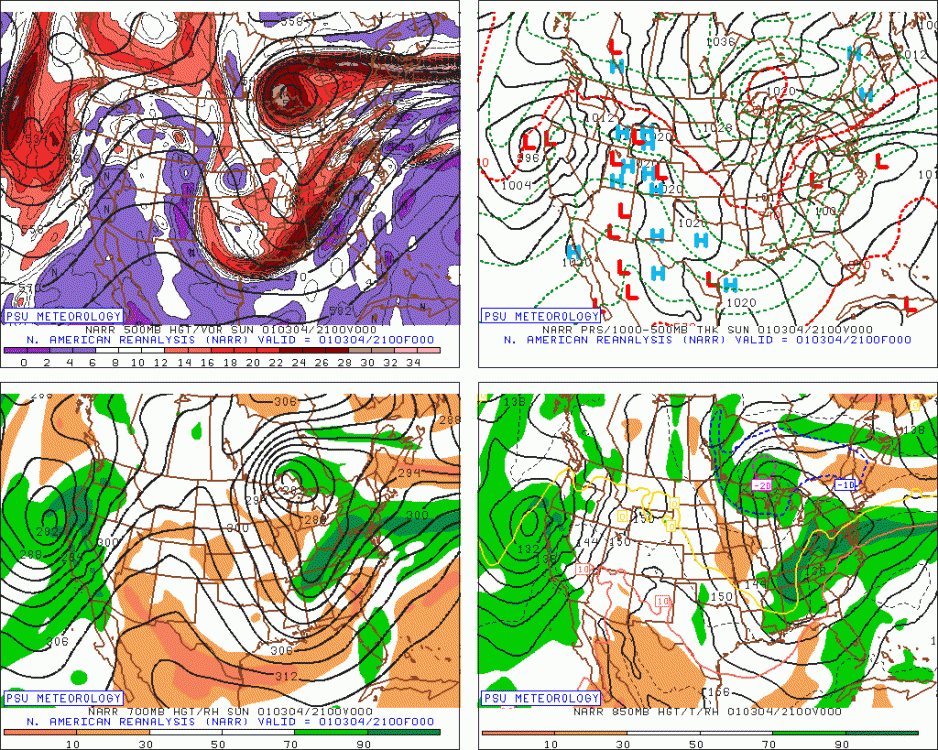
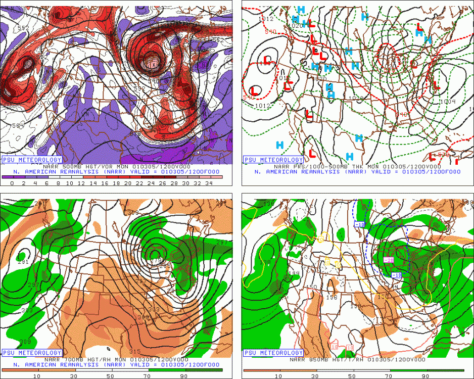
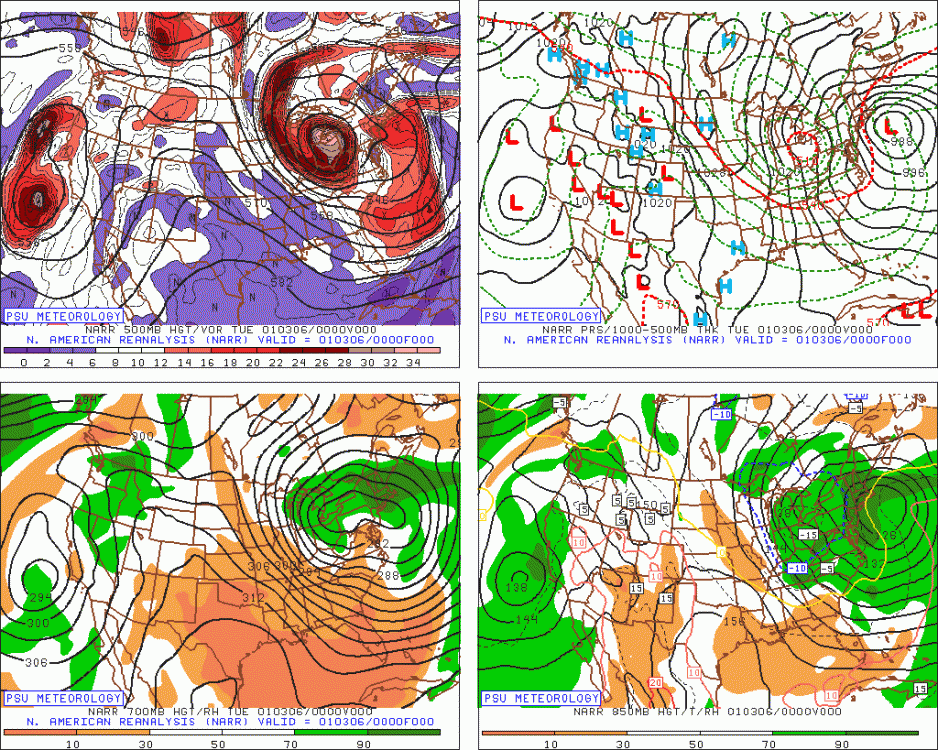
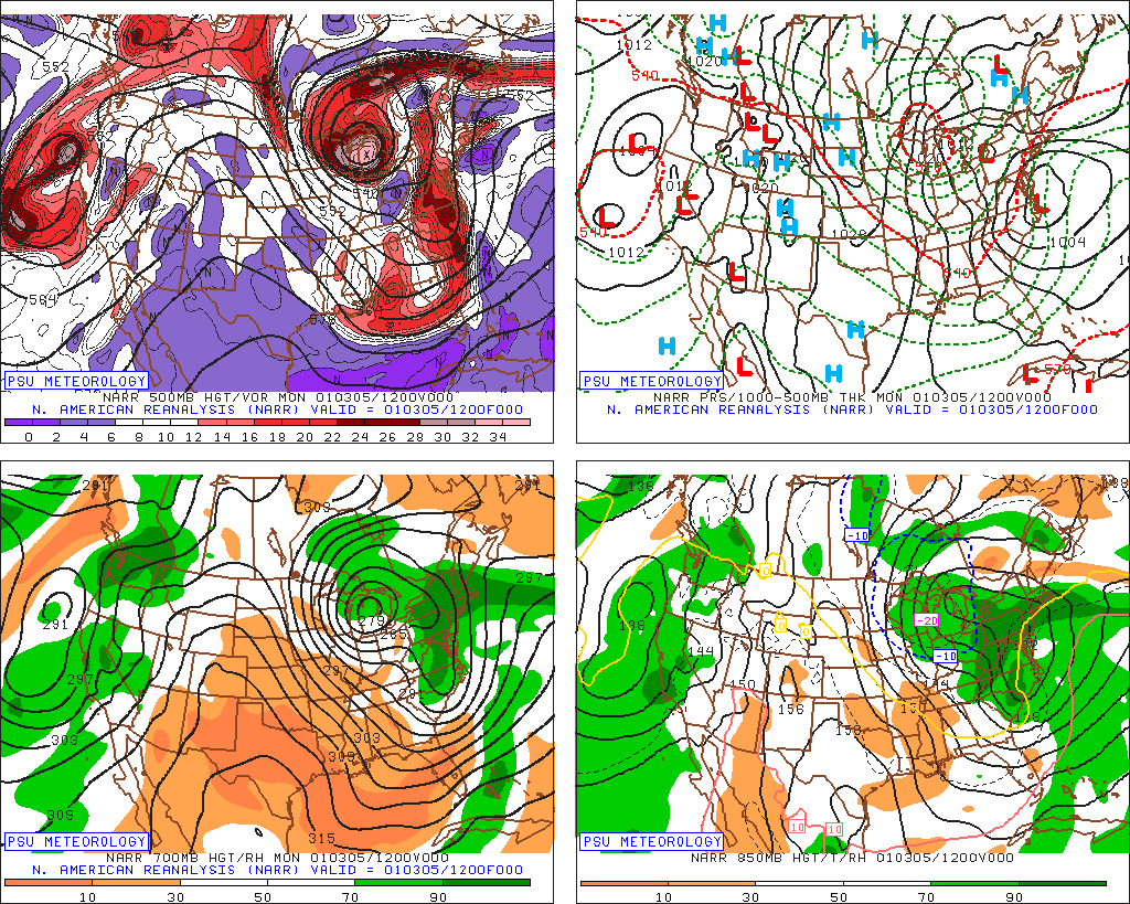
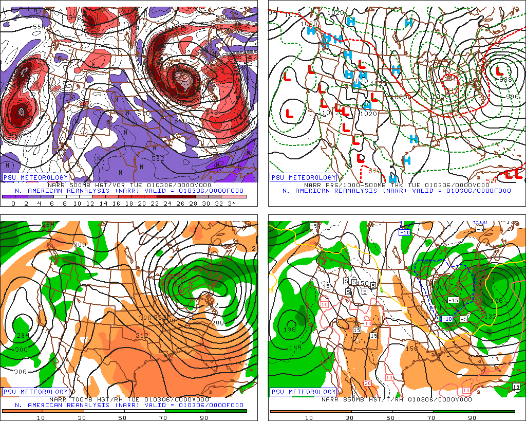
If that initial spoke of energy out to the east of the main 500 low in the lakes hadn't been there, then it would have been a much better storm further south...but the whole baroclinic zone set up along that spoke, so you had to be pretty far north where the spoke was to get max snowfall. The whole thing eventually congeals further south....but again, by the time that happens, the storm is occluding, so the dynamics have weakened somewhat. So your area prob had like 8-12" instead of 18-24. You'll often hear that the storm "didn't phase cleanly" and that's what is really mean by that....that leading piece of energy kind of outran the main 500 low just a little bit. Here's a view of that energy when it's further south still...you can see it's over MS/AL down south...things are looking good....but by the time we get to the next morning, it's starting to outrun the lakes 500 low a little too much and you can see the 850mb front is already over LI (look at the kinks poking east in the isoheights) and the storm isn't really organized yet...finally, the sequence reaches Tuesday evening and that's the plot I showed once already above where the storm is finally starting to really organize well and the 700 low is trying to redevelop, but at this point, it's pretty far north, so you're missing out on the best initial frontogenesis...you still end up getting decent snow eventually as everything congeals south/southeast, but you probably cost yourself at least 10 inches with the missed opportunity early in the storm...that was intense ML fronto snow: