

ORH_wxman
-
Posts
90,902 -
Joined
-
Last visited
Content Type
Profiles
Blogs
Forums
American Weather
Media Demo
Store
Gallery
Everything posted by ORH_wxman
-
March 12/13/14 Blizzard/Winter Storm/WWA etc
ORH_wxman replied to Bostonseminole's topic in New England
Yeah every once in awhile Norfolk will get like a 6 inch blitz on upslope and you're like "WTF did that come from?" while its partly sunny 10-15 miles east. -
March 12/13/14 Blizzard/Winter Storm/WWA etc
ORH_wxman replied to Bostonseminole's topic in New England
Towns that have their own local power company seem to fair way better than the larger companies in avoiding outages or getting power back much faster when they do occur. -
March 12/13/14 Blizzard/Winter Storm/WWA etc
ORH_wxman replied to Bostonseminole's topic in New England
The type of snow in that death band was blower...like LES almost. 20 to 1 or 25 to 1 stuff. So the swipers and the "yardstick in the ground at the end" measurements are going to have more disparity than usual. If the snow had much crappier ratios, then the differences would be pretty minor. -
March 12/13/14 Blizzard/Winter Storm/WWA etc
ORH_wxman replied to Bostonseminole's topic in New England
I know Sam mentioned the squalls tomorrow afternoon, but don't sleep on a bit of snow too in the evening/night as well tomorrow night with the deepening of the ULL just as it passes our longitude, almost wants to throw an IVT back, so there could be some currier and ives stuff that blossoms. Doubt it will be a big deal, but if someone gets an inch or so it wouldn't be shocking. -
March 12/13/14 Blizzard/Winter Storm/WWA etc
ORH_wxman replied to Bostonseminole's topic in New England
You can update measurements however frequently you'd like, but you can't wipe the board clean more than once every 6 hours. When you wipe the board, you must take note of the depth on the board before you clean it. -
March 12/13/14 Blizzard/Winter Storm/WWA etc
ORH_wxman replied to Bostonseminole's topic in New England
Yeah that was the winter....2009-2010. It still gives a lot of people PTSD about a -NAO despite what happened the next winter with a strong -NAO....then 2013 and now this March. Ill say to wiz, confluence isn't a bad thing. It's only bad when it's so strong we get whiffed. But confluence helps with frontogenesis so you can wring out extra precip too...and on would-be rainers, it can force them underneath us for snow instead. -
March 12/13/14 Blizzard/Winter Storm/WWA etc
ORH_wxman replied to Bostonseminole's topic in New England
Yeah it was all about the midlevels. Same theme (different setup though) in march 2013 with the surface low way east but the midlevels were throwing forcing wayyy west into SNE. -
March 12/13/14 Blizzard/Winter Storm/WWA etc
ORH_wxman replied to Bostonseminole's topic in New England
About 2 feet in Holliston...finally cleared out deck and driveway and ready to go on a drive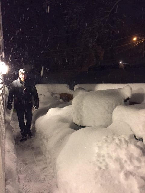
-
March 12/13/14 Blizzard/Winter Storm/WWA etc
ORH_wxman replied to Bostonseminole's topic in New England
Band is slowly moving east....but another slow moving band over ORH is migrating as well.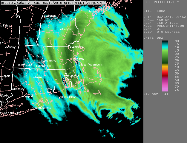
-
March 12/13/14 Blizzard/Winter Storm/WWA etc
ORH_wxman replied to Bostonseminole's topic in New England
Yes...you can see it happening out by ORH now...but that is good for eastern folks to try and kep the party going into after hours -
March 12/13/14 Blizzard/Winter Storm/WWA etc
ORH_wxman replied to Bostonseminole's topic in New England
There's even good bands regenerating over ORH county right now...that ML forcing dies hard. It's still taking its time leaving as much mentioned above. -
March 12/13/14 Blizzard/Winter Storm/WWA etc
ORH_wxman replied to Bostonseminole's topic in New England
It'll get you...there's really good F-GEN at 700-500 over E MA right now. That means the forcing is still strong so the bands should continue to generate as they slowly crawl eastward. -
March 12/13/14 Blizzard/Winter Storm/WWA etc
ORH_wxman replied to Bostonseminole's topic in New England
Time for BOS to cash in now...looks like its finally getting there. That 128-495 zone just continues to get nuked -
March 12/13/14 Blizzard/Winter Storm/WWA etc
ORH_wxman replied to Bostonseminole's topic in New England
You'll get in on it soon...the 700-500 F-GEN looks solid over E MA right now...so I wouldn't expect a lot of weakening over the next couple hours. -
March 12/13/14 Blizzard/Winter Storm/WWA etc
ORH_wxman replied to Bostonseminole's topic in New England
495-128 band is just rotting and absolutely destroying a good chunk of interior E MA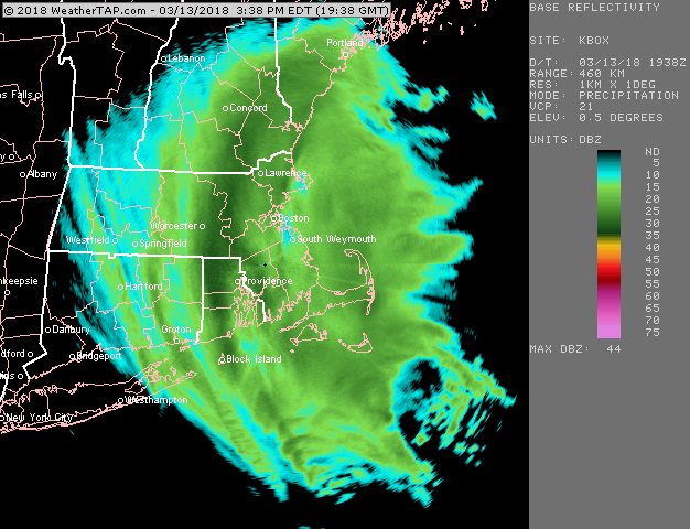
-
March 12/13/14 Blizzard/Winter Storm/WWA etc
ORH_wxman replied to Bostonseminole's topic in New England
495 band has temporarily stalled again...you can see the west edge bulging back.
-
March 12/13/14 Blizzard/Winter Storm/WWA etc
ORH_wxman replied to Bostonseminole's topic in New England
Yeah there's gonna be some 20-burgers in N RI. -
March 12/13/14 Blizzard/Winter Storm/WWA etc
ORH_wxman replied to Bostonseminole's topic in New England
This helps make up for March 2013 in RI: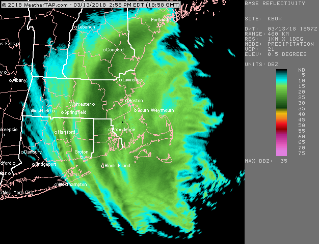
-
March 12/13/14 Blizzard/Winter Storm/WWA etc
ORH_wxman replied to Bostonseminole's topic in New England
Jack is gonna be SE ORH county to NW RI I think...ORH up through 495 northeast will be pretty close, but prob a bit less. But we'll see....that 495 band is just absolutely puking flakes and it's moving pretty slow.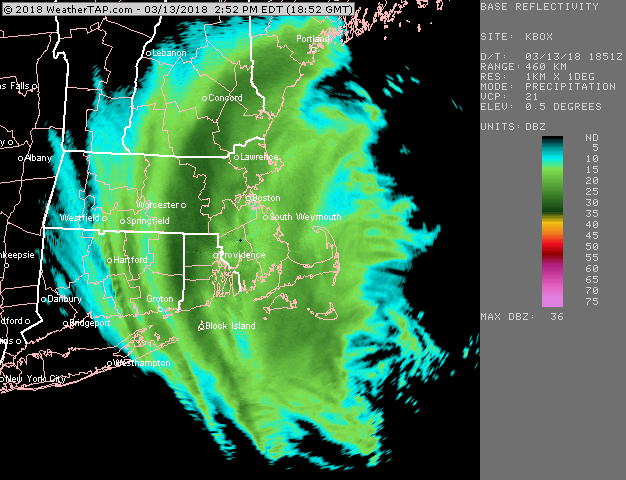
-
March 12/13/14 Blizzard/Winter Storm/WWA etc
ORH_wxman replied to Bostonseminole's topic in New England
It wouldn't surprise me if there were an inch or two tonight from that. The ULL goes right over head too which will help with the snow shower activity. -
March 12/13/14 Blizzard/Winter Storm/WWA etc
ORH_wxman replied to Bostonseminole's topic in New England
There's still solid 700-500 frontogenesis occurring over E MA, so the bands will likely produce for the next several hours. -
March 12/13/14 Blizzard/Winter Storm/WWA etc
ORH_wxman replied to Bostonseminole's topic in New England
Big time snows for 495 to ORH right now. And N RI.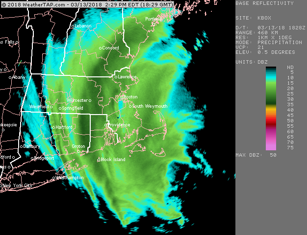
-
March 12/13/14 Blizzard/Winter Storm/WWA etc
ORH_wxman replied to Bostonseminole's topic in New England
Band congealing near and just E of ORH....that is impressive looking....BOS finally getting out of the exhaust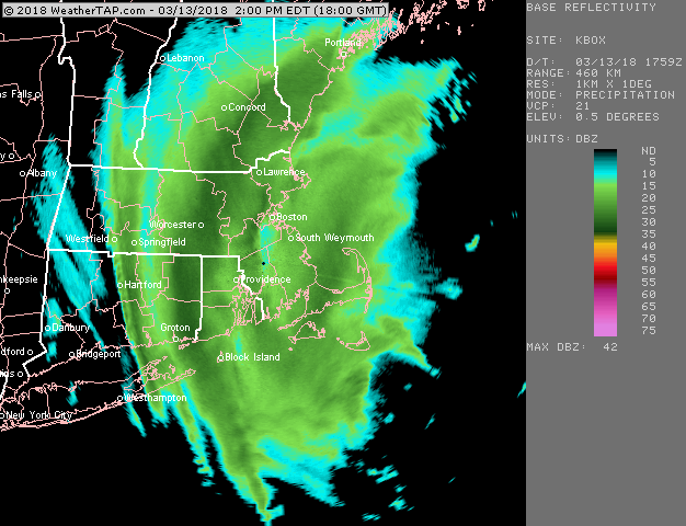
-
March 12/13/14 Blizzard/Winter Storm/WWA etc
ORH_wxman replied to Bostonseminole's topic in New England
ORH band starting to reform a bit eastward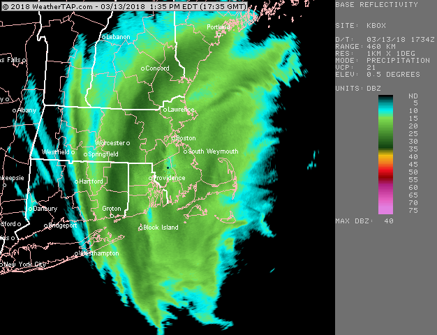
-
March 12/13/14 Blizzard/Winter Storm/WWA etc
ORH_wxman replied to Bostonseminole's topic in New England
Your area is def looking good for the next several hours. The new band forming in metrowest and the ORH/ASH bands slowly starting to move E after the pivot could congeal near you over to Essex county and down toward BOS eventually if things work out right for a good finale.

