

ORH_wxman
-
Posts
90,902 -
Joined
-
Last visited
Content Type
Profiles
Blogs
Forums
American Weather
Media Demo
Store
Gallery
Everything posted by ORH_wxman
-
Perhaps a Coastal Storm on March 2nd for SNE????
ORH_wxman replied to USCAPEWEATHERAF's topic in New England
Still quite solid in your 'hood....most of the 12z site is still a warning event in SE MA.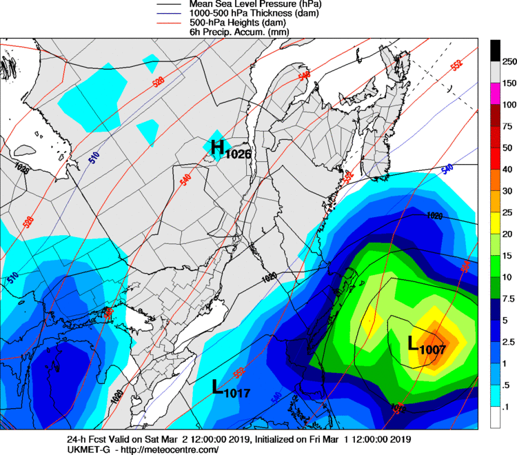
-
Perhaps a Coastal Storm on March 2nd for SNE????
ORH_wxman replied to USCAPEWEATHERAF's topic in New England
I'm not sure there's ever been a phase in this storm...it's really just a single shortwave...most of the question has been whats going on with the vort energy in this. It's weak and kind of diffuse. -
Perhaps a Coastal Storm on March 2nd for SNE????
ORH_wxman replied to USCAPEWEATHERAF's topic in New England
Ukie is solidly east from last night as well...can't see the queen maps, but we don't need to...it will likely look like a lot of the ones weve seen already based on the sfc/500 charts. -
Perhaps a Coastal Storm on March 2nd for SNE????
ORH_wxman replied to USCAPEWEATHERAF's topic in New England
That will depend on how much the midlevels close off...if you close them off, they will typically shove the fronto pretty far NW....but if they remain more open, then it kind of lingers barely north of the center. This isa hard storm to forecast...pretty big bust potential in all directions. -
Perhaps a Coastal Storm on March 2nd for SNE????
ORH_wxman replied to USCAPEWEATHERAF's topic in New England
Probably time to retire for good on weather model watching if that's the case.... -
Perhaps a Coastal Storm on March 2nd for SNE????
ORH_wxman replied to USCAPEWEATHERAF's topic in New England
Midlevels are definitely still nice for SE MA on most of these solutions...prob inlcuding much of BOS area and RI. -
Perhaps a Coastal Storm on March 2nd for SNE????
ORH_wxman replied to USCAPEWEATHERAF's topic in New England
Still a bigger hit than the mesos, but definitely E of 06z. -
Perhaps a Coastal Storm on March 2nd for SNE????
ORH_wxman replied to USCAPEWEATHERAF's topic in New England
GFS def looks SE of 06z through 18 hours...seems like 12z is all headed the same direction. -
Perhaps a Coastal Storm on March 2nd for SNE????
ORH_wxman replied to USCAPEWEATHERAF's topic in New England
The mesos are 12z are all in pretty decent agreement....advisory snow for interior SNE (less way out into NW MA) and maybe low end warning for SE MA/RI and perhaps parts of S CT. We saw this at 00z last night and then the globals went more robust (sans Euro)....then mesos came back at 06z only to go weaker at 12z again. We'll see what the globals do. The shunt east after it reaches the delmarva is still bothering me some though....not totally buying it. -
Perhaps a Coastal Storm on March 2nd for SNE????
ORH_wxman replied to USCAPEWEATHERAF's topic in New England
Looks late again.... -
Perhaps a Coastal Storm on March 2nd for SNE????
ORH_wxman replied to USCAPEWEATHERAF's topic in New England
RPM is in the meso camp...no surprise since its a meso model....has a low end warning event for most of SE MA, RI, and S CT.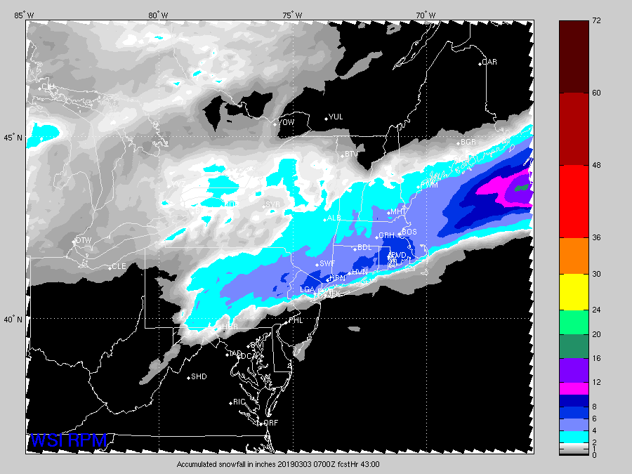
-
Perhaps a Coastal Storm on March 2nd for SNE????
ORH_wxman replied to USCAPEWEATHERAF's topic in New England
I'm not that concerned with the lakes shortwave....it's really how tucked in the system is against our main shortwave riding up through the TN valley and into the mid-atlantic. The lakes shortwave does interact with it some, and it will affect this system, but much more of the variance is due to how the vorticity is being handled....it's not strong which is giving the models fits on where to focus the conveyors. -
Perhaps a Coastal Storm on March 2nd for SNE????
ORH_wxman replied to USCAPEWEATHERAF's topic in New England
The water vapor shot that jimmy posted is actually pretty impressive. Makes it hard to envision a mere scrape. -
Perhaps a Coastal Storm on March 2nd for SNE????
ORH_wxman replied to USCAPEWEATHERAF's topic in New England
It definitely chases the convection once it gets going...it may have started off a tick east, but it gets exacerbated as we go into the run. You can actually see a couple little bullseye of vorticity south of the benchmark by 18 hours. Regardless, the lack of a compact vortmax is definitely an issue for a really wrapped up solution. -
Perhaps a Coastal Storm on March 2nd for SNE????
ORH_wxman replied to USCAPEWEATHERAF's topic in New England
This is sort of a chicken/egg argument and both can feed on eachother...if the vortmax is stronger, it will help force the flow to buckle and you'll see this tugged back west...on the flip side, if the flow was already a bit more buckled, you'll see the vortmax curl up to the north easier....even if it's weaker. The problem is we are dealing with a relatively weak vortmax right now...it's not this intense ball of vorticity which would make this a really big storm. So smallish features like convection can wreak havoc on the eventual progression of the whole thing. The pros: The shortwave is already negatively tilted pretty good...so that is going to help a lot. It's why even on these really ugly strung out solutions, we're still somehow getting advisory snow from ASH to ORH and SE and warning snows over SE MA. Cons: Vortmax is weak and the shortwave is relatively "shallow"....meaning it is somewhat disconnected from the main shortwave over the western lakes. This will give a bit of tendency to try and slide the low east....but it can also work in our favor if we deform where that happens. -
Perhaps a Coastal Storm on March 2nd for SNE????
ORH_wxman replied to USCAPEWEATHERAF's topic in New England
Yeah I think it's going to be almost impossible for this storm to be a total disaster (as in sub-advisory at this point) for at least the southeast half of SNE....but obviously the question is do we go more the 4-8" route or are we discussing 10-15"+? -
Perhaps a Coastal Storm on March 2nd for SNE????
ORH_wxman replied to USCAPEWEATHERAF's topic in New England
Yeah it's running northeast with the convective blob....suspicious, but it doesn't mean its wrong. Convective interference can be real...it's just that often it's an illusion on model guidance. -
Perhaps a Coastal Storm on March 2nd for SNE????
ORH_wxman replied to USCAPEWEATHERAF's topic in New England
Yeah looks worse than 06z...sliding further east. -
Perhaps a Coastal Storm on March 2nd for SNE????
ORH_wxman replied to USCAPEWEATHERAF's topic in New England
I can't see QPF, but the 06z EPS actually looks better than the OP run. Low looks a little healthier and isobars bulging more west. -
Perhaps a Coastal Storm on March 2nd for SNE????
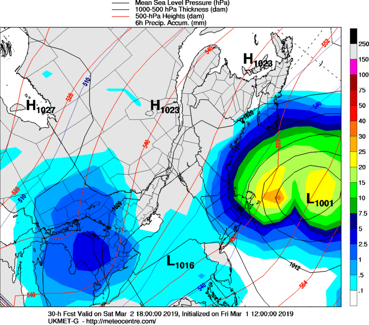
ORH_wxman replied to USCAPEWEATHERAF's topic in New England
WSI. This is 30 hours...you can see how it's kind of sliding southeast a bit and not curling up into the shortwave very well. This prevents a huge solution.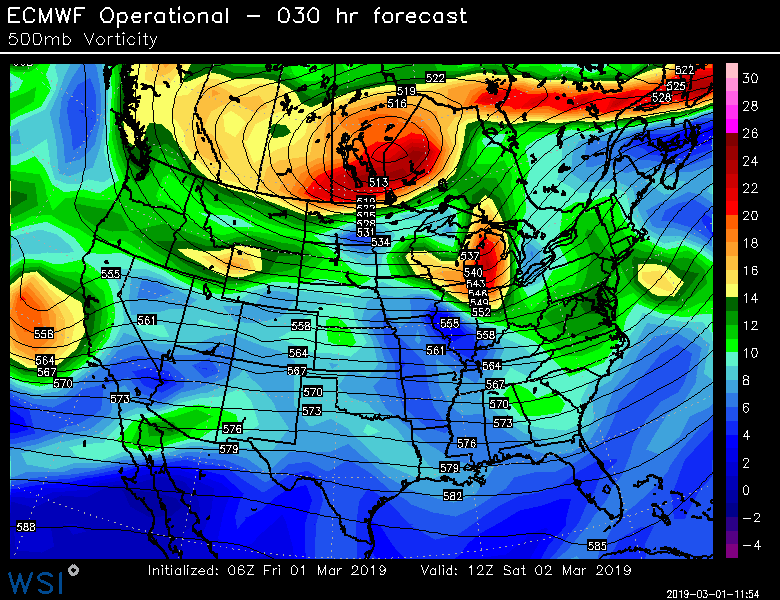
-
Perhaps a Coastal Storm on March 2nd for SNE????
ORH_wxman replied to USCAPEWEATHERAF's topic in New England
It is still shooting that southeast vortmax ENE as this gains latitude...this run was once again better with downstream ridging but it's having trouble really wrapping/curling that vortmax in toward the shortwave. But if we get another 2 or 3 incremental shifts like that we'll be in business for a big event closer to some of the other guidance. I'm not expecting something like RGEM/hi res RGEM lol. -
Perhaps a Coastal Storm on March 2nd for SNE????
ORH_wxman replied to USCAPEWEATHERAF's topic in New England
Definitely a little better than 00z but not by a lot. Small shift...nothing like that crazy 18z solution. -
Perhaps a Coastal Storm on March 2nd for SNE????
ORH_wxman replied to USCAPEWEATHERAF's topic in New England
06z euro is coming back some through 24h. Should be better than 00z. -
Perhaps a Coastal Storm on March 2nd for SNE????
ORH_wxman replied to USCAPEWEATHERAF's topic in New England
I mean, I don't know if that's the reason. I'm just speculating so keep that in mind...I'm just not sure how there's not at least a 50% chance of 6+ in SE MA/RI at this point. I get that they didn't see the 06z suite yet which came in pretty robust (pending euro in a few minutes). But even most of the cruddy solutions were still decent in SE MA at 00z. Anyway, doesn't really change anything in terms of what the storm actually does...hopefully Euro comes back a little in a few min. -
Perhaps a Coastal Storm on March 2nd for SNE????
ORH_wxman replied to USCAPEWEATHERAF's topic in New England
I'm really surprised there is no watch in SE MA and RI. I would think 50% confidence in 6+ there is warranted. But I guess this came on so fast that it's leaving everyone a little snakebit and that's been the background tenor of the winter.


