ORH_wxman
-
Posts
90,902 -
Joined
-
Last visited
Content Type
Profiles
Blogs
Forums
American Weather
Media Demo
Store
Gallery
Everything posted by ORH_wxman
-
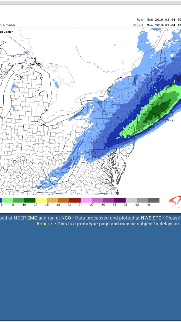
Really healthy mean:

-
Steady stuff into SNE, but you can see we have a ways to go before the real goods get here in S NJ and Delmarva area.
-
That's gonna be pretty heavy by 2am though the worst there might be a little after that.
-
Perhaps a Coastal Storm on March 2nd for SNE????
ORH_wxman replied to USCAPEWEATHERAF's topic in New England
It was not an easy forecast at all. We can often talk about some of the flags in hindsight but there were plenty of reasons it could have gone bigger too. We've seen systems where mesos struggle and the globals are able to better handle the system without getting confused by smaller vort maxes. Heck, even the euro had a very strong sig over E MA as late as 18z on Friday...not even 12 hours before the storm started. Its not easy to ignore that type of guidance. It's a lot easier to toss guidance when we're dealing with stuff like CAD, but when the Euro says we have to go decently big 12 hours before the storm, it's not easy when the mesos are skeptical. -
Perhaps a Coastal Storm on March 2nd for SNE????
ORH_wxman replied to USCAPEWEATHERAF's topic in New England
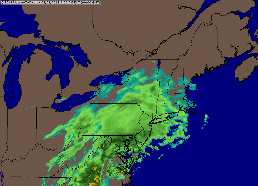
Some nice OES streamers in SE MA right now. -
Perhaps a Coastal Storm on March 2nd for SNE????
ORH_wxman replied to USCAPEWEATHERAF's topic in New England
Eyeballing between 2 and 3 inches. -
Perhaps a Coastal Storm on March 2nd for SNE????
ORH_wxman replied to USCAPEWEATHERAF's topic in New England
There's actually pretty good lower level inflow right now. 900-925 out of the east at like 30 knots. It's only like 10 knots at 850 so that will prevent much more intense banding but the lower level inflow should keep some pretty nice moderate snows for several hours. -
Perhaps a Coastal Storm on March 2nd for SNE????
ORH_wxman replied to USCAPEWEATHERAF's topic in New England
Pretty good band rotating up to N shore now....its back through here as well in Holliston and flakes are really good now. Coming down nicely....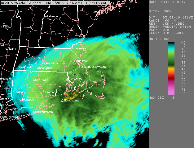
-
Perhaps a Coastal Storm on March 2nd for SNE????
ORH_wxman replied to USCAPEWEATHERAF's topic in New England
Flakes just dramatically improved. Eyeballing close to an inch so far. -
Perhaps a Coastal Storm on March 2nd for SNE????
ORH_wxman replied to USCAPEWEATHERAF's topic in New England
Coming down pretty hard now. Snowgrowth isn't great but it's reduced vis to like half mile. -
Perhaps a Coastal Storm on March 2nd for SNE????
ORH_wxman replied to USCAPEWEATHERAF's topic in New England
Snowing steadily with pretty decent band overhead. Hopefully we can pick up 2-3 inches before this is done by noontime. -
Perhaps a Coastal Storm on March 2nd for SNE????
ORH_wxman replied to USCAPEWEATHERAF's topic in New England
Bright banding is sleet. -
Perhaps a Coastal Storm on March 2nd for SNE????
ORH_wxman replied to USCAPEWEATHERAF's topic in New England
Just got back in from being out and what an ugly set of runs.....buuuut, still gotta watch that area moving into NYC. Guidance has been fizzling that too quickly all night...it actually may end up benefitting CT more than anywhere. -
Perhaps a Coastal Storm on March 2nd for SNE????
ORH_wxman replied to USCAPEWEATHERAF's topic in New England
18z GFS tickled east of 12z...though the low is actually better organized so it might actually prodce better bading in SE MA than a 12z solution would. Kind of looks like the 12z Euro now. -
Perhaps a Coastal Storm on March 2nd for SNE????
ORH_wxman replied to USCAPEWEATHERAF's topic in New England
RGEM looked better in a similar manner that the 18z NAM did...a little more consolidated. QPF wasn't much change except, again like the 18z NAM, it increased noticeably in SE MA in that PYM to EWB corridor and the Cape. -
Perhaps a Coastal Storm on March 2nd for SNE????
ORH_wxman replied to USCAPEWEATHERAF's topic in New England
Yes...it wasn't as strong on the euro but it had it. -
Perhaps a Coastal Storm on March 2nd for SNE????
ORH_wxman replied to USCAPEWEATHERAF's topic in New England
Yeah I was talking about it a few posts above...how it looks really good, but it doesn't necessarily mean anything yet. Though I find it interesting the lack of convection to the east of the Delmarva/VA which is where I'll keep looking. -
Perhaps a Coastal Storm on March 2nd for SNE????
ORH_wxman replied to USCAPEWEATHERAF's topic in New England
FWIW, here's the WV loop.....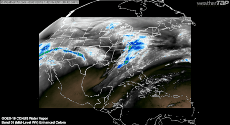
-
Perhaps a Coastal Storm on March 2nd for SNE????
ORH_wxman replied to USCAPEWEATHERAF's topic in New England
In the end, the 18z NAM did increase QPF for most of SE MA/S RI...esp PYM/Canal area and maybe back to EWB/UUU...prob owing to the better midlevels. It didn't change much over the interior. -
Perhaps a Coastal Storm on March 2nd for SNE????
ORH_wxman replied to USCAPEWEATHERAF's topic in New England
I've had the water vapor loop up in the backround the entire day....I keep waiting for something to show a more obvious turn east and I can't find it. I've been keeping an eye to the east for convection....so far IMHO, the mesos have overdone convection east of NC but underdone it back inland. It's a good sign but doesn't mean much yet...the key will be like 6-8 hours from now. That's when I feel like the skill of water vapor loop v guidance is easier to parse. You need like under 10 hour lead time.....the whole thing reminds me of when we sniffed out the model failure of 1/27/11....the models were trying to shove it east too quickly and it rode up the coast and smoked us. Of course, 6-8 hours form now, we'll have a bunch more short term model guidance and actual OP model runs too....so the whole exercise is probably pointless. But it's still interesting to me personally. If I looked at that loop without looking at any model data, I'd be thinking how on earth that could miss or only scrape us. -
Perhaps a Coastal Storm on March 2nd for SNE????
ORH_wxman replied to USCAPEWEATHERAF's topic in New England
Vorticity is more consolidated on the NAM thus far....that's a good thing. But so far, it's not quite enough to really consolidate the midlevels so this solution may still be dogshit. -
Perhaps a Coastal Storm on March 2nd for SNE????
ORH_wxman replied to USCAPEWEATHERAF's topic in New England
Nah...take 'em up in BOS. -
Perhaps a Coastal Storm on March 2nd for SNE????
ORH_wxman replied to USCAPEWEATHERAF's topic in New England
Sun angle is tossed during any meaningful snow. Might make the afternoon lighter stuff less impactful...esp on the roads and any blacktop/driveways/etc....but during anything resembling moderate to heavy snow, sun angle is tossed. -
Perhaps a Coastal Storm on March 2nd for SNE????
ORH_wxman replied to USCAPEWEATHERAF's topic in New England
It's better for most of SNE...the best bandng is east of you, but you still want the more tucked look on the vort energy...that will give the best chance for good snow there too. -
Perhaps a Coastal Storm on March 2nd for SNE????
ORH_wxman replied to USCAPEWEATHERAF's topic in New England
Def an improvement aloft on the 12z Euro....bucks the trend of the rest of the 12z suite. That is a good banding look.