ORH_wxman
-
Posts
90,902 -
Joined
-
Last visited
Content Type
Profiles
Blogs
Forums
American Weather
Media Demo
Store
Gallery
Everything posted by ORH_wxman
-
Damn Alex, nice pad. Love the porch on that thing. I'd spend all day out there. Well done.
-
Yeah that area is very good but it's pretty far west. I was mostly talking areas within a stones throw of ALB like Duanesburg. But once you get up onto that big helderberg plateau area it's all pretty good. Some of those exposed areas have crap retention though. It was always weird driving through there in winter....you'd be in a good spot and see big snow pack and then an exposed area even if it's high elevation may have bare ground everywhere. The CAD gets much stronger to the north like off to the west and northwest of Saratoga.
-
I'd say the best spots are if you can get into the Helderbergs NW of ALB...like those spots up over 700 or 800 feet it seems to make a big difference. Like west side of Duanesburg and such. I always remember snow pack increasing quickly that way heading west. If you don't mind being a bit further out to the NW then start going out west of Saratoga and towards Gloversville...that's starting to get like 45+ min outside the city though.
-
CT had a ton of dryslots in some of those early 2000s storms that destroyed ORH and obviously back to western MA on some of them. Storms like Xmas 2002, Jan 2003, feb 2001, and really sore spot was January 2005...dryslot raced through CT and then hit a brick wall about 15-20 miles south of ORH near the border. I was watching and never thinking it would initially reach us but then started sweating it out a bit before everything started collapsing back SE....dryslot never even really got too much of RI either as it filled in. But for CT the damage was done. Some spots only got like 8-12" when like 18-24 was forecast.
-
Yeah and most of those lines were from the late 1990s...wasn't exactly deformation band central for eastern SNE those years. I think they studied April 1996 through spring 2001. They didn't just do snowstorms either. All cold season events.
-
Pretty easy to see the Feb '01 band on that map.
-
Yeah I always recall GFL still being like 24F in CAD events when ALB has already gone to like 33F and rain. That valley narrowing and then turning to the west is def a huge part of it....once you turn that valley to the west, it's like a wall in front of them. Also being narrower too up there helps even if it didn't turn to west....we see the same phenomenon in N MA in the CT river valley. The 65" does sound a bit low to me too...but that's from the airport through 2001....so the obs are pretty pristine. There's basically no missing data until 2001 looking at the daily data when they stopped the snowfall obs. So it might be accurate....but maybe it "seems" they have more due to their elite snow retention. Also the airport is at 300 feet....spots to the northwest in Queensbury around 600-700 feet probably do get several inches more.
-
Glens Falls is about 65" for mean snowfall but the airport hasn't reported snowfall since 2001...so that number may or may not be higher now if we had theoretical values since 2002. If 65" is accurate, then it's just a smidge less than ORH for annual snowfall. However, they average more days with 1" of snow on the ground with about 86 days (again, this is 2001 and prior years) vs around 75 for ORH...they are far better than ALB and the lower Hudson Valley at CAD given the Hudson turns to the west where they are...so their valley runs more E-W than N-S like down by ALB. Their latitude is also helping out here. Their latitude is a bit north of CON's latitude. They also average more number of days with 6"+ snow cover than ORH but are about the same number of days as 12"+. Basically, they have a very good location for retention. Out of curiosity, I checked BTV...and BTV does worse than GFL for days with 6"+ of snow cover but better for 1" of cover. BTV does significantly worse than both ORH and GFL for days with 12"+ of snow cover.
-
I'll have to double check the numbers but glens falls will def be higher than Troy/ALB
-
Yeah it's ok...I wasn't saying it isn't, but I'm just giving the empirical numbers vs the areas being discussed....I always drove through there back and forth to Cornell, and the hills (Helderbergs) to the west are actually pretty good. But it's worse than probably anyone in interior SNE that is outside of 128 in MA and probably near Ginxy or northward in E CT and W RI....it's better than the CT Valley though from like Springfield to HFD for sure, but probably not once you reach Hippy's area in Greenfield....they get similar snow but the retention is superior up there vs HV.
-
Yeah, N Foster coop averages 65 days with >= 1 inch of snow cover since 2000 whole ALB is 59 days. The gap widens for 6" depth....32 days to 22 days in favor of N Foster.
-
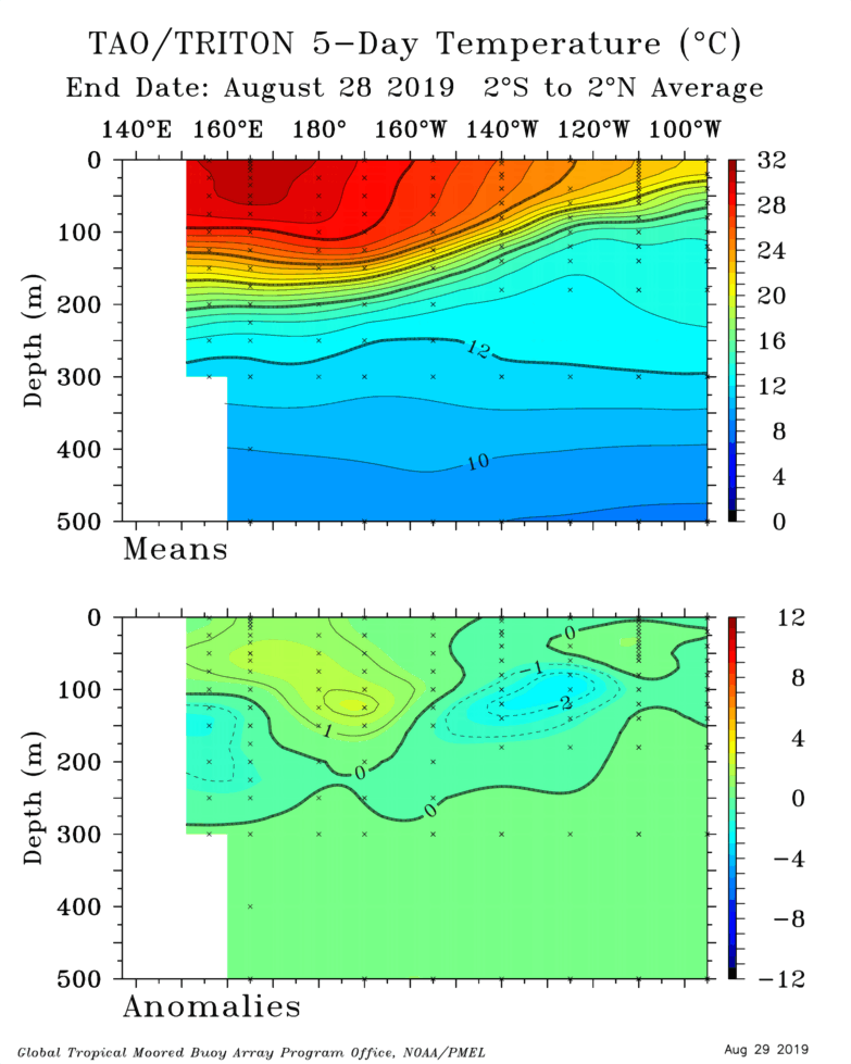
The daily area did start falling again....but it was only 18k. Down to 2.981 million sq km....the min so far was 2.877 on August 24th.
-
That was their snowiest winter on record just looking at the numbers now. Also blew other years out of the water for most days with greater than 6" of depth....and only trailed 1947-1948 and 1970-1971 for most 12"+ depth days. So yeah, if that is the most influential impression of winters in Albany for you, then you definitely would have an inflated view of their snowfall climo.
-
BGR is snowier than both ORH and Troy. ORH is probably slightly snowier than Troy on average, but maybe something like 68-70" versus 62-64"....BGR is probably more like 77-78" avg so once you are comparing it to Troy, it's prob a good 20-25% more snow on average. It also depends where you are talking about too....BGR airport are my numbers, but if you are talking a town or two southeast of BGR like right on the water, the numbers are definitely going to be lower. BGR is going to have the superior snow depth a lot of the time on both stations simply because they are colder and average more snow....though with ORH it is closer than with Troy. BGR will average around 95 days per years with snow depth >= 1"....ORH is closer to 75ish. Troy is more like 60. So if you hate bare ground, you definitely want to eliminate Troy out of the 3. The numbers don't change for large snow pack...for days exceeding 12" of snow pack, ORH averages around 18 per winter....while Troy/ALB average around 6. BGR averages around 25.
-
Biggest difference betwen Troy NY and ORH is going to be snow retention. It's a lot worse in the Hudson valley. Theyll get more smaller snowfalls too like 1-2" from some squalls and windex stuff than you see in ORH.
-
That's the 5-day mean, the daily area actually increased 20k to 2.999 million sq km. Not that the area matters much anymore for ranking purposes...this season will rank 3rd lowest for area behind 2012 and 2016.
-
He'll be back soon...usually his tantrums don't last more than a few days.
-
There's some weak support for it...obviously we know how early it is and how quickly things can change.....but we've got a big warm anomaly in the GOA (positive PDO) and extending down into the adjacent north pacific. That's going to at least feed back on any ridging that tries to develop there (I won't claim it is the cause of such ridging). We've also got the best chances for warm SST anomalies in the ENSO regions out near the dateline. ENSO is weak and likely neutral, but it still probably helps on average to have that "west based" Nino look...heck, it might even be better this way than an actual El Nino because, like you said, maybe less chance for other ENSO-related factors to muck it up. We just get this weaker low-frequency backround humming that tries to force the tropical convection near the dateline....that then promotes ridging in our EPO region...which then feeds back on the big warm SST anomalies sitting there, and boom....you have that mass Siberian express pattern that gets stuck for weeks at a time. Who knows what the Atlantic will do...and obviously all those shorter-period oscillations will have a large say in our snowfall prospects, but the larger scale definitely has some weak support for cold idea.
-
Models continue to go more neutral on ENSO as we get closer. EuroSIPs and seasonal did too...so I'm getting increasingly more confident that we will be La Nada (neutral) this winter. Still a small chance we go weak Nino, but it's becoming more of a long shot. Subsurface looks weak...still some warmth to the west but the central and eastern areas are getting cooler in the subsurface. That's probably good though...even if we're neutral, we'd want the higher anomalies out west...maybe encourage dateline convection.
-
Nah, no heavy rains for CT.
-
Best precip for SE MA looks like late evening and overnight.
-
Different mechanics usually. The snows from NW bands are typically from ML fronto and upper level deformation which is often northwest of the best low level forcing and that's why models often struggle with it...with warm season rains there's a lot of convective processes. Usually the low levels will matter more on that.
-
Man, after he called for no rains in CT. After a blistering start in late June and July, the KFS is having a 2004-Yankees-esque meltdown.
-
Between 1955-56 and 1971-72, ORH basically had zero years below average snowfall...they had one year (I think 64-65) where they had 62.8", so slightly below normal but I consider that normal when it's only like 10% below average. That period was amazing for its consistency. There were only maybe 3 or 4 winters out of that 17 that I would classify as "blockbuster"...it was just consistently solid. Normal or above normal with a lot of cold. Very cold those years. Then the early to mid 1970s flipped the script until we returned to epic cold and snow for a couple winters in '76-'77.
-
Yes they are. It's why I think people who haven't actually experienced a stretch like that won't truly understand what we're talking about until they do. Pretty much anyone born after 1985 or 1986 probably wouldn't remember...maybe a young weenie born around then would remember the early 1990s before the tide turned...but otherwise, they are used to never going too long without a huge event or blockbuster winter. Its even more spoiled for anyone born post-1994 or so...they wouldn't even remember the relatively dud winters of the late 1990s.