

ORH_wxman
-
Posts
90,902 -
Joined
-
Last visited
Content Type
Profiles
Blogs
Forums
American Weather
Media Demo
Store
Gallery
Everything posted by ORH_wxman
-
Yep....you can't talk about temps well intot he 80s for highs and then also talk about "normals in the 60s"...it's like he wants to use the BDL high against ORH's climo....yeah, of course you'll get some big + departures, lol. +20 for a high at ORH is gonna take upper 80s. That has happened like 4 times on record at ORH after 9/20....twice in 1970, once in 2007 and once in 2017
-
ORH falls to an average high of 69F today. BDL doesn't fall to 69F until September 30th,....BOS falls to 69F climo high on September 25th.
-
We've said it on here before...but worth repeating: Wait until we get another 1979-1992 stretch. Then the real whining will begin. For the entire existence of these forums in one form or another, we've been in a prolific time for snowfall. Yeah we get the occasional ratter, but it is quickly "rewarded" with a juggernaut within a year or two. The real fun for the masochists will begin when the ratters are followed up by 2 or 3 more....ha.
-
It definitely is still about expectations though. Someone in NNE who averages 100" of snow per year would be pissed off if they got 75" and had to watch Boston get 70". They would have gotten more snow than Boston but that would still be annoying because they probably are missing some pretty sizeable systems if Boston is getting 70" while they are well below average. Same deal down here vs lesser snowfall areas. I'd be annoyed if I got 55-60" and watched Bridgeport CT get 50". I would feel that we were missing the brunt of the good action....it would probably mean some pretty big storms were hitting to the south of us.
-
Once the north trend has a couple months to work, it will be a pike-north winter.
-
N LI has been doing it for decades. Not just recently. They got great deformation bands in the March 2001 storm (which salvaged it there to some extent vs NYC) and April 1996...blizzard of '78 too going further back.
-
I like the distribution in the ENSO belt. Cold in the east and central...warmth near and just west of the dateline and then cold again once near New Guinea and westward. Could help focus convection in the right spots. Hopefully that spacial distribution holds fairly steady.
-
45F last night here. House was noticeably chilly this morning but didn't quite succumb to turning on the heat. Decent WAA today so we will let it do its job.
-
Next week looks pretty amazing though....we get stuck under that Quebec high that slowly drifts SE. Starts off probably a bit BN next week and transitions to a bit AN as the thicknesses fill in over the high.
-
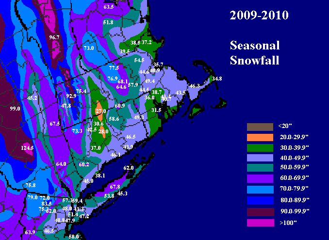
Nobody on the CP had that much, but into the interior PA and MD hills they got close to that (not counting actual mountains here). My map doesn't get all the way down into MD...but you can see even interior hills of NJ had over 80 inches. But that actually isn't unprecedented for there...they have had seasons over 100" in the interior hills of NNJ....1960-1961 and 1995-1996 come to mind. Maybe 1957-1958 too....'66-'67 was about on par with '09-'10 with some 80-90" totals there. NW NJ kind of whiffed on the December 2009 storm and the Feb 5-6, 2010 storm which surely cost them a run at the record books if they had gotten both. If you include actual high point in the NW corner, you could include a lot more years too than the ones I listed above.
-
If that same longwave pattern happened again....it would be almost certainly be more prolific for NE.
-
Yeah last year was your first here? Pretty much a dud...esp in HFD area. Good chance this year will be better.
-
I hate bare ground in winter. It's uglier than a glaciated pack imho.
-
Easily...at least '09-'10 had snow pack for most of the winter IMBY. It was frustrating, but we pretty much kept our pack from 12/5 onward that year until a bit before the disaster March rainstorm. '11-'12 had long stretches in every month with bare ground....including just about all of December.
-
Non-radiator ORH got their first 40s last night. They had hit 50F a few times but not below that.
-
Only if you disturb their nest, then they go insane. White faced hornets (same thing as bald-faced) are not nearly as bad as yellow jackets though once you get away from the very immediate area surrounding their nest. They will typically go about their business without bothering you whereas a yellow jacket will be much more likely to sting you away from the nest. Yellow jackets love to get up in your business and then if you try and swat it away, it has no problem stinging you. The white faced hornet stings are really painful though...worse than yellow jacket stings. They just don't happen as often.
-
Yeah 5 in and out every second is a massive nest....that rate of activity would scare the sh** out of me. The nest I killed on the eaves of our house back in July was probably 1-2 every couple seconds....I estimate it had to have 100 in there....it would have ballooned to like 500+ by now if I didn't get it. It was above our deck and with my 3 year old son liking to play out there, there was zero chance I was letting it go even if it was 15 feet up. It took me 3 cans of raid to kill it over the course of about 7-10 days. Your youtube video looks bad too...that's a big nest with that much activity.
-
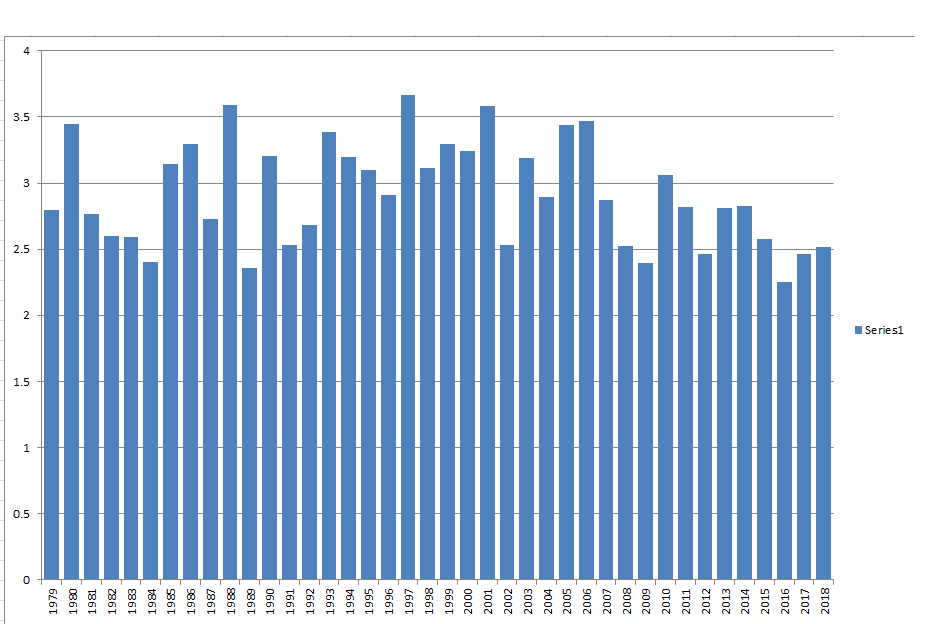
Time to verify this prediction based on the data at the end of June. Assuming we have reached the minimums for both area and extent on 9/4 (looking more and more likely), then both of these fell outside my range, albeit not by much. The final minimum area was 2.87 million sq km and the final minimum extent was 4.23 million sq km. These are both NSIDC numbers. The predictions were looking excellent through mid-August until we had an unprecedented slowdown in late August that has leaked into early September. So I ended up making predictions that were slightly too low compared to reality. I was correct in identifying the very strong chance of a top 3 finish (and also being skeptical of challenging the top spot), but I really needed to bump my middle numbers in the range up about 100-200k. Overall, I think this was a decent prediction compared to what we see on the Arctic Sea Ice outlook that gets published by NSIDC....but I am still disappointed I could not get it within my range. It might be that 200k error bars are just too small to consistently hit on predictions when it comes to sea ice. Using 400k error bars would have this method hit every year I've done it with the exception of 2016. But I will probably try to continue to use 200k error bars....and maybe see where the method can be improved.
-
A quick look at their top snowfalls says that she must definitely move away soon. Only 4 of them are double digits and two of those 4 were measured using oxen and knickers so they are probably fake.
-
I'll do it by type of event: Snowstorm: December 1992 with close to 3 feet of high water content snow....it would speak for itself back in the ORH hills regardless of when it occurred....but the fact it was the storm "that broke the snow drought" made it even more memorable. It was the first double digit snow event at ORH since January 1988. The longest stretch on record there. What a way to break the streak. Ice storm: December 2008. About an inch and a half of ice at 31F. Amazing event. Most people posting on here were on the forums for this one so they've seen all the pics and such even if they didn't directly experience it. Can't match January 1998 up in NNE but basically no ice storm can. Severe: The May 31, 1998 macroburst at ORH. Produced a 104mph wind gust at holy cross. Just shy of 100mph at ORH airport. I was legit scared it was a tornado when I heard the winds starting to whistle while under a tornado warning. Made it to basement as we heard a massive crack. 3 foot diameter tree broke next to us. Tropical: Chased Irene on the Cape with Phil and we got sustained around 60mph with gusts near hurricane force. Pretty good all things considered. Slim pickens in New England the past 2-3 decades. Bob in '91 had some pretty good flooding but not great winds back inland. Heat: Probably July 1995 only because of the dewpoints with it. It wasn't as intense as 2011 but it was more uncomfortable. Cold: January 2004 if we're going on combo of longevity and pure misery. Thin snow pack and brutal winds. If we're going on just shear peak magnitude it's Valentines Day 2016....absolutely brutal. Only lasted about 36 hours but it was epically intense. Froze our shower drain for over a day. January 1994 gets a mention of throw some wintry appeal deep snowpack into the equation....and the lowest daytime max of 1F. Recently tied this past January.
-
CAR going from +1C to -8C in one hour I impressive on the '76 cold front.
-
The euro seasonal has a warm bias at the surface. So you really want to see H5...i haven't seen the September run but the August run looked pretty good aloft.
-
When making a post you can go to the "insert other media" option below the typing box and select "insert image from URL" and that should post an image from a link. But like dendrite said, make sure the link has an image file name at the end like ".jpg", ".gif", ".png", etc. Your link didn't have that at the end so you need to hold down directly on the image and copy it and it should copy the location of it.
-
Yeah the summer has some convection too that starts to dissipate in august and september. Not that convection is a huge deal in New England, but we do get occasional severe. September only very rarely has good severe. So it's basically like summer except eliminate the severe threats and eliminate big dewpoints and eliminate potential for high end heat (like upper 90s)....it's really just kind of boring unless you get the rogue TC or a rare late season severe threat. Agreed...August this year was amazing. There were very few days that felt uncomfortable outside. Had the windows open most of the month.
-
September is probably our best weather month of the year. Lots of lower dews and comfortable highs and it tend to be one of the drier warm season months. It makes for awesome outdoor activities, but it's also really boring from a meteorological standpoint unless we get threatened by the rogue TC. I've always found it to be one of yhe quieter months on the forum locally...obviously for the tropical crowd, they have that to track.


