

ORH_wxman
-
Posts
90,902 -
Joined
-
Last visited
Content Type
Profiles
Blogs
Forums
American Weather
Media Demo
Store
Gallery
Everything posted by ORH_wxman
-
Almost the same date as 2011 too.
-
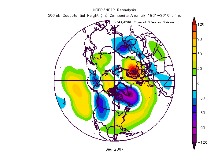
Yep, that's really a similar look to Dec 2007....the +NAO vortex was so big it encroached into New Foundland and Quebec so we got these stout highs there that caused all the would-be lakes cutters to run into a brick wall.
-
Def a bit of a Nina look....Tip is going to be singing the geopotential gradient blues if that verifies. Look at that meat grinder east of Maine.
-
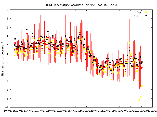
I dunno....I'm not sure how this would pass any QC into NCDC for climate data....but then again, they used to take goose eggs for ORH snow data, lol. Maybe 2-3F isn't enough for them to care that much....priorities and all. But I suspect if they start doing 5F consistently, then it will be attended to.
-
It depends on what the problem is to begin with....if it's a siting problem like rocks or dark ground recently put in near the ASOS, then yeah, you'd expect to see the effect decrease a bit in winter. But if it's a problem with the actual ASOS temp sensor, then it won't go away. There doesn't seem to be a big change last winter when the problem started....we see a little fluctuation but generally staying consistently terrible compared to mid-2018 and prior. BTW, look at how much of a joke those high temps hae been recently....over 5F too warm now.
-
EPS hinting at cold to end October....out at end of run, so we'll see if it gets closer with time....but chilly Halloween week?
-
This is good advice for pretty much everything...not just weather. Lol.
-
I think you mean March 2018....but yeah....it's been pretty rare recently. These things tend to swing back though....we couldn't buy a -NAO for a few years in the late 1990s as well. We don't really need it super negative...even neutral is pretty decent.
-
We did well in 2010-2011 because had an obscene -NAO....and a -PNA is not some sort of death knell for New England. So many people get wrapped up in that. I feel like I say until I'm blue in the face, but a -PNA/-NAO combo is probably our best snow pattern. We literally went almost the entire 1960s with that setup. 2010-2011 was also that setup with the NAO on 'roids a bit more than normal.
-
There's a reason I've been camping out in the winter thread. This has been a snoozer outside of far SE Areas. It's s nice storm for them but back our way it's run of the mill October wx.
-
Whether it registers as an official Niño or not, I made the comment a while back that i really like the western regions being a lot warmer than the east right now. The physics of that doesn't change whether it officially registers...it should still make convection more likely near the dateline versus further east and that is a good thing for winter enthusiasts. The tepid nature of the anomalies though understandably diminishes the overall impact. I know Tip hit on this point. But still, all else equal, we'd rather have the warmer anomalies west and not east.
-
2012 is a good match too...cold waters in the east can get drawn west pretty quickly if we have an easterly wind burst. So that's why I want to see some good WWBs. I'm not trying to totally discount a Nino, I just think it's still not a foregone conclusion. A lot of us we're getting convinced of a weak Nino in autumn of 2012 too before it crapped out pretty fast in November.
-
I'd bet dollars to donuts that none of them had Nino 3 as cold as it is this year.
-
Maybe...There's a lot of cold water in the east that could keep this neutral though. The subsurface has some good warmth out in the west parts so maybe that surfaces even more, but there's no way to know which will win out....or at least that is beyond my pay grade. Lets see some WWBs though if it's gonna happen....it's getting late. We're already in October. Something developing by December may not matter that much for winter.
-
I don't think that was the big issue in the way I'm talking about it. We weren't lacking in events or overall QPF. Now maybe it played a role in not having a coastal bomb? Sure I buy that. We didn't have a coastal bomb in '07-'08 either likely due to the fast gradient flow. But we still had plenty of snow events.
-
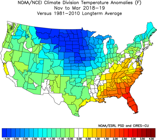
There was a lot of really cold air masses oozing over the top last winter. You can tell from the map where the upper plains were frigid. ORH actually had their coldest max temp since 1994 (1F for a high tying 1994) last winter. There were some impressive airmasses. We just couldn't quite get those good highs that give interior SNE big snows on the front end of a lot of those systems. Obviously the deeper cold in NNE was able to which is why there was a big snowfall gradient.
-
It's part of the reason I think I would definitely roll the dice again on last year's pattern in the pike region. I know others had disagreed, but I think we caught a lot of "unlucky" breaks (or rather, some undesirable small scale perturbations within the large scale pattern for those who are triggered by the work "luck")...it wasn't a great pattern, but we typically snow more in that type of setup than last year. We had an unusual lack of good front enders/triple pointers here considering the source region of the storms along with the mean temps.
-
MVL is prob a bit colder than others, but overall it was colder than average up north....even down into SNE too. November being included flips SNE negative. ORH was about dead nuts normal without November included (-0.3F without November vs -1.2F with):
-
PAC is starting to look a little more Nina-esque.....not just ENSO region either, but the waters in the eastern GOA have been cooling recently with the warmest anomalies south of the Aleutians...that's trending toward -PDO. It isn't actually there yet, but if that trend continued, that's what it would end up as. That, along with the cool-neutral look in the tropics gives it a hint of Nina. That might increase the odds of a more wintry December....but these things can still change of course. The waters in the N PAC can shuffle with a few big cyclones. The tropics are still the most influential...but this is something to watch.
-
Meh. Way up high in that tree means they are worth keeping around. They won't bother anyone being that high up unless you build a tree house. Theyll be useful in killing other insects and even killing yellow jackets.
-
In the 1990s, I very often had the "glad we don't live there" thought when I saw obs near PVD and southward during winter storms.
-
As epic as that year was, the 2nd half of December and a lot of January kind of sucked (though we did sneak in a solid warning event in January) ...obviously can't ignore the dec 11-12 storm but we stagnated for quite a while after that. Obviously things really picked up again in February and the epic March.
-
Feels like the talk of a torch October is in serious trouble looking at the extended.
-
We tried to tell you when you were swearing and throwing furniture in the basement when models showed 80F temps on September 30th....we knew you'd come around. 60/38 loses its novelty pretty fast. Give me 77/52 any day. Don't care if it's a +17 departure in October. Beats this garbage. Like I said, I'll tolerate a good hard frost or freeze to get rid of the remaining bugs but then I want Indian summer the rest of the month. We can go back to cold at Halloween and beyond.
-
Yeah I hate using percent of normal for snowfall...it's not apples to apples between sites. Need to use sigma (standard dev) instead to standardize it. But I think too many people's eyes gloss over when we start talking about a 1 sigma or a half sigma snowfall season.

