ORH_wxman
-
Posts
90,902 -
Joined
-
Last visited
Content Type
Profiles
Blogs
Forums
American Weather
Media Demo
Store
Gallery
Everything posted by ORH_wxman
-
12 out of the past 16 days have had highs in the 50s at ORH with the other 4 in the 60s. Slightly cooler than I prefer but it's been ok. Could be worse with highs in the 40s and rain.
-
Depends on which guidance is correct. Euro/EPS is trending toward dropping everything into the west and southwest while the GEFS and Canadians do not so they are frigid near Halloween. EPS have higher skill at this range so you'd hedge a bit there. But they've also been awful a couple times already this fall overplaying warmth up here.
-
They got around 2-3 inches in Foxoborough....they were in a perfect spot and also that couple hundred extra feet helped.
-
I don't know for sure on this so I don't state it as fact....but it seems the seasonal climate models have some sort of backround warming component mixed in because I almost never see cold anomalies forecasted by them over the CONUS. I usually just look at the H5 anomalies to decide whether it would be cold. It shows a monster -EPO ridge over AK and then somehow thinks Bismark ND is going to be +1.....uhhh, no. It's almost as if they don't have their weighting correct in the model....
-
As long as the Deer Island water treatment plant reports a trace, we're good.
-
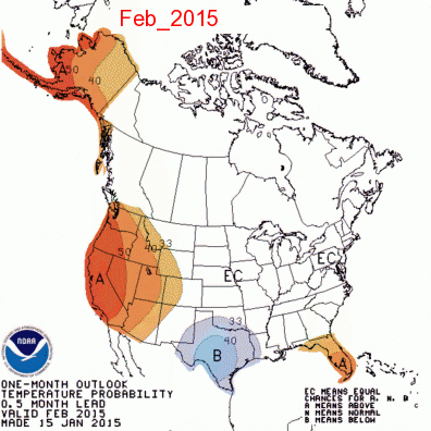
How about a 1 month lead time?
-
Yeah but you'd have to hope ORH doesn't get 6" if you get 5" or winter is ruined.
-
Apparently it's 6"+ at ORH and any measurable at BOS. Not sure if anyone has run the numbers for CON.
-
Ensembles have a -EPO, mildly +PNA and -NAO around Halloween and to start November....decent chance for first flakes for at least some in this forum....obviously NNE favored, but that could produce flakes in SNE too.
-
Yeah that's not a warm look here at all. Def not as cold on the anomalies as the N plains would be but we'd be under some confluence there most likely. Either way, who knows if that actually verifies. Fodder for the anxious souls though.
-
Looks pretty cold around Halloween on ensembles. The initial trough before that gets cut off so we don't get as cold in the Oct 25-28 range as it looked earlier, but then it looks like the real stuff comes down after with a pretty impressive PNA ridge. Still out in clown range though...so details can change. But the building western ridge has at least been pretty consistent.
-
This was kind of a weird event. It was really high end right on the coast...models actually showed this pretty well where inland even 10 miles was drastically less impact. Some events can rip well inland (ala October 2017) but this one was basically if you were on the coast, you got absolutely crushed but just inland it was a typical strong storm (windy but under HWW criteria)...might be able to mix down a few HWW gusts on the WSW CAA today...esp southern areas and if we get some extra sunshine to steepen the LL lapse rates.
-
I see 53 knots (61mph) for PYM. That's pretty solid for that sand pit. Bet there was easily hurricane force hitting the pine hills close to the water.
-
Prob some gusts around hurricane force right on the water in that area.
-
Was pretty meh once you got inland a bit. Impressive on the coast though. They got smoked.
-
2017 was solid. Started with that nice warning snowfall on 12/9 and then included the Christmas Day snow. Good wintry month
-
Yes. I posted how crappy really warm novembers were but the opposite tends to happen with cold novembers. There's exceptions of course (1997 and last year are two off the top of my head...1989 too I guess...kind of a meh winter). The correlation isn't monstrous. But all else equal, we want a colder November.
-
November temps correlate somewhat...we don't want a torch November....like +3 or more. That has a pretty bad track record. For ORH, here are the most recent Novembers that finished +3 or more 2015 2011 2009 2006 2003 2001 1999 1994 1982 1979 1975 Not a single blockbuster winter in those with plenty of full-on ratters.
-
So if we remove the 2 octobers that produced 6"+ snowstorms, we are left with a bunch of octobers that had measurable snow and produced an average winter of over 80". Therefore....we should root for October snow as long as it isn't a blockbuster over 6".
-
Lol
-
I've posted the stats for ORH before which has a much larger sample of measurable October snow than a place like BOS. ORH October snow has no correlation with total winter snowfall.
-
How many times are these overdone? Probably 99% of the time.
-
Yep, you want to be just east of the low track in this setup to get anything decent...and assuming it is a rapdily deepening 970s system...if this stays kind of meh on intensification then I don't expect that much anywhere.
-
Yes it is that one. It was a big ocean storm that sort of stalled and then backed up after cold air filtered in and gave eastern areas some snow. Kevin wouldn't have gotten any in that system. I remember Megan and I drove up to the summit of blue hill in that to check out the snow. They had a couple inches at the top.
-
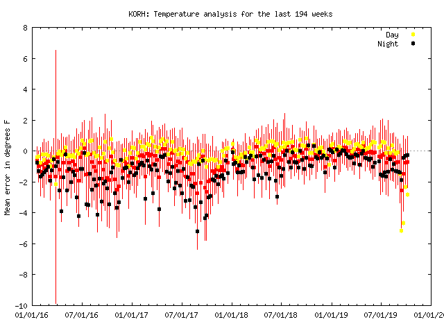
ORH looks totally fine on MADIS. It basically hasn't moved the past few years aside maybe a brief spell in 2017. Pretty consistent. Nothing like BOS. I'd also argue that BOS should be running departures way cooler than BDL and MHT right now given the pattern we've been in. They've had like 2 hours of sun in the past week.