

ORH_wxman
-
Posts
90,902 -
Joined
-
Last visited
Content Type
Profiles
Blogs
Forums
American Weather
Media Demo
Store
Gallery
Everything posted by ORH_wxman
-
I count you as mountains since you enjoy the advantage of the upslope components. I was more speaking for areas like central NH over to the lakes region in Maine eastward to midcoast. Those areas usually require something a bit more than moist CAA flow to generate measurable snow.
-
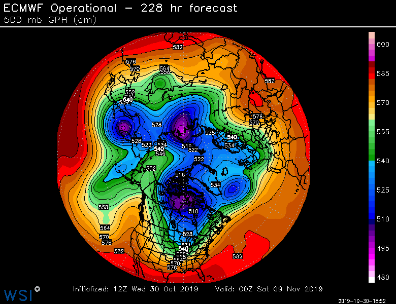
Euro goes cutter this run. Screaming south winds. Cold wont be denied though eventually even on this look...checkout that building over EPO block at d9...sending another brutal arctic shot south but it would end up a lot further east wth the block bullying its way into the central arctic. Either way, prob getting some real cold...exact evolution/dates TBD
-
Of course, the 12z run is now dropping the PV lobe way west compared to 00z and that changes the whole d8-10 look. But that's another Arctic blizzard for the front range.
-
Most of SNE looks dryslotted tomorrow evening.
-
Euro ensembles have the disturbance as well. It's 9-10 days out so it doesn't really matter at this point but there's going to be some legit cold around and if the embedded shortwaves cooperate then it's totally realistic to see a snow threat. Its not like 11/8-9 is the same as October....we're starting to get into more realistic time frames for first measurable...esp for interior zones and into NNE non-mountains.
-
Maybe we should just forward the 10 commandments of winter wx forecasting to Uccellini and tell him not to approve any GFS upgrades until the commandments have been answered?
-
Gonna be really hard for him to ignore the FV3 when it's showing a snow blitz and the euro says not a chance.
-
That makes sense. 22z would be 6pm and it was still light out so that matches my memory. Doesn't get dark until closer to 7 in late September. Looks like it started around 5:40pm.
-
I wanna say late afternoon?
-
I'm sure the Ecmwf.int crowd would be happy to help out...
-
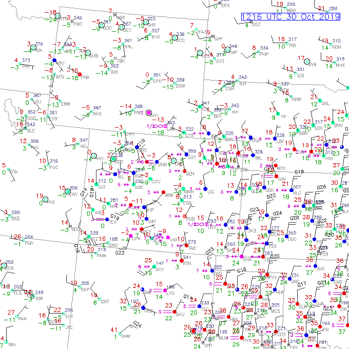
Btw, how's this for an October morning? 4F and snow in Denver. Currently tied for all time record low October temp. Dropped 2F this past hour so good chance they break it.
-
Def looks like the main vortex gets far enough south to put us on the north side of any disturbance that gets embedded in the flow.
-
There's plenty of peer review research to read that will argue humans aren't responsible for the increase in CO2, but in reading them, you'll note that they don't hold up under scrutiny as time passes and other papers rebut them and they aren't able to counter those rebuttals. So they are fewer and fewer these days. I would suggest reading literature across all spectrums and not try and muck up the thread by insisting you know more than these papers.
-
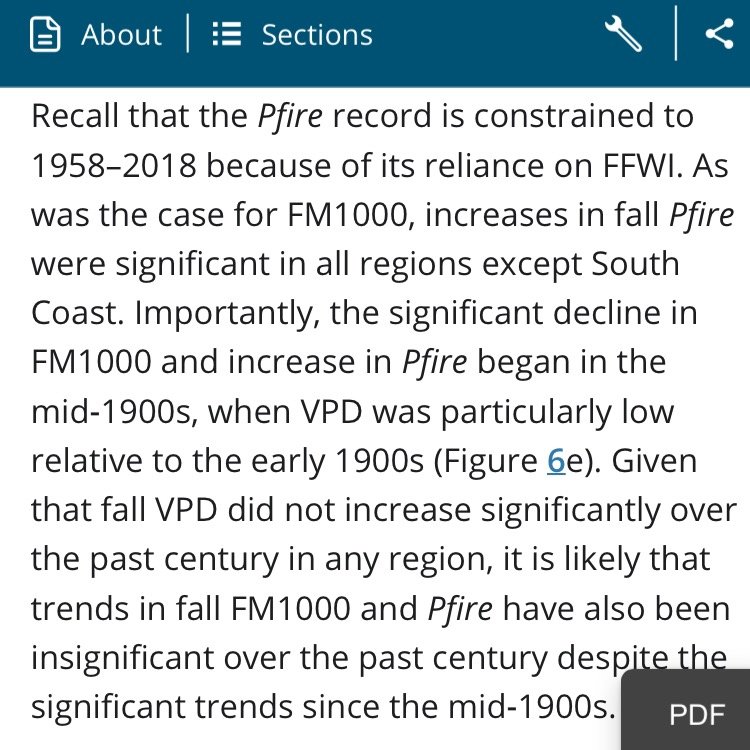
They didn't attempt to quantify the non-climate factors though which was a bit frustrating in reading the study. I just finished reading it and they sort of just decide that VPD fits well enough that it is dominant. That might be true but it would have been nice to try and isolate it from the non-climate factors which they admitted is something they weren't doing in the paper...so we could see numerically how dominant it actually is.
-
It's actually not clear at all for "the current event" given that the autumn attribution is extremely weak to non-existent. It seems the trends are stronger for summer. From the most recent paper you linked: This is the problem with some of the attribution studies that are in a shorter time span. Esp starting in the middle 20th century.
-
Another panel or two and it looked god for some overrunning clipper snows. But yeah...it won't be there next run, lol. The flow is definitely compressed/fast.
-
I actually remember the snow on 9/30/92. I was outside playing and it started as a shower and quickly went to graupel and then some legit flakes mixed in at peak intensity. It was pretty awesome.
-
First snow threat brewing on D10 OP euro? Just need that to stay on for a few more runs and then watch the meltdown when it disappears at 192 hours.
-
Not are about other sites as I haven't checked but DEN is going for all time October records with this cold shot...both record low max and record low min. Pretty impressive. But that doesn't match with climate change. Those types of events are supposed to be less frequent. Not more frequent.
-
EPS are pretty cold 11/7 onward. Coldest look yet. Maybe first flakes watch? Usually our first flakes are some windex or psuedo-windex crap from a deep upper trough. But maybe we can sneak something bigger in like 2012 or last year.
-
That's not even the worst of it either. The best push comes Tuesday/Wednesday.
-
Yeah '96-'97 was active. Lot of teases and some ok events but for those who missed the 2nd December storm, it was mostly rough times until March. SE MA did get the Jan '97 event but they got mostly rain in the advisory snow to ice event inland around Vday '97. That was probably our biggest ice storm between 1992 and 2008 in central MA...pretty solid event. They had nothing though by the time you were at 495. Pretty sharp cutoff on the icing. Left for Sunday River with my cousin and uncle the very next morning...there was like 2-3" of snow OTG with a pretty thick layer of ice on top of it with the ice covered trees absolutely glistening in the sun....by the time we were around Littleton to Westfield to Lowell on 495 on the way up, it was bare ground with no sign of ice anywhere. Stayed that way until we got to Maine and got west of 95...basically zippo in PWM and then Gray Maine had like a foot or more of snow and then by the time we got to north side of Sebago it was well over 3 feet. Couldn't believe the tight gradient in snow pack there. Lol. We had another event in late January '97 that was a bust too. Was supposed to be like 4-7" inland and then maybe some sleet/ZR before flipping back to snow. I woke up at 3am overnight after it had started and saw we already had 3" and it was snowing heavily...felt great about it. Woke up at 7am and it was pouring rain and we had about 1.5" of mush left. Never changed back to snow except a couple flurries. I never really knew what happened until a few years later when I bothered to look at reanalysis and saw that we got swamped by a pretty potent primary in NY state. Guess it was supposed to be more secondary development or better CAD. Still seemed like an odd forecast given the reanalysis.
-
BDL looks like about 19"...so one standard deviation below average is somewhere in the 29-30" range for the season (since average is about 48-49")
-
I had snow pack pretty much the entire month of march 2018...and 2017...and 2015...and 2013...
-
Yes he was. He clarified that a few posts up. So he basically thinks around the 30 inch mark defines a ratter at BOS. Which is fair. That's not a very good season in BOS. One standard dev would be more like 22.5" but we all have different thresholds as to what "ratter" actually means to us. I tend view the term as something more than just a run-of-the-mill cruddy season. Jerry did invent the useage of the term describing seasonal snowfall so he gets more say.


