

ORH_wxman
-
Posts
90,902 -
Joined
-
Last visited
Content Type
Profiles
Blogs
Forums
American Weather
Media Demo
Store
Gallery
Everything posted by ORH_wxman
-
A little pre-season thread: Can Nov. 8 pull off an early win?
ORH_wxman replied to moneypitmike's topic in New England
The spread in the EPS shows the situation well enough at the moment...has some huge hits anywhere from SNE to NNE with some garbage solutions for both and some light to moderate solutions. -
A little pre-season thread: Can Nov. 8 pull off an early win?
ORH_wxman replied to moneypitmike's topic in New England
84 hour 18z looks like congrats powderfreak. Even the chickens are getting pelted at 84h. -
A little pre-season thread: Can Nov. 8 pull off an early win?
ORH_wxman replied to moneypitmike's topic in New England
That's definitely not a "steady as she goes" look....that's a huge bump up in probability for most zones actually with the max stripe being much higher probability and also further north -
A little pre-season thread: Can Nov. 8 pull off an early win?
ORH_wxman replied to moneypitmike's topic in New England
Agreed...I pick Chris' location first in Greenfield for low elevation spot in this storm as the best, but you're area is a close second. -
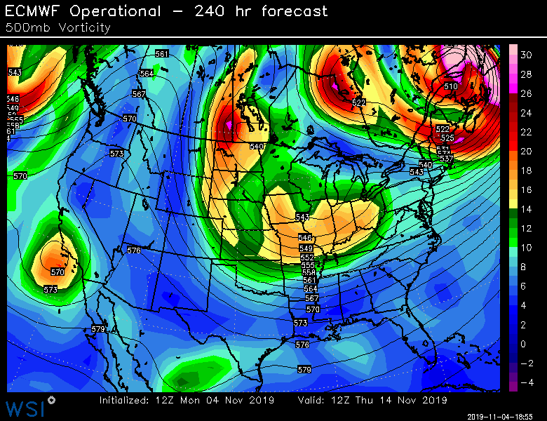
Yeah and even behind it, there's another shot...I almost wanted to see the Euro run to 264-288 hours on this run, just to see what happened to all this stuff dropping down from the plains at D10 even though it's going to look totally different next run....ha
-
A little pre-season thread: Can Nov. 8 pull off an early win?
ORH_wxman replied to moneypitmike's topic in New England
I mean...yeah its possible. This was a pretty extreme solution. But even if the solution is weak, we can still get mostly rain if the frontal boundary hasn't pressed far enough south ala the GFS OP run today. We're really rooting for that scooter streak to hold strong on subsequent runs to get more SNE snow. Most should be happy to just get first measurable....that's the bar I"m setting anyway. If it trends colder/more favorable, then we can start thinking more aggressively. Hope the EPS verifies...just came out and it looks really good for interior SNE into CNE. I think most should know all the caveats when we're in the 90-96 hour range.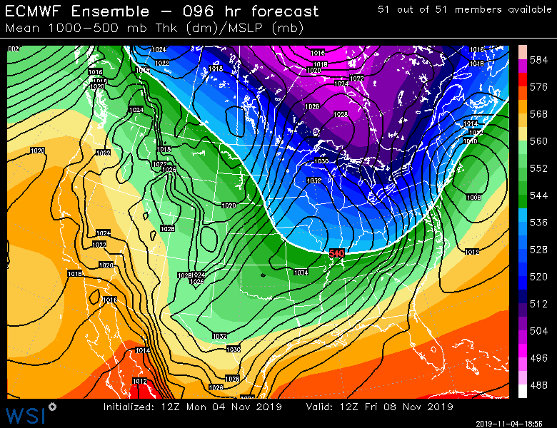
-
And yeah....Euro still hitting 11/12-13 pretty hard. Obviously way out there in clown range, but there's been some multi-model support for something lurking in that time frame.
-
There's some serious cold dropping down next week....if we get a threat for 11/12, I don't think the antecedent airmass will be an issue.
-
A little pre-season thread: Can Nov. 8 pull off an early win?
ORH_wxman replied to moneypitmike's topic in New England
Yeah it's decent when there are some warm layers involved....either at ground or especially aloft. It will punish values over freezing....though it can struggle if the models are biasing too warm near the ground in a paste bomb situation (ala models think ORH will be 34F and snow when in reality it's gonna pound at 31F) -
A little pre-season thread: Can Nov. 8 pull off an early win?
ORH_wxman replied to moneypitmike's topic in New England
Oh I know...so were the 10 to 1 clown maps from earl barker's page in 2007....but we used to post them because it was fun to assume the model QPF would pan out and all of it would be 10 to 1 snow. This is a pretty extreme solution from a dynamic standpoint, so there would definitely be huge totals if the run actually verified. But clown maps just mesmerize the weenie community more into believing it will happen...that's what I always found funny about them. Like if we post snowfall maps, it somehow starts to make it feel more real. -
A little pre-season thread: Can Nov. 8 pull off an early win?
ORH_wxman replied to moneypitmike's topic in New England
Yeah this does go to town pretty quick for CNE/NNE on this specific run...esp Maine....but I'd definitely still fade straight 10 to 1 in early/mid November. If it's showing that type of explosiveness inside of 24 hours, then we take 'em up. -
A little pre-season thread: Can Nov. 8 pull off an early win?
ORH_wxman replied to moneypitmike's topic in New England
There's a reason we have called them clown maps for over a decade. -
A little pre-season thread: Can Nov. 8 pull off an early win?
ORH_wxman replied to moneypitmike's topic in New England
Prob 18-24 for near of just NW of BGR. -
A little pre-season thread: Can Nov. 8 pull off an early win?
ORH_wxman replied to moneypitmike's topic in New England
The northern stream main energy is stornger this run, but the streak is a bit weaker...we want that scooter streak to stay stronger to keep the cold in...so that's what you root for on subsequent runs down in SNE. -
A little pre-season thread: Can Nov. 8 pull off an early win?
ORH_wxman replied to moneypitmike's topic in New England
Coast doesn't get much...they end as snow....this run even has problems for interior SNE, though it's pretty good for N ORH county over to GC/Berks/NW CT. Want it about a tick or two SE in the mid-levels. -
A little pre-season thread: Can Nov. 8 pull off an early win?
ORH_wxman replied to moneypitmike's topic in New England
Yeah its gonna crash the R/S line i think....starts pretty warm in the BL...even ORH may start as a mix. -
A little pre-season thread: Can Nov. 8 pull off an early win?
ORH_wxman replied to moneypitmike's topic in New England
12z Euro looks like it's gonna be more amped than the pretty flat 06z solution....but def nothing like the GFS. -
A little pre-season thread: Can Nov. 8 pull off an early win?
ORH_wxman replied to moneypitmike's topic in New England
Beats what we had 2 days ago when the good solutions were a GGEM/ICON/GEFS power trio. -
A little pre-season thread: Can Nov. 8 pull off an early win?
ORH_wxman replied to moneypitmike's topic in New England
Ukie is still mad flat. Not sure it gives much of anything outside SE areas. -
A little pre-season thread: Can Nov. 8 pull off an early win?
ORH_wxman replied to moneypitmike's topic in New England
GGEM is pretty north too...best for CNE...though it does change to snow in SNE after starting as rain. -
A little pre-season thread: Can Nov. 8 pull off an early win?
ORH_wxman replied to moneypitmike's topic in New England
The Pope has spoken! -
A little pre-season thread: Can Nov. 8 pull off an early win?
ORH_wxman replied to moneypitmike's topic in New England
Prob a good way to view an early November threat. -
A little pre-season thread: Can Nov. 8 pull off an early win?
ORH_wxman replied to moneypitmike's topic in New England
And the 12z GFS barely has a streak....lol...so its congrats powderfreak. Night and day from the Euro. -
A little pre-season thread: Can Nov. 8 pull off an early win?
ORH_wxman replied to moneypitmike's topic in New England
Could be either...but if it's more than 3 inches, it's probably going to turn into mid/upper 20s powder eventually. But it could start as paste or even cold rain before flipping. Still early though....we could still get nothing. -
A little pre-season thread: Can Nov. 8 pull off an early win?
ORH_wxman replied to moneypitmike's topic in New England
What eastern folks want to root for is for both the streak to trend stronger and then main shortwave behind it also to trend deeper....that would probably help this pop into more of a real coastal SE of ACK with cold air already well established.


