

ORH_wxman
-
Posts
90,902 -
Joined
-
Last visited
Content Type
Profiles
Blogs
Forums
American Weather
Media Demo
Store
Gallery
Everything posted by ORH_wxman
-
GGEM looks like a doozy brewing at 144. Euro was close last night but not cigar so interesting to see if it goes a bit more meridional today at 12z...ensembles have been hinting at it though pretty consistently.
-
Areas near PYM and just W and NW actually got a foot in the '89 storm. They were getting enhancement on NE wind. Really frigid airmass. The November 1898 storm dumped 27" even down in New London CT. How's that for anomalous? ORH also had around 2 feet. Frigid storm. Boston had a foot. NYC 6-8".
-
Nov 2000 was basically a shutout. Maybe a few tenths. Cold but not much for snow in SNE. I remember a lot of LES that month though out in Ithaca where I was. We didn't get the monster event that BUF got pre-thanksgiving but a lot of multiband type NW flow events. We do tend to get a 4-8" type event in interior SNE every 3-4 years or so in November. Off the top of my head, we had last year, then 2014, 2012, 2005, 2002, 1997, 1995, 1991 etc. But it's very rare we get multiple such events in the month.
-
NNE elevations and upslope hubs it can be like mid-winter sometimes. Prob the same with lower elevations of N Maine and into the ME foothills. But for most everyone else, it's very tough. Sticking out into the Atlantic modifies things so much. It's often our friend in winter but can be a curse early. It can be like pulling teeth to get a storm track to the southeast of us. I'm always amazed at how few 12"+ storms have occurred in November. I think ORH has exactly 2 (Nov 1971 and Nov 1899)...and that's at 1000 feet in the interior.
-
This one has a colder overall look....but that '71 storm was an absolute doozy. Gave ORH nearly 15" of snow but the jackpot was actually from about AVP-ALB-RUT where over 2 feet fell in spots. The '71 storm was almost a hybrid Miller B. Next week looks like a deeper overall longwave trough and further east. So we'll be trying to pull something in from the ocean more than going Miller B...but things can change.
-
This reminds me of what Tip and I were musing a couple days back when we were discussing how models tend to break down intense EPO blocks (or really any arctic blocking) too quickly in the extended range. On this run, that block is just hanging out north of the Bering redirecting the airmasses down the east side of the North American cordillera.
-
I also have to wonder how the lower level delta-T at this time of the year would be complicating things...if you get something that deep going over bath water, it will just want to go up like a mushroom cloud. Remember how the models struggled with the extremely anomalous PV lobe diving under New England on Feb 14-15, 2015? It was trying to arc the best dynamics well northeast of the actual intense PVA and upper level support but in the end we got that 6-8 hour nuke job over eastern MA/RI. On a smaller scale we also saw that happen on 12/9/05...that was a much smaller upper level feature but it was extremely intense. The vortmax was something like -50/s^2 and when it hit the early December bath water south of LI, it ignited way more than most guidance showed (though the old ETA model back then in its final winter got pretty close to nailing it). Regardless, any time you see such anomalous upper level features, it warrants close attention. Probably both skepticism and attention if that makes sense.
-
More like a PV lobe....but it's pretty unlikely. But it's definitely gonna be really cold and there's a legit chance something forms on the eastern side of the trough.
-
That is a pretty fun solution. Dropping that pv into philly and see what happens....
-
A little pre-season thread: Can Nov. 8 pull off an early win?
ORH_wxman replied to moneypitmike's topic in New England
Stable doesn't necessarily equal better. There were times we would see very fast shifts in guidance and in those cases, the euro would often be slowest to change and last to the party. This usually happened inside of 60 or 72 hours. Boxing Day was a classic example and so was 2/5/16. If there's a fundamental shift in the key data, then a big swing may be warranted. I agree it tends to swing a little more than it used to, but that doesn't mean it's worse. It still probably lags all other guidance in the magnitude of the swings. -
A little pre-season thread: Can Nov. 8 pull off an early win?
ORH_wxman replied to moneypitmike's topic in New England
We've been boiled slowly like a frog into being tricked that we don't notice that day 3-4 back in 2011 considerably worse than it is now. Hell, back in 2007 or 2008 we used to weenie tag people starting a thread for a threat that was 5 days out...now it's pretty rare that a threat makes it to even 4 days out without a thread. And as has been mention ad nauseam, the graphics improvements in the past 5-7 years have been incredible...but that hurts people's perceptions IMHO. We look at pretty QPF maps and snow maps that have been resolved down to 5-10 sq km and it creates this false sense of accuracy when they shouldn't. We used to be more skeptical of QPF and that seemed to create more discussion on the model variables that scored higher like H5 and midlevels. We still discuss that but those maps always seem to go viral everywhere and force their way into the forefront of the discussions. I get it...they look nice and they have some utility, especially when the model uncertainty isn't high...it can highlight favored areas. But in setups (which are frequent) that there is more uncertainty or marginal temp profiles, they can be a distraction. -
There was a huge snow event on January 3-4, 1996 a few days before the blizzard. It actually dumped the same amount as the blizzard in ORH (about 15" from each). There was a sharp cutoff though in accumulations once you got south of HFD-PVD or so....lots of sleet, etc south of that.
-
A little pre-season thread: Can Nov. 8 pull off an early win?
ORH_wxman replied to moneypitmike's topic in New England
Yeah modeling is definitely better than 5 years ago. People just demand more from the models and the data is also available in every form and every map for every weenie to look at and I think most are supposed that they actually aren't right verbatim quite frequently. -
A little pre-season thread: Can Nov. 8 pull off an early win?
ORH_wxman replied to moneypitmike's topic in New England
Yep. The leading shortwave up in Quebec (aka the Scooter streak) that was out ahead of our main player was stronger innthe runs we saw a couple days ago. That established that cold boundary...as you said, probably somewhere south of LI over to south/central NJ and we were seeing the "NJ model" type cyclogenesis on some of these solutions as the wave moved off the coast....since then, our leading shortwave which presses the boundary south has gotten weaker and we're kind of almost straddling the boundary ourselves now or maybe just a touch south. That's not gonna get it done...esp in November. We might get away with it in January when antecedent climo airmasses are much colder but not now. We will definitely want to see a reversal in that trend pretty soon if we're going to entertain the idea of shovelable snow. -
A little pre-season thread: Can Nov. 8 pull off an early win?
ORH_wxman replied to moneypitmike's topic in New England
Euro def flatter. I have doubts that this will track into interior SNE like those GFS runs yesterday. Biggest problem actually might be the BL. We don't establish much BL cold before it moves in. -
A little pre-season thread: Can Nov. 8 pull off an early win?
ORH_wxman replied to moneypitmike's topic in New England
Yeah at this point you'd sell the rpm. It's solution isn't crazy but we need to see the cold press come back more on today's runs to give it a little more support -
BOS average first measurable is 11/29 but if you go by first inch, it's 12/11.
-
A little pre-season thread: Can Nov. 8 pull off an early win?
ORH_wxman replied to moneypitmike's topic in New England
First RPM request of the season. Lol Here it is...not quite done yet at 72 and most of the event still to come in Maine.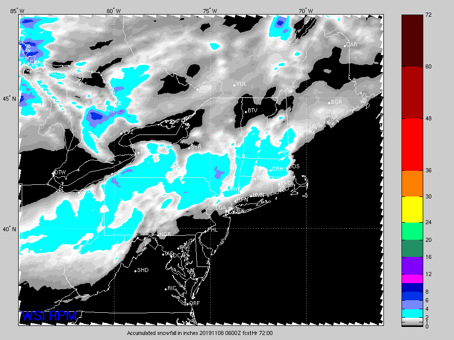
-
Yeah that pattern being shown from about Veterans Day to the 15th or 16th has a lot of potential. Heck even behind that the PNA is trying to reload a bit so we may get more shots later on. All you can realistically ask for in November. There's a reason even a place like ORH averages 3.5" in the month of November. It's a tough month...but we actually have some stuff to track this year.
-
On November 5th. Mark it down. First melt of the season.
-
A little pre-season thread: Can Nov. 8 pull off an early win?
ORH_wxman replied to moneypitmike's topic in New England
So what are we down to now? Rpm still shows a decent snow event. Did we lose the World War II suite? -
A little pre-season thread: Can Nov. 8 pull off an early win?
ORH_wxman replied to moneypitmike's topic in New England
You know in winter when we need the Scooter streak to weaken, it won't happen like this event where it weakened almost every run from 48 hours ago. -
A little pre-season thread: Can Nov. 8 pull off an early win?
ORH_wxman replied to moneypitmike's topic in New England
18z Euro is coming in a bit flatter through 72h. So it's prob not gonna be the wild solution that 12z had. -
A little pre-season thread: Can Nov. 8 pull off an early win?
ORH_wxman replied to moneypitmike's topic in New England
It's a shame too. They used to be good or at least serviceable. But they lost their mojo in 2013 I think when they got rid of the ETA and then RSM members within like 12 months of each other. All i remember them for now is when you kept posting them in Jan/Feb 2015 when they would show a BTV jackpot and all other guidance was burying Scooter. We all pictured you using them to sooth the soul while downing your last bottle of scotch...lol. -
A little pre-season thread: Can Nov. 8 pull off an early win?
ORH_wxman replied to moneypitmike's topic in New England
As dendrite once said....the icon is a key component of the the WWII ensemble.


