ORH_wxman
-
Posts
90,902 -
Joined
-
Last visited
Content Type
Profiles
Blogs
Forums
American Weather
Media Demo
Store
Gallery
Everything posted by ORH_wxman
-
That's kind of how last year happened. Storm came up the coast in a moderating airmass...but models initially moderated it too quickly and as we got closer and closer it turned into a big front ender.
-
Ensembles are actually trending toward a reload in the 11/20 timeframe after a relaxation for several days. So hopefully that happens and we get another round of threats late in the month.
-
It looks a little more organized than yesterday but I agree it's still more of a frontal wave. It's not a stemwinding cutter going due north or NNE from Birmingham to BUF.
-
Yes. But that unfortunately is usually going to be the case this early because it's hard to have cold entrenched for more than a day or two this early and still support snow. It becomes a bit easier later in the month. Still, at least we've had a shot on some of these unlike many Novembers where we are waiting for the euro weeklies as our only real model interest.
-
Yeah the trend has been strong the past 24 hours. We'd need to see a fundamental shift and reverse that. Still possible but unlikely. It's too bad because the airmass on the NW side is legit.
-
Yeah this one is rapidly trending into a cutter.
-
A little pre-season thread: Can Nov. 8 pull off an early win?
ORH_wxman replied to moneypitmike's topic in New England
Snowing on WaWa webcam now -
They are permanently scarred from when Scooter had a higher snow depth for weeks than Stowe village has seen in the past 4 decades.
-
A little pre-season thread: Can Nov. 8 pull off an early win?
ORH_wxman replied to moneypitmike's topic in New England
PSF has flipped to -SN. Might see some snow in N ORH county within a couple hours or so. -
Tday high last year at ORH was 16F. A cool 29F below normal and 4F colder than any November max on record. (Previous record was 20F on 11/30/58) That was a pretty incredible airmass.
-
A little pre-season thread: Can Nov. 8 pull off an early win?
ORH_wxman replied to moneypitmike's topic in New England
Yeah it is always nice to see the first widespread snowfall in the area even if it misses us north. Usually that's the way it works. Picnic tables first and then a nice widespread event for all elevations of NNE. -
That was an incremental improvement on the Euro for the incrementalist weenies.
-
That's been pretty constant regardless of where exactly the storm tracks....brutal cold next Wednesday. Unless there's a pretty significant moderation, that's gonna obliterate some record low maxes and prob record low mins....esp if we can get some snow cover.
-
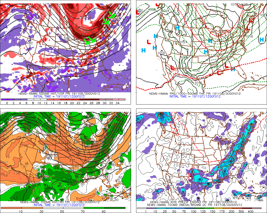
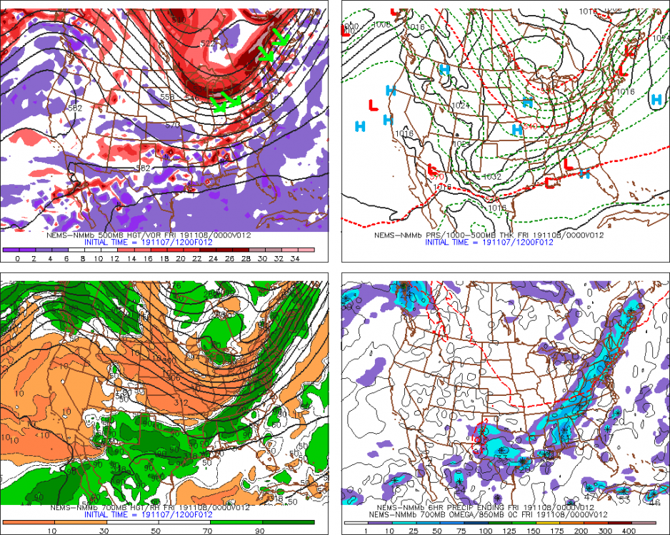
At any rate....keep an eye on the trough axis for the next threat...that will be a huge key. The 12z GFS has shifted east vs the 06z and 00z runs.
-
LOL at some of the rhetoric in here...today's event really isn't that far off from a decent early season event over the interior. Yeah, it didn't pan out for most (I'm sure Mitch will get several inches in VT, for example), but lets not pretend that this should have been handled as some complete model guidance mirage from 4 days out....there's a reason we don't lock stuff in from 4 days out, but it doesn't mean dismiss it either because it's anomalous. Remember all the clowns who dismissed the October 2011 storm even 2 days out? Some of them were TV mets too. (but not our own Ryan Hanrahan) Just to demonstrate the main piece that were different in the snowier scenarios....the streak of energy north of Maine was pressed a bit further southeast on the previous snowier solutions....and that in turn, forced the lakes energy a bit southeast as well as make the overall temperature profile much colder over New England..... BTW, I agree with Tip that the GFS beat the Euro this time around from about 4-5 days out....neither was correct, but the GFS was closer. The Euro also had a pretty classic burp run that one solution where it was dumping 20 inches on the chickens....that should have always been viewed with skepticism and I think most here did view it that way. But as for a run-of-the-mill advisory type snow, we actually weren't that far off.
-
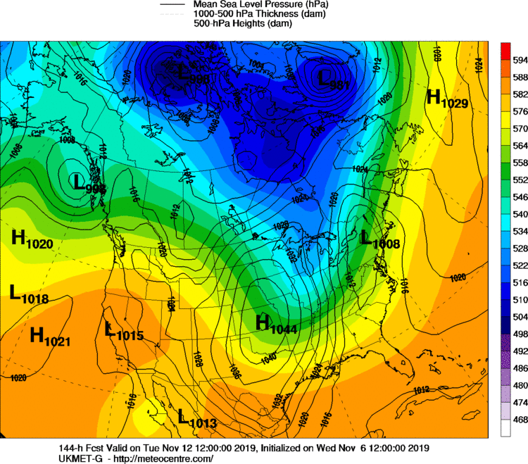
Yes. The western ridge position has shifted further west on the most recent runs of the euro and EPS versus earlier. It is all being driven by the EPO block orientation. Sometimes the EPO can "fold over" and it acts as a big PNA ridge which keeps a cutter threat to a minimum...but other times the EPO block will hold where it is and the flow will buckle back to the southwest and the cutter threat increases as the ridge and trough axis are west. Both scenarios still on the table but that is why we saw the hugger showing up today.
-
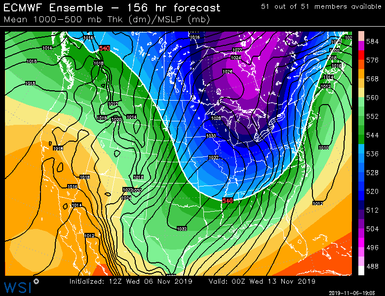
Anyways...worth watching. Here's EPS mean at 156. Plenty of spread too...
-
Yeah it would probably given an inch or 3 at the end with a flash freeze. Nothing wrong with that for the winter enthusiast on November 12-13.
-
Fade is actually a gambling term I used to use all the time back in the day during my blackjack excursion lifetime....but didn't really apply it to weather. It has become more mainstream now given the popularity and legality of sports betting. So yeah, it seems it's been picked up here, lol.
-
If you ignore the hugger the Euro had....lol
-
You might get your shot this year.....esp if its a shallow pond....if things work out "favorably", then it could be like 5+ days straight struggling to get above 35F or so with very cold nights. If we can somehow get some snow cover next Tuesday first, then it would be even a bit colder. I'd obviously fade those chances at this range, but there's potential for pretty intense cold that lasts more than just a day or two...maybe reload in there somewhere too.
-
Yep, there's a lot of Novembers we don't sniff a single decent threat. But this year probably has everyone particularly antsy because we get the usual long wait from the summer, but it comes on top of last November when we had a widespread warning snowfall in the middle of the month. Pretty rare occurrence. This next threat has a legit airmass provided we get on the correct side of the low....so it's going to be almost exclusively about where the trough/ridge axis set up in response the EPO block and shortwave coming down the east side of it. It has high-end potential because of the deep meridional flow for this time of the year....usually in November we're struggling to get the PJ that far south. But at the same time, it's still a bit of a needle-threader because we need to push the front offshore but not too far as to suppress the system. If we don't push the front far enough, then we risk a cutter or interior hugger. But if this next one doesn't work out, there's yet another one behind it as you mentioned. Multiple shots here in this pattern.
-
For the cold and dry weenies....record low maxes would get obliterated next Wednesday if that verified.
-
Potential is there....details TBD. There was a fundamental shift in the longwave ridge axis out west this run...it was a solid 500-700 miles west of the 00z run which is why we get this hugger potential....and probably why the Ukie actually showed a cutter. That type of a shift is a big deal. But a lot of what is driving this is still in the arctic....this is the result what is going on with the EPO block. So I'd expect some swings until we get closer.
-
Here you go.....12z Ukie has BIrving's cutter