ORH_wxman
-
Posts
90,902 -
Joined
-
Last visited
Content Type
Profiles
Blogs
Forums
American Weather
Media Demo
Store
Gallery
Everything posted by ORH_wxman
-
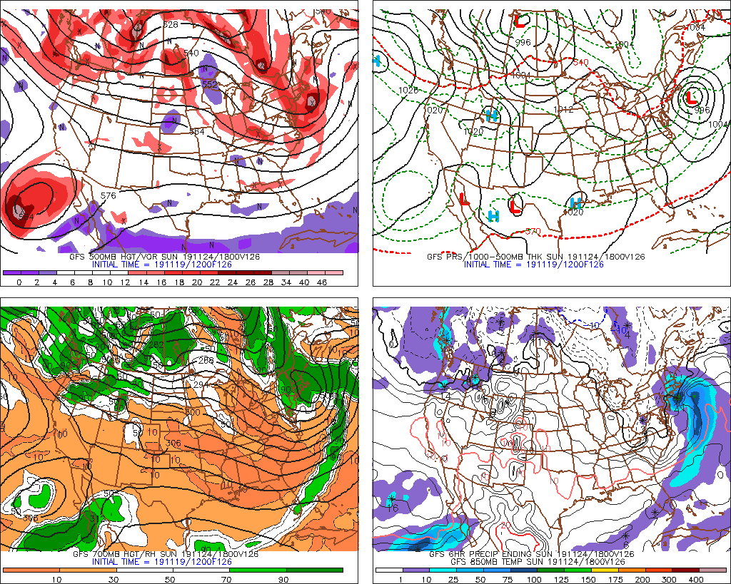
Yeah if that upper air solution actually verified, I'd expect a lot of SNE to flip to snow actually. It would probably trend colder in the MLs as we got closer...it's probably flushing the fresh -10C 850s we get 18-24 hours earlier a bit quick too as an aside from the dynamical cooling aspect...or at least not allowing that drier mid-level air to hang tougher.
-
It's a very dynamic solution aloft...that would honestly probably be enough to flip a lot of people to parachutes. Of course, its' also 5+ days out...so I'm sure it will hold serve...
-
That's really close in the interior of SNE....its like between 0-1C isothermal at 18z Sunday.
-
Northeats of you....ORH hills down to NE CT/NW RI.
-
Yeah the IVT tries to blow up a bit before it moves east...may need to watch for a little burst on the coast late tomorrow PM into evening.
-
Euro tries to give the interior hills a weenie inch or so tomorrow.
-
I'd def rather have it a bit SE at this time range than NW with the marginal airmass in place and not a ton of confluence. Hope it trends stronger into a hit...that would help with dynamic cooling as well.
-
Yeah Ukie and GGEM are whiffs...but worth keeping an eye on....there's enough cold for some snow over the interior anyway....maybe to the coast like the GFS has.
-
We knew you'd embrace the GFS eventually
-
Gonna want the mid-levels to develop like this or better
-
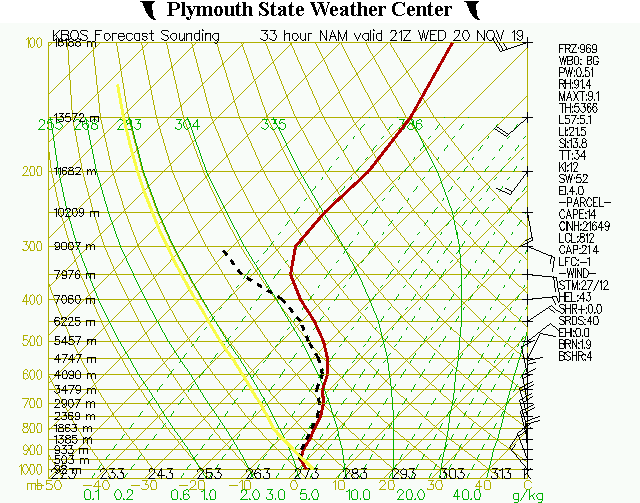
Here's the BOS sounding tomorrow afternoon...
-
Dont' be surprised at a lot of weenie snow around tomorrow....soundings look pretty decent.
-
New Years 2018 was pretty good.
-
A lot of our best Decembers didn't have a great PAC pattern. 2007, 2002 (interior), even 1995 was so-so....amazing NAO block though. Kind of weird actually. I'll have to make a composite of the top 10 decembers and see if that holds when I add in all the other good years.
-
Right...but your "big storm" bias is showing here. Who said anything about "crushed"? It wouldn't take that much for like a 3-6" advisory type over the elevated interior. Is it favored? No. But we can't rule it out.
-
It prob plays into the subconscious bias...I've seen a lot of marginal setups work out in the interior over the years. Obviously near the coast it doesn't happen as often.
-
It's admittedly an uphill battle...but there's this shot of brief (but real) cold on Friday night/Saturday. So if that can set the stage enough...we could pull off something over the interior. The storm itself needs to be a little better organized too.
-
#ineedahug
-
Euro is legit close to snow over interior on sunday morning. I wouldn't totally give up on that one yet.
-
Slight nitpick....but BOS had 23.1" in the Feb 7-9, 2015....so not technically two feet. Though they probably slightly under measured according to most of the obs around them.
-
Not sure if one of the theadex type sites can do it....Chris has a link to a good one that isn't just the extremes. I don't have the averages for BDL for 12"+ storms. For ORH, since 1950, there have been 80 events of 12"+....but obviously some winters go without one. So in those 69 winters, 44 of them had at least one 12"+ event. That means 25 of them did not. So if you go by the binary "yes" or "no"....then the probability of getting at least one event would be 64%. BDL is a significantly worse spot for big storms than ORH, so my guess is the odds would be somewhere around half of ORH's. Maybe a bit more....like 35-40%. I know this information is available somewhere in the climate normals in the NCDC (now NCEI) probability sections, but I cannot navigate that disaster of a site anymore. Not user-friendly at all for finding those values.
-
Glad we don't live there
-
I had to miss the snowfall that morning...I was torching down in NJ....but we came home to a fresh 5.5-6.0"....and bitter cold. It's definitely been a bleak streak of white Xmas's around here....for ORH which averages about 60-65% chance for a white christmas, here's the past 10 years: 2009: About 7" pack...mostly from the 12/19-20 storm that really crushed SE MA 2010: About 2" mostly from the retro storm on 12/20-22 that got the Cape with a foot 2011: Bare ground 2012: 1 inch of fresh falling snow that morning....last second rescue as model guidance was kind of meh on the snow. But then it started falling predawn and lasted 3-4 hours. 2013: Swiss cheese pack of about 2-3 inches that survived the grinch storm leftover from the big snows that fell between 12/9-12/17 2014: Bare gorund 2015: Bare Ground 2016: Patches....but counts as bare ground...i think 2-3 inches survived up by Hubbdave 2017: Xmas morning 4-6" on top of about 2-3" leftover from earlier 2018: Bare ground So we've gone 4 out of the last 5 with bare ground or mostly bare ground. Pretty bad...and even 2013 wasn't a clean pack, and 2012 had to be rescued by a fluffy inch. We had a good run in the 2000s....between 2000-2010, we had 8 out of 11 (only 2001, 2004, and 2006 failed)
-
Probably but it's not impossible to get something next Sunday. GFS/GGEM were fish food while Euro was too warm....something in between is what the Ukie is going for.
-
Were you sleeping during Christmas 2017?