ORH_wxman
-
Posts
90,902 -
Joined
-
Last visited
Content Type
Profiles
Blogs
Forums
American Weather
Media Demo
Store
Gallery
Everything posted by ORH_wxman
-
Oh yeah....i didn't mean the eastward PAC shift will stick. Some of that Atlantic stuff is going to effect the Pacific side too. Regardless, the PAC improving (EPO ridge building as we go into December) seems to be consistent. We just don't know the exact orientation yet. Ideally, we'd get an NAO block to stick around for a couple weeks, but we know how those go...and I wouldn't expect models to have a good handle on it either. There should be plenty of cold around though....especially after the cutter in early December that causes a bunch more folks to melt down here, lol.
-
The eastward shift in ridge placement out west is a good sign. We'll want that. Esp if the NAO ridging is transient.
-
Really volatile ensemble runs with the NAO...not a huge surprise, but that is gonna be a factor in how December starts. The PNA has been rising on recent runs too.
-
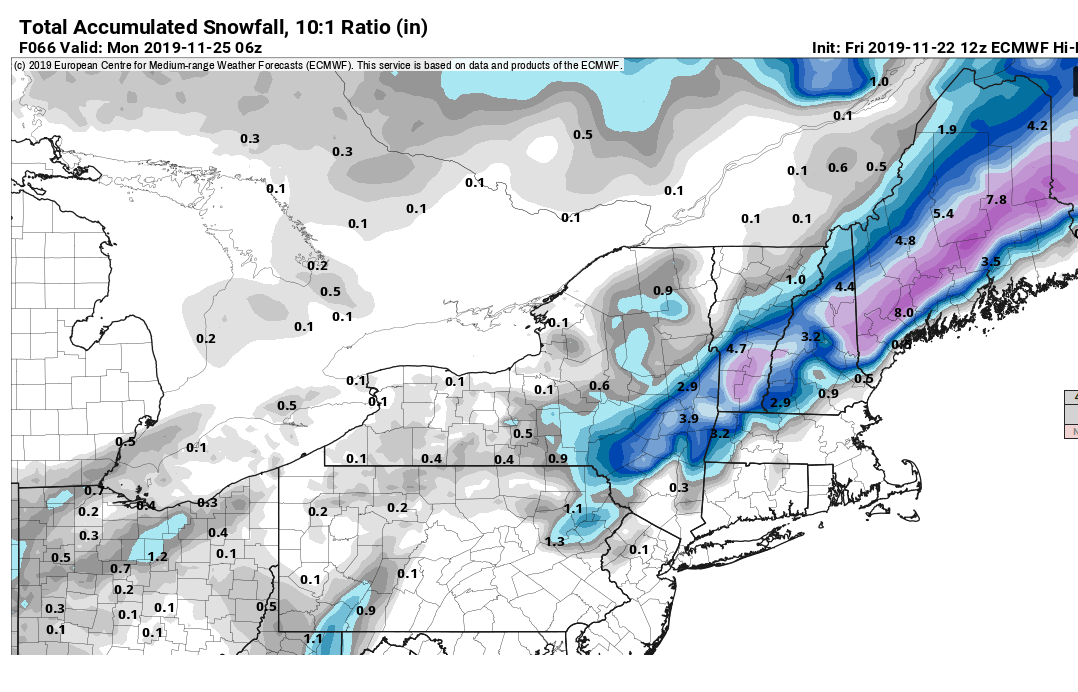
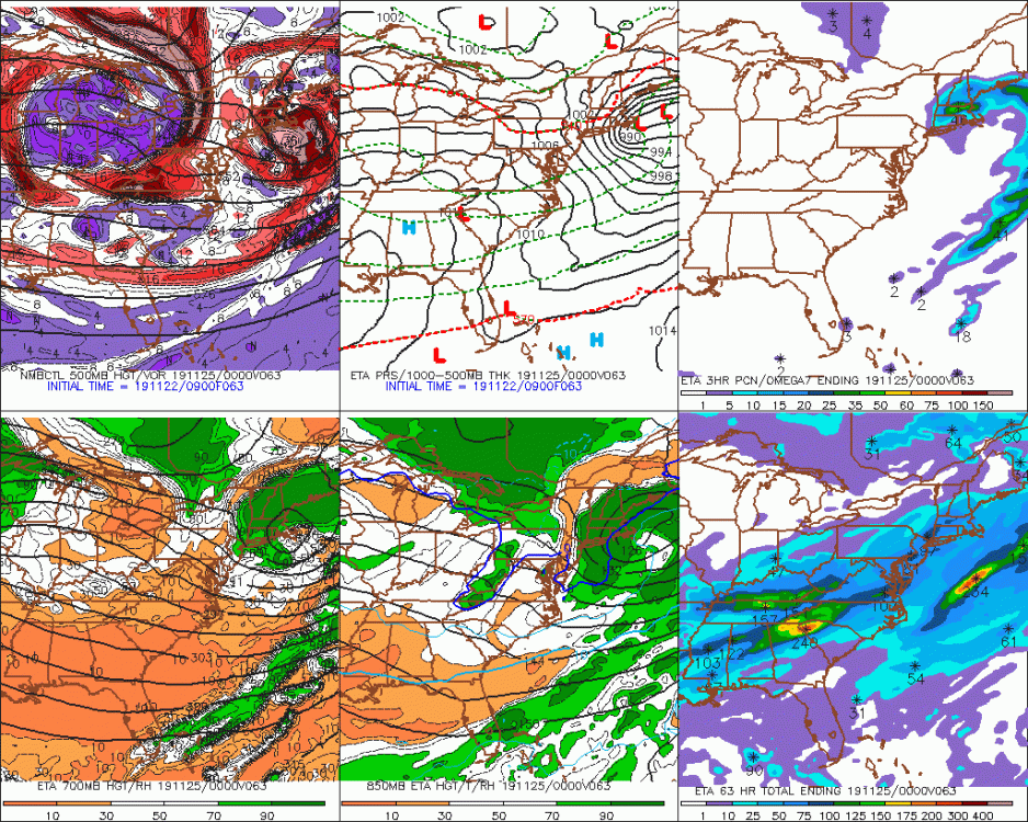
Yeah here is the pivotalwx clown map...def trying to up the threat for Monads into S ME. I think these maps are probably more useless than usual though in a setup like this....it's going to be all about omega really. I think some of this is probably rain before the flip but the algorithm assumes that if the 3 or 6 hour period ends as snow, the entire LE during that period is snow too.
-
Sweet....December starts on Nov 22nd now!! Always liked the longer Christmas season.
-
It's mostly voo-doo...it's kind of a bummer that we're like 1-2C short of a big paste bomb....but on the other hand, you'd have some debbies probably complaining if we weren't getting coastals saying "this is a bad sign for the winter".
-
Agreed. We may also get 45 inches of snow this December too.
-
Yeah I mean, there's no reason to buy the potential right now....it's worth keeping an eye on over monads and ORH hills and maybe up toward dendrite and interior southern Maine....but a lot needs to happen for it to work out. Model guidance has subtly been shaving the temps the past 2-3 runs....really slowly, but it's ticked slightly colder. If that continues up until go-time, then it could get pretty interesting. The problem is that it could easily just stop trending that way. The Oct 18, 2009 event actually did this though...looked like rain and then it ticked colder the final 24-36 hours just enough to get ORH hills into the game, and then during the actual storm, there was the Foxborough omega-bomb surprise that wasn't predicted. I'd feel a lot better about it if we had another 1C right now in our pocket....it's a tough task without it.
-
No, I think he's talking about March 2010....that's when I had the meltdown anyway. The Mar 2018 one was pretty brutal too...barely too warm...but at least we got buried back to back shortly after that one.
-
GFS cooled a couple ticks for Sunday...that would probably be flipping to heavy wet snow over the interior before ending. But yeah...as Scooter said...man, if we could shave even another 1C or so off this, then it would really be interesting.
-
ORH hit 0F that day...last day that was 0F or colder for a high. Jan 1994 and last January had a 1F high. 2004 had a couple 2F highs I think.
-
'80-'81 never got good...except for a brief headfake on 11/17-18 with the solid November snowstorm....but then it just got cold and mostly dry. When the pattern got wet again in February 1981....we absolutely furnaced and most of the precip was rain.
-
I morbidly want 1976 to repeat itself....just to watch the hilarious meltdowns....early December 1976 had a historically cold airmass around Dec 2-4 after a frigid (and relatively snowless) November....2 days later, a massive rainstorm with 2 inches of rain happened...lol. Then right after the rainstorm, highs were in the teens. The season eventually ended up pretty good...esp for eastern areas, but the frigid and relatively snowless conditions early on would be a hoot on here. We kind of got a preview of that in 2010-2011....we had cold and then a few cutters mixed in early on and there were some people melting down. But they whined their way to a 3 foot snowpack a month and a half later.
-
Go with NMM
-
Sudbury is def a good CAD spot...good rad spot too. You go like 3-5 miles SE into Framingham and Natick and it can be totally different.
-
'80s were loaded with +PNA too....so there's still plenty of times we get both and it doesn't work out. It's because in order to get a year like 2015 where we have a raging +NAO, you need that PNA ridge in the perfect spot...which it was for like a month save a brief reload where we got lucky anyway on Feb 7-9. A decent NAO will allow us a lot more wiggle room...we won't be obsessing over the ridge placements. Take 2010-2011...we have all kinds of -PNA and neutral PNA, etc, etc....but that Davis Strait block allowed the wiggle room.
-
Heh, the 1980s had plenty of -EPO years that were garbage.
-
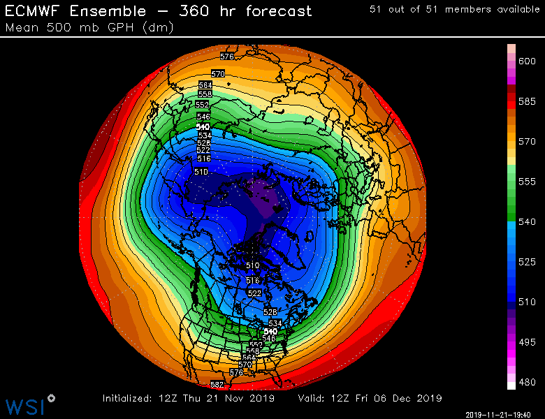
December starts with a -NAO and then it looks like it weakens as we go deeper into month. But EPO builds. Who knows though...esp WRT NAO. Those blocks can be really nasty to forecast the timing of.
-
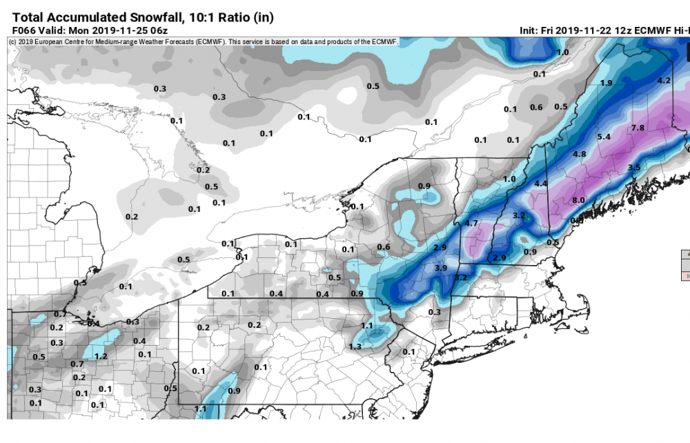
06z euro got a little colder. Approach the system with skepticism but still keep an eye on it.
-
GFS is pretty interesting too.
-
That was kind of an interesting solution. Nearly isothermal paste for ORH hills to NW CT.
-
I'll bet 2009-2010, 2015-2016 (mega-blizzard basically gave them their seasonal climo), and 1963-1964 were huge factors in the midatlanitc....all were furnace Novembers (top 10 all time) and none of those years were great up here with '15-'16 being putrid. Of course 2009-2010 was obscenely good down there.
-
Here is the map zoomed in
-
Ha...there was no way it was going to be as zonked as the GEFS....but it is a very good look. They do both agree on good EPO ridging. The GEFS just took to the extreme for a D16 prog.
-
The good news is we continue to have no scooter meltdowns with the long range look....today's EPS looks very good for early December.