ORH_wxman
-
Posts
90,902 -
Joined
-
Last visited
Content Type
Profiles
Blogs
Forums
American Weather
Media Demo
Store
Gallery
Everything posted by ORH_wxman
-
Thermals aren't really different through 36 but qpf is more meh on the front side.
-
Ratios in any Monday night/Tuesday deal going bonkers would prob be really good (like the NAM scenario)...of course, believing a "bonkers" scenario actually happening is an entirely different debate.
-
The guy who said "it's beautiful!" In raiders of the lost ark was French...is that a good or bad omen considering what happened next?
-
No not this early. You have last year and October 2011...that's it. Nov 2012 did have 6"+ for interior elevations but it wasn't that widespread. Nov 2014 was a smaller area in SNE over 6". (Basically just Berkshires and ORH hills) This is also a lot higher end too than last year or Nov 2012/2014. There's potential for some pretty big amounts of it goes well.
-
Yeah it is easy to forget how damned early it is. Getting widespread 6" and a pretty decent area of 10" would be pretty amazing for this early in the season.
-
That's a pretty nice look even in BOS late Monday night.
-
Looks like it tickled slightly east and colder from 06z.
-
Dec 6, 1996 would have shown 10.0" and Dec 7 is 16.3"
-
Caveat that 1996 is not in that database.
-
Ukie def trended east for Monday night. That 60h panel had the low pinned against NYC on the 00z run at 72h.
-
Surprisingly it looks a lot more reasonable for that WCB. Usually it's the other way around but the regular RGEM is unhinged on the QPF with that.
-
Clown maps didn't even exist yet when I started forecasting. They aren't needed...using QPF and then massaging it based on the other features like midlevels and thermal profiles will get you where you need to be. 10 to 1 isn't a bad place to start but often you need to cut back on the qpf itself...once in a while you adjust upward of it's a really nice midlevel magic look.
-
Off top of my head: 1. Dec 11-12, 1992....32.1 2. Dec 23, 1997..........18.0 3. Dec 23-25, 1961.....17.6 4. Dec 7-8, 1996........16.3 (right after 10.0 fell on 12/6/96...these are not officially counted as one system) Not sure which would be #5. There's a bunch in that 13-15 range. I'm a little surprised I couldn't think of another one over 20" but I'm pretty sure that's it for December.
-
Just the tropical tidbits maps. Most of the others are smart enough to exclude sleet. But they should still be taken with a grain of salt.
-
GGEM tickled a little colder too. Still has that insane WCB on the front end kind of like the RGEM does.
-
Best stuff on RGEM for CCB looks like NH and NE MA. Though it does have some stuff in CT but It's mostly western CT and then up into far W MA and NY st. Central and eastern CT kind of end up in a hole.
-
Coming out right now. Out to 18h
-
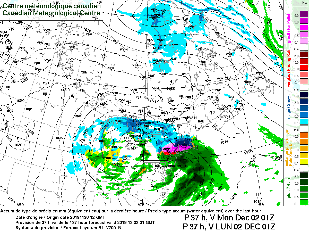
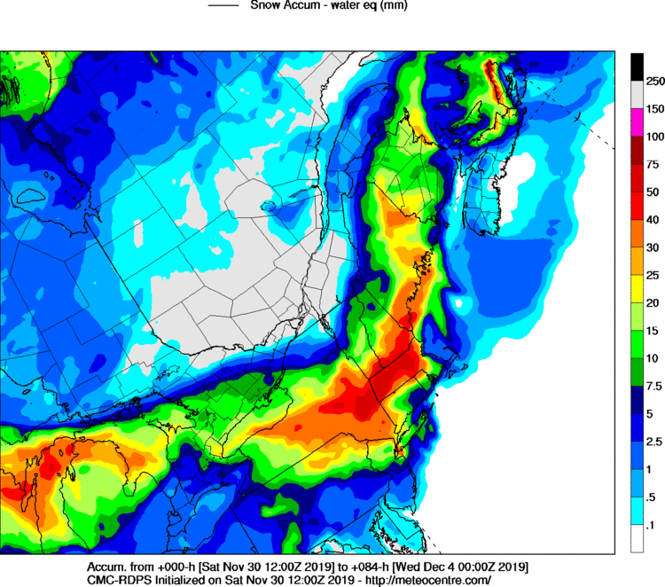
RGEM on meteocentre...for the pike crowd, save it...all downhill from here
-
Yeah...5" might be ok as a floor N of 84 because they might actually get 3" of sleet/pixie dust (with the pretty cold 875-950 layer) on top of whatever falls as snow the first 3-4 hours. Then there's the ULL stuff obviously which is a wildcard. For just the front ender stuff though, I could see justifying 3-6 or 4-7 N of 84 but south of border. Not an easy forecast though. It seems like if we could get one shift in either direction it would make that pike to HFD zone a little more clear cut.
-
Wouldn't be surprising if there's big aggregates trying to take over the pellets during the biggest lift and then it goes back to a peltfest during that 00-03z timeframe. Even the NAM (not 3km) has a very marginal warm layer at BDL looking at the soundings and it's way up at 750mb. Throw some monster lift up in that zone and it gets washed out.
-
Might want to try and get out late Monday afternoon instead. Monday evening could start snowing again in Boston if things go "correctly" with the ULL. It's prob not until later Monday night there but if you want to be safe I'd try and go out Monday afternoon during the drizzle dryslot.
-
Looks like it flips HFD around 23z after about 3-4 hours of steady moderate snow. But it rots near BDL for an extra 2-3 hours. Like heres 01z...

-
The RGEM absolutely annihilates MA on the front end thump. That will be good entertainment when the meteocentre maps come out. Hits N RI pretty hard too.
-
Yeah if that sinks just a hit further south or southeast, then he's in good shape.
-
3k only goes to 60 hours.