

ORH_wxman
-
Posts
90,902 -
Joined
-
Last visited
Content Type
Profiles
Blogs
Forums
American Weather
Media Demo
Store
Gallery
Everything posted by ORH_wxman
-
Oh yeah...the 1997 event would have shown up yellow even on the old garbage radar. Nevermind the bright reds on the Doppler. That one is in a league of it's own for intensity.
-
It was the 88-D by then. I think when NWS consolidated to Taunton, by 1995 they had the 88-D installed there. IIRC they brought the old radar and used that for a year after the consolidation? I think the consolidation happened in mid/late 1993 but I distinctly remember the old crap radar still in the '93-'94 winter.
-
Yeah those were the old WSR-57 and WSR-74 radars before all the 88-Ds had been installed. Getting into that dark green shade was really hard...you're right. I remember doing it in one of the 1994 storms but it was very fleeting. Lasted like one or two frames.
-
TWC was the only way we all got our fix between local news back then. There was no real internet weather. Even once in the dial-up days by the mid-1990s, there wasn't anything in real time....satellite and radars were like 30 minutes behind if you even got them to load on your 28k bps modem.
-
Winter 2020 New England Banter and General Obs
ORH_wxman replied to CapturedNature's topic in New England
Full on winter. Clouds really limiting the effect of the weak December sun
-
Didn't the PNS have BOS at 7.1"......their F6 and CLI data shows 5.9" for the storm.
-
No, I said most of it fell in 3 hours. Prob about 7" of it. No, never flipped to sleet amazingly. I thought we were going to but it just dryslotted and even the cruddy echoes in the dryslot were crappy flakes with no ice pellets in there. We may have had a bit of freezing drizzle though in the dryslot during the lowest returns with the SGZ dried out. There was the finest glaze yesterday morning...like it wasn't enough to produce a crust on the snow but I noticed a hint of that "bumpy" ice feel oknthe metal railing outside.
-
Just under 17 total. Got crushed in round 1 with 9.5, with most of that falling in about 3 hours. Then limped to about an inch yesterday with mood snows most of the day with a few brief moderate bursts. Then had a quick 6 this morning.
-
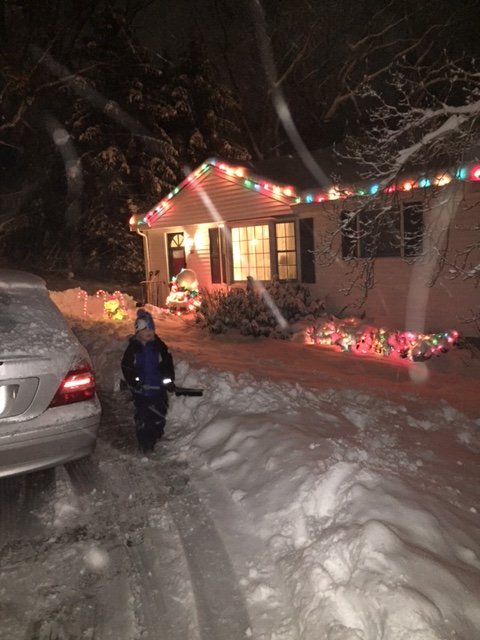
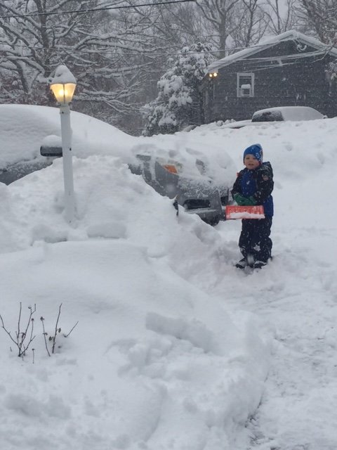
A couple pics for powderfreak....first one is last night of my son helping me clean. The second one is this morning helping me clean again...lol. He's becoming a huge snow weenie
-
Yes.
-
Dec '92 was December 11-12....that one was bigger....though this one spread more goods to the CT river valley than that one did.
-
There's some truth to this....I rememeber talking in an exchange with dendrite a couple days ago about the obscene mid-level inflow. I was starting to worry about a firehose and that we might have some monster totals. We never totally got the Mar 2013 look (though for a time it started to look like that last night), but we didn't need to get it to have a big storm because this moved so slow and had a better wrap-around ML structure this morning than that storm. Never give up when you have a potent ULL going at that latitude underneath us.
-
Departing birthday present for Jerry....prob some fatties falling in this
-
Needs a lot of work to get to that point.....but still 6 days out.
-
I'd watch early next on the colder trend....I'm kind of with Tip on this one. The PNA is actually spiking during this time with an EPO block already in place....this is going to want to negate the rising heights out ahead of the storm system. We even have a weak greenland ridge too. As Tip would say, the "correction vector" is colder. Now that doesn't guarantee we don't cut...the individual shortwaves can overcome the background teleconnection....but it could turn into one of those flatter triple point deals where we maybe barely warm sector.
-
It is nuking perfect dendrites in these heavier elements.
-
HRRR doesn't shut off the steady stuff for E MA until 18z and it lingers residual mood snows into late afternoon.
-
It really comes down when these convective-looking elements move overhead.....obscenely good snow growth....this stuff is gonna be like 20 to 1 blower after all that dense snow we got Sunday night.
-
Wow we got into a nice band just a while ago. Went from dryslot to like 3" overnight and snow still backing in up to the northeast.
-
That list is only December.
-
Yes, you'll get some more....prob another 1-2 would be my guess.
-
I dunno....you ended up with an inch of glop last night that washed away while throwing a tantrum and I had almost 10 inches. The empirical evidence isn't on your side this time. OTOH, Ray did bitch and whine his way to 11 inches. So guess it can work both ways.
-
I"m choking on Scooter exhaust right now. This is what I get after last night's epic blitz....lol. Can't complain too much with between 10-11" now and mood snow falling. Still hoping for 2-3" though later as the bands rotate back down later.
-
No...this is weather....you are required to stay in the snowiest spot.
-
Been mostly dryslotted recently, but have managed to pick up an inch or so since morning. Hoping for that stuff moving NW on the Cape to reinvigorate the banding a little further east.....HRRR and RAP don't look overly promising....but then again, they've been jumping around a bit seemingly every hour on this. It's been very light snow the past 2 hours....


