

ORH_wxman
-
Posts
90,902 -
Joined
-
Last visited
Content Type
Profiles
Blogs
Forums
American Weather
Media Demo
Store
Gallery
Everything posted by ORH_wxman
-
Powderfreak organizing the skimming competition for next week?
-
CT didn't get much of anything in 2008 except for the highest spots of Litchfield county. N CT had a pretty good one in early January 2005. I think it was 1/6/05. They also had the 11/17/02 ice storm. More elevation dependent. Id say parts of the state did pretty well on 12/23/17 as well.
-
If it starts looking more like the 06z euro then it might yet still achieve that look.
-
Agreed.
-
Too early to really get that specific about next week. Could be a classic SWFE where we get advisory snows followed by some sleet and ice but accretion isn't a big deal....or maybe it ends up a bit icier. I don't think it would be a big time ice event with the speed of the system. It's mostly in and out in about 12-18 hours. The shortwave gets sheared apart which tells me this will not be that big of a deal. Maybe that changes on future runs.
-
I'd be surprised if anyone got more than a quarter inch of accretion. Maybe a third if everything goes right. System is moving too fast.
-
Do you count bare ground days? If my pack starts on Dec 11th and melts out by March 15th, do I count March 16-31 as zero or do I just not include them? Ditto December 1-10? Or do we sum up the total snow depth of every day and divide by 121 days between Dec 1 and Mar 31? Do we run a median or a true arithmetic average? There's a lot of different math you could do on all those numbers.
-
Winter 2020 New England Banter and General Obs
ORH_wxman replied to CapturedNature's topic in New England
Bet that varies quite a bit in the wind. That sucker must sway a lot. -
It's hard to run the table in early December. Really hard. Exception is the obscenely weenie CAD areas of NNE and the usual upslope spots. And even some of those spots will start their run more toward mid-December. A lot of our great Decembers in SNE didn't even really get going until mid-month. In 2008, it wasn't until 12/19...in 2007, not until 12/13. There's been a few exceptions of course like 1970, 1995, 2002....but so often you might just punt the first 10-15 days of December. Even in good Decembers. If we end up re-establishing the snowpack next Tuesday, then we will have been really fortunate thus far. I think I've had a total of about 30 hours without pack this entire month...basically Dec 1st before the snow started late afternoon and then Tuesday afternoon/evening before the rain flipped back to snow overnight. That's pretty amazing for a 12 day period of hostile snowpack climo.
-
It's an older version of it.
-
If he hates cold and snow, then it has been a nightmare start for him...like -4 departure so far with 20+" less than 2 weeks into met winter. Maybe his trolling is good luck.
-
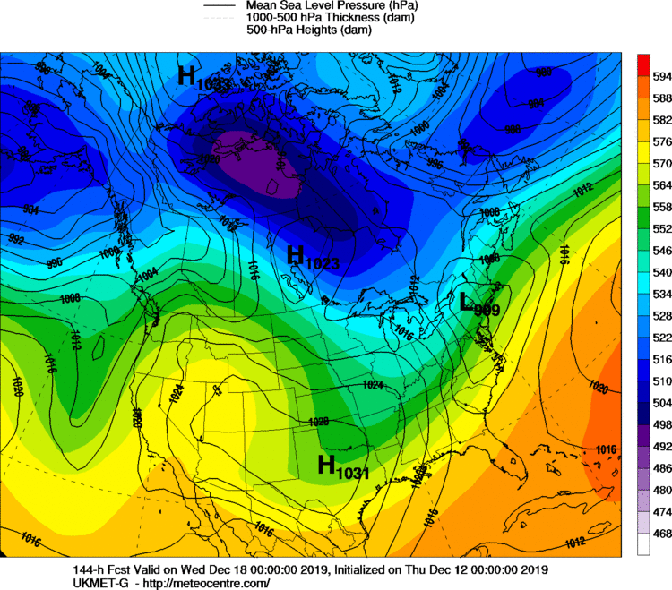
The vortmax might have even trended further west today. That's causing an issue with the qpf too. We're not getting that big WCB smashing into the cold high like we'd normally want to see on a big front ender....instead, its weak overrunning precip so we get these 1-3" type solutions changing to a bit of sleet and freezing rain. Sfc is frigid but the qpf just isn't there for a big event. Maybe we trend that vort a little better in the coming days.
-
We've had that on a lot of runs. That little weenie block in the Davis strait is probably helping stabilize the run to run variance. It's not quite the unmanned firehose.
-
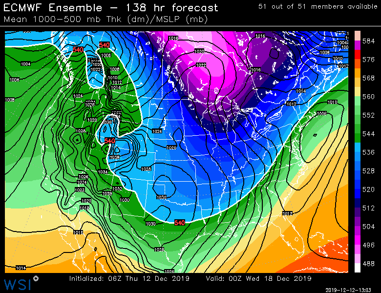
EPS seems like it's been like this for several runs in a row. Pretty consistent considering the lead time. This is the 06z run
-
Must've gone wild on front end qpf since the Uncle track isn't one you would expect for a foot of snow.
-
The dec 17 threat does have a SWFE vibe to it. Even on the euro the vort track is pretty classic. It's just a little more sheared.
-
Yeah it did very well in the dec 1-3 storm within about 9 hours.
-
I def love the snow at night during Christmas season
-
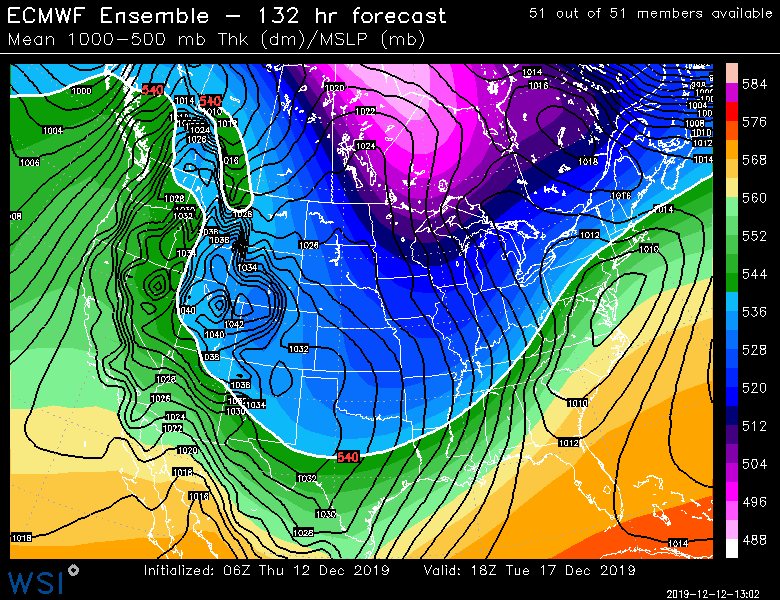
So far at 12z....GFS still western outlier with a lakes track though prob some CAD on that, 12z Ukie is fish food well suppressed, and 12z GGEM is a pretty wintry event with snow and prob some sleet in there too....hitting most of New England with something. Pending 12z euro . Still 6 days out so this is mostly fodder. But this threat has been on guidance for several days already pretty consistently.
-
Looks like 25.9 through end of December. (5.6" in Nov '95 and 20.3" Dec '95)
-
You can see how good the snow growth was in that pic. This storm had high ratios. Esp elevated terrain where they didn't lose much qpf on the front end of the changeover. Dendritic growth was excellent and that variable was actually portrayed very consistently on model guidance. One lesson this event should probably drive home is when there is really good snow growth progged, don't get too bearish/pessimistic. Cross hair structure makes up for many different types of sins on an event. If the lift had been progged to be maxing out near that layer of dry air, then it would have been different. But in this case, it was above the dry air in a saturated snow growth zone.
-
SNE got worse luck last year imho...at least in MA. Esp the pike to NH border zone....we were missing stuff by 30 miles. At least we were still comfortably above average for snow in '07-'08 in most of MA
-
It looks really good for next week albeit not a ton of wiggle room.
-
Around 5 inches on winter hill. Nice little jack in the ORH to Kevin zone.
-
GFS is def the western outlier by quite a bit next week. Hopefully we get something closer to the consensus...that would probably make many happy.


