

ORH_wxman
-
Posts
90,902 -
Joined
-
Last visited
Content Type
Profiles
Blogs
Forums
American Weather
Media Demo
Store
Gallery
Everything posted by ORH_wxman
-
Not just the euro. GFS went south about 1000 miles. Its not going to be remotely stable on this kind of a setup at 7 days out.
-
Would actually make sense with the pv love trying to dive in. Wonder if this trends more toward more stuff on the backend and less on the front? Euro has been pretty paltry on the front end the last few runs.
-
Yeah that would prob help produce some currier and Ives stuff on the back end.
-
Stubborn euro. That wasn't much of a move. Very slight tick.
-
It could easily be pretty wintry for Xmas too. You have the high heights in Davis straits over to Hudson Bay.
-
Ukie came south too but it was also in the GGEM camp last night.
-
GGEM came south quite a bit...which isn't surprising since it was the northern outlier....goal posts are narrowing,.
-
That's happened plenty of time....we all expect the Euro to trend like other guidance, it remains stubborn, and then other guidance caves. That said, the other guidance has already caved quite a bit to the Euro in the past 24-36 hours...so a tickle north on the Euro wouldn't be surprising.
-
A bit early to get specific....but some windex potential in there.
-
My guess is a pingfest in CT after an inch or two....maybe some meatier ZR down in interior SW CT.
-
Yeah I've been thinking everything will tick back north. The explosion of CNE/NNE posts at 12z have confirmed the trend without looking at guidance.
-
I'm not sure I've seen a model perform, that bad inside of 36 hours. Maybe the GFS in the 2/10/10 storm....
-
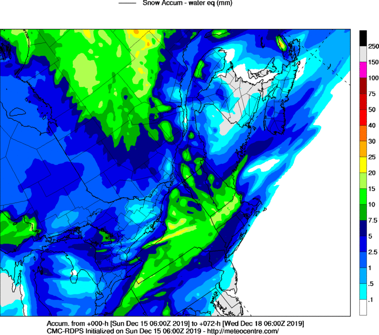
RGEM def has its own ptype algorithm unlike, say, the Euro. It's why it's one of the few TT maps that doesn't say "includes sleet" in the snowfall. So I'm pretty sure meteocentre just rips the liquid straight from the RGEM ptype parameter.
-
Yeah I'm a little skeptical. Prob be some minor glaze in spots...but this is frigid below 850-900mb so my guess is the non-snow ptype in the interior will be mostly sleet. There may be a thin band of solid icing just inland from the south coast of C/SW CT where the midlevels really intrude deeper but sfc stays below freezing?
-
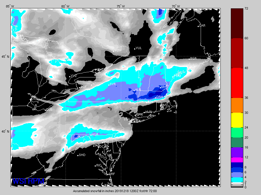
RPM not as suppressed at late yesterday. 12z loves Pike to S NH....really sharp cutoff with almost nothing in CT/RI
-
06z
-
00z run.
-
It's been leading the charge though...yesterday it was on its own for keeping the N of pike to S NH crowd all snow...now pretty much all guidance at least shows that. I do expect the trend to halt at some point here though and prob tickle back N a little. The question is whether we get another round of colder/south solutions before that reversal happens.
-
Yeah if that map verified, hubbdave would be around 60". ORH would be well into the 50-55" range. Always fun to dream. Long ways to go on next weekend's threat though. At least we've got it being picked up across multiple sources of guidance.
-
Yeah that's not happening. Lol. 06z euro qpf is too far south based on ML look. Actually that's probably true on most model runs in these setups. Focus the qpf closer to the low level front and then ignore where that nice 600-700 stuff is going on and you get a stripe of 6-7" and everyone starts going "models busted!!"....well sort of. They busted on qpf but they were probably correct on the midlevel features.
-
Doesn't mean they are wrong. This could easily tickle back north. I kind of expect it to.
-
I'm surprised this keeps tickling south. At some point these usually start ticking back north a little but the NAO block seems to be doing some work...toggling more recent runs vs runs 24-30 hours ago, the heights in SE Canada are definitely lower on the more recent runs. The shortwave in the plains is also not as deep. A combo of both of these things.
-
NAM is always fun for some laughs. I think it was powderfreak who once said that nobody would really pay attention to it if it came out at 1 instead of 930...lol. I was spewing a little hyperbole there...some pingers actually prob make it past the pike that run but not by much. Amazing how it changed like 100 miles in one run.
-
So the NAM went from pinging chickens and congrats powderfreak to Montreal on the 18z run to all snow for the pike region on 00z....good model.
-
We need mainejayhawk to create a gif of you jumping out of an elevated deer stand.


