ORH_wxman
-
Posts
90,902 -
Joined
-
Last visited
Content Type
Profiles
Blogs
Forums
American Weather
Media Demo
Store
Gallery
Everything posted by ORH_wxman
-
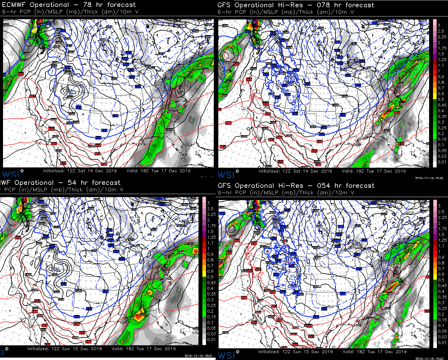
I didn't have time to go back and do every run....but here's Saturday 12z and then Sunday 12z.....Euro yesterday was pretty putrid...even when taking into account the QPF is misleading...Kevin is right that some of the runs showed lift further north, but it didn't get anywhere near powderfreak or even central VT/NH on that euro run. It definitely lost yesterday in a shorter time range. GFS lost Saturday....that's way too amped.
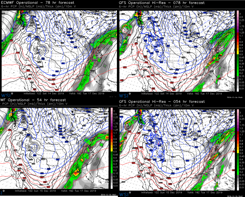
-
GFS was way overamped for several runs. I think a lot of this is influenced by perspective of those on the edge of the precip. If there was a 30/70 or 40/60 compromise in favor of the Euro, it will look like the GFS "wins" for those who were out of the main precip....when in fact it was so amped it was sending sleet pellets knocking on the chicken coop's front door and giving literally no snow south of the pike. I haven't actually gone back and looked at, say, the 6 model runs from 48-72 hours out to see exactly which one "won" the compromise....but usually when I do those things, I see the GFS losing the battle. Maybe it's a stability thing, not sure. I definitely don't think this has been the Euro's best storm....it really did well in Dec 1-3.
-
They could probably get away with a warning north of the pike....they will prob have a decent number of 6"+ totals and I think the timing helps out any tiebreakers in case it slightly underperforms in the 4-5" range....gonna be worst right during early morning commute.
-
I highly doubt any ZR makes into ORH county....unless it's maybe a little freezing drizzle in the dryslot after most of the heavier precip is done.
-
That tight gradient N of pike is not real...it is an artifact of the clown map algorithm. You'll still see a general gradient from S to N.
-
For S RI maybe....I don't think 1" is a good lower bound in N RI. Looks more like 2-4/3-5 for N RI.
-
Need that storm to phase with northern stream to keep things cooler...or need the northern stream to dive in more even if it misses a phase. we have seen that at times on other runs.
-
That was a 6 hour snow map you
-
Yeah, the clown maps are left guessing more than usual on this type of setup. That map would leave you thinking that the sleet/snow line was nearly stationary between 12z and 18z just north of the pike when we know that is not the case at all.
-
If you get perfect conditions....say, very light freezing rain, or freezing drizzle with light wind and temps in the mid 20s....you can actually get a ratio over 1 since water expands when it freezes. It's rare, but in the paper I read a few years ago on these ratios, they did document some rare cases of 1.08 to 1 or 1.09 to 1 type stuff.
-
Here's an example....look at the 6 hourly snowfall between 12z and 18z....notice that really sharp gradient just N of the pike. The QPF doesnt look like that either...it's only the snow that does. Yet the snow line at 12z is still down in central CT/RI. So it is assuming that the changeover to sleet happens in the BOS-ORH corridor extremely fast after 12z and then halfts for 4-5 hours just north of them....which isn't very realistic. So you get these weird banded looks on the clown maps. It's a good example why not to rip and read them....esp if you are in a zone that transitions between snow and another ptype in between 6 hour panels.
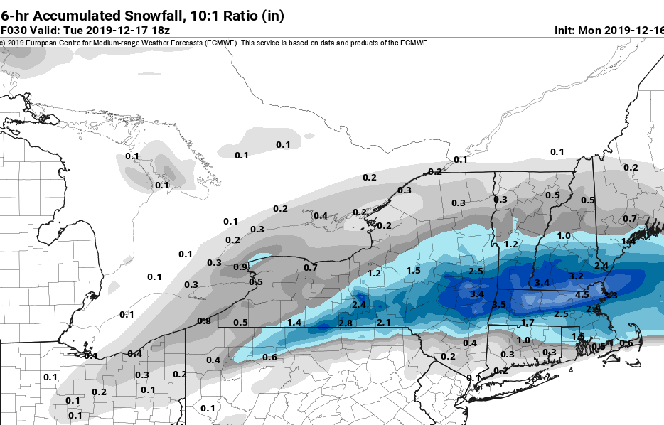
-
In reality, I think it would prob extend a bit further south than the clown map shows too because its cutting off the snow algorithm based on where the 18z snow line is which is just N of pike....most of the 12-18z precip is snow down to like BOS and even slightly south....but it starts to mix at 16z or something. But algorithm isn't hourly, so it doesn't know that.
-
Thump looks better than 06z down in SNE. Sleet will make it further north this run, but I like seeing the stronger dynamics.
-
Euro bumping north....ramping up front end QPF too.
-
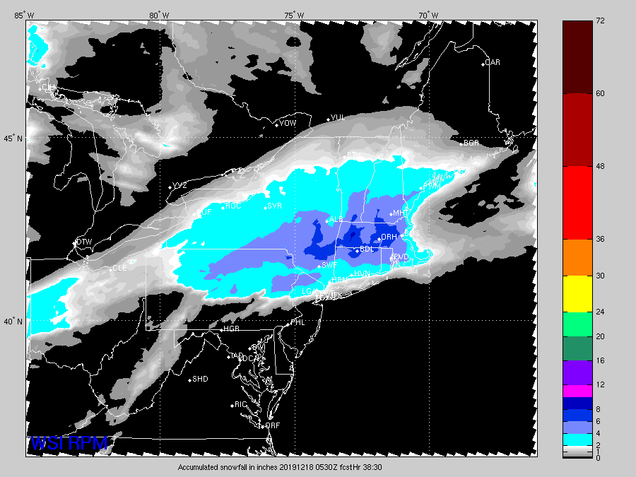
Yeah....RPM is also getting into the range where its actually useful. RPM along with the other shorter term guidance is starting to pick up on a pretty good thump further south too....for S CT. Prob gonna see advisory snows for most of SNE with a stripe of low end warning somewhere.
-
For Jerry...15z run
-
Yeah it's possible half an inch happens, I'm just pretty skeptical of it. Nothing wrong with using it as the upper bound though...upper bound should be where if most things go right. All these things to consider: - QPF could be overdone in general on some of these mesos - Lose some ZR QPF to sleet where algorithms are too quick to flip to ZR - Accretion efficiency? It can vary quite a bit depending on precip rate, temps, wind, etc...but median is about 0.70. As an aside, I actually always thought the ice storm warning criteria of half an inch of ice was kind of dumb and arbitrary anyway. Grid problems start ramping up quickly at around a third to 3/8 of an inch I've noticed.
-
Or you can do it with heavy rates....but it needs to be a deluge for hours....this is what happened in ORH county in the 2008 icestorm....we had like 2.5 inches of QPF that produced an inch and a quarter to an inch and a half of ice. But it took like 18 hours of pretty heavy rates to get there. Granted, we prob got to half an inch of ice the prior evening after 10 hours or so, but we were wasting a ton of QPF with that runoff.
-
I'd be surprised if anyone in CT saw a half inch of ice. There's definitely going to be some solid icing but you're prob not getting as much as the icing algorithms think. There's a pretty thick layer of below freezing air for a while....which tells me there's going to be some sleet in there that probably hangs on longer than ptype algorithms allow for...and then of course you have to lop off additional tenths because the accretion efficiency isn't going to have a 1 to 1 ratio (for every tenth of QPF that falls as ZR, prob like 0.06-0.07 will accrete, and that ratio falls during very heavy precip).....this is a heavy burst of precip that is prob done in 6-8 hours. Still, even a quarter to a third inch of ice is no slouch and could cause some issues. Can't totally rule it out though....a SWFE on 1/8/05 gave a narrow band in CT a half inch of ice. But everything has to go perfect when you're talking a duration that short. Most siggy icing events are much longer.
-
Yes but not as much as it has been. The guidance is converging now...the southern outliers like the 06z RGEM are getting picked off too.
-
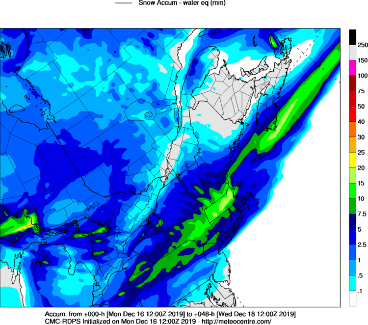
Here's the 12z RGEM meteocentre map for snow. Def a bit of a bump north on the max snows. That north of pike region though has been targeted on a lot of guidance...including previous RGEM runs that weren't as suppressed as 06z.
-
No huge changes on the 12z GFS from 06z....a very small tick colder/S it looks like.
-
12z was good there....the meteocentre maps haven't come out yet though. 12z prob gives you 6" or so.
-
The quebec sector did
-
Looks like Reggie won't be so suppressed like 06z was. Feel like we're starting to weed out the outliers now.