

ORH_wxman
-
Posts
90,902 -
Joined
-
Last visited
Content Type
Profiles
Blogs
Forums
American Weather
Media Demo
Store
Gallery
Everything posted by ORH_wxman
-
Prob pixie dust flakes forming the lower layer of cold below the warm layer. It's pretty cold at 900-925
-
Getting sleet and snow mixed in Holliston...but seems to be trying to transition over to snow as the steadier echoes move in. Looks about right based on dualpol....hopefully we can get a couple hours of steady snow.
-
Still gotta watch this evening in eastern areas. Could be some prolonged steady light snows.
-
You know it's bad when we start discussing windex in this thread.
-
Seems like even the northern guidance failed too because they were showing a way more organized system than this is. I mean, this thing looks horrendous. Orginally when this was bumping north the WCB started looking much better. Now guidance is having a hard time producing a quarter inch total in 6 hours here. Maybe this tries to get going this morning but it still looks pretty shredded and disorganized on radar.
-
I'm wondering how warm it even gets aloft....recent guidance is cooling things again. N of Pike might not even get a warm layer or if they do it might be weak and not last very long. The real strong warm nose gets pushed eastward more...which is also making the thump look even worse. But that is pretty classic for a sheared system that can't really wrap up a more consolidated WCB.
-
It's funny...in my head the whole time I was thinking "why is the thump looking so healthy when the shortwave look hasn't really improved?"...but I just kind of ignored that question and figured the models had this. Boy, was I wrong. My initial instinct on the really sheared shortwave look seemed to be the one to follow. It's not a more classic consolidated vortmax.
-
Man, just woke up and saw this storm and it looks putrid. Some of the guidance slides most of the best forcing offshore southeast of New England. What a disaster for the models on this one.
-
Even most of the main models started buying the initial thump down south earlier today. But it seems the guidance is now backing off on this initial surge entering E PA/NJ. They just fizzle it out. This was what was supposed to keep intensifying and give S CT the snow...but if it ends up weak then you get just a little bit of snow before the pingers and ZR down there.
-
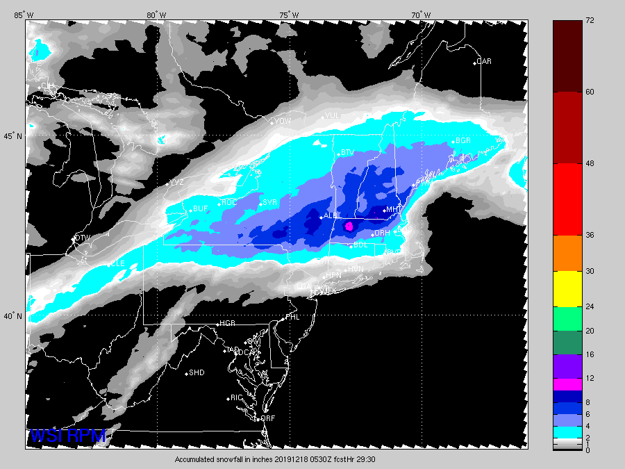
Here you go Jerry. Fresh off the presses 00z run. Really hitting the rt 2 to pickles corridor good.
-
S NH eventually pings. The key is how much of the big qpf falls by that point of course.
-
I see pinging around 18z at BOS. 850s stay cold but there's a Warm layer above that. It did cool from the previous though.
-
Little worried about the thump being less intense on some of these recent runs but there's been a lot of flip flopping on guidance so it's not worth pulling hair out over. I'm just going by experience with these...I think you'll prob still make 3" of sleet/snow even on the uglier scenarios so I feel ok going 3-5". There's a chance you rip 1-2" per hour for a brief time which could get you close to that 5 mark....and if not and you flip to sleet pretty quick...you'll prob pound out 1-2" of sleet anyway with maybe a little weenie currier and Ives to end it that may tack on a little bit.
-
3-5 for you including the weenie change back to snow tomorrow. 4-7 N of pike. That includes sleet too.
-
Euro looked a ticked colder/flatter but the thump looks weaker to me because of that. No massive changes though from a broader perspective.
-
Total weak sauce on the gfs thump.
-
NAM was pretty cold down in CT. Usually that's the model to check in SWFE if you're looking for big warm nose early on in the event. I would not be forecasting almost no snow down there.
-
Yeah you get a more widespread winter storm this way rather than a narrow area of advisory snows ad then nothing else. I prefer the thumps with their rates anyway....I'm also not one of those posters who is terrified of sleet pellets. I know some on here are, but to me it just puts more meat in the pack and we have bare ground right now, so we need some bass....no treble.
-
The irony is CT will end up with more snow than they would have on those weaker/suppressed solutions....this thump is way better than that trash on earlier runs.
-
It honestly doesn't look like a torch right now in terms of on-ground sensible wx...we lose the arctic air, but we have a sfc high rotting almost over us (or just west of us on EPS)....that is not a torch look. We can be like +2C at 850 in that setup and have a dry high temp of upper 30s to 40F with low dewpoints and low mixing. If we start getting a high off the carolinas with strong SW winds, then maybe we can reassess.
-
It's prob real....Euro has 3"+ down the south coast now in CT as well as most other guidance sans GFS.
-
Short term guidance caught onto this first it seems early today....and now the more "normal" models are starting to show it. Could be some surprised peeps in CT tomorrow AM if they don't recheck the forecast tonight.
-
I literally posted the Euro's worst run I think....that 54 hour map from yesterday. It was struggling to get even midlevel goodies north of Ray.
-
To be fair, the thermals are a really important part of the forecast....and the GFS looked pretty bad even in the midlevels in this one. If someone followed the GFS forecast verbatim and the Euro forecast verbatim in SNE, they would get burned way worse using the GFS because it showed almost zero snow south of the pike. This is really more about "northern extent of the precip shield"....which is only part of the model's verfication on a storm.
-
The argument was mainly synoptic evolution....not the thermals. The GFS thermals are absolute garbage as usual in these setups.


