ORH_wxman
-
Posts
90,902 -
Joined
-
Last visited
Content Type
Profiles
Blogs
Forums
American Weather
Media Demo
Store
Gallery
Everything posted by ORH_wxman
-
Lol. Obviously theres a gradient and it tapers off south. So yeah, there would prob be a few inches. But the best would be north. My gut still says it trends north again.
-
It's definitely less favorable the further south you go.
-
EPS looks pretty good for the pike region up into CNE/NNE. Definitely potential for 6 hours of heavy snow at the end wth that look. There's just not a lot of wiggle room down on the southern end of that range.
-
Honestly, I'd prob keep hopes to like 1-3" if you are south of, say, a Chris in Greenfield to Hubbdave to Ray line...if we get a trend better, then you'll be pleasantly surprised. But this still has all sorts of problems for siggy snow in SNE. It could even go wrong pretty easily for CNE too.
-
Yeah sort of..it had a much stronger secondary with a way better CCB than the 00z run, but it just redeveloped a bit further north, so in that sense the primary was a pain in the azz in hanging tough longer, but once it ceded to the secondary, it did so much more dynamically than 00z. Obviously if the redevelopment happens later than it doesn't really help southern areas.
-
That run would have hit Kevin's area hard and prob NE CT. I definitely want to see another tick south. We don't want that primary shortwave being too dominant. I have a feeling that it will be though...but even with that said, we could pick up an inch or two on the back end.
-
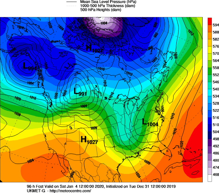
Jeez...GGEM is so far south it actually misses most of New England. A bit of light snow for SNE and nothing for NNE.
-
Yeah trended south. Still pretty hideous verbatim outside of powderfreak to Rangeley axis but hopefully a few more ticks.
-
He had warning criteria snow though. So it was semantically a legit snowstorm. Doesn't matter whether he was under a warning or not.
-
Yeah often you'd see NWS refer to radial ice numbers. Like even in the 2008 ice storm report from box they'll refer to the amounts of 0.50-0.75....that was definitely radial ice because flat was easily over an inch in many spots.
-
NAM would prob be pretty interesting for SNE too if it went out further. Def want to see another south bump on the 12z suite for snow chances.
-
ORH finished with 27.6" of snow...just 0.5" ahead 2007 for 7th place on the December list. Pretty good month. The two absolute raging cutters were a big bummer but can't complain overall. Spent most of the month with snow cover anyway.
-
This weekend is congrats powderfreak. We can maybe get a couple down here. I actually don't hate the 1/8 threat....I think op euro is too amped.
-
I'm pretty skeptical of this weekend. At least in terms of siggy snow. Need a lot of things to go right. But an inch or two seems doable. Hopefully those 00z runs were onto something.
-
OP Euro looks warm but the EPS and other guidance is actually offshore with that threat.
-
Yes....this doesn't give us anything frozen on the front end...just a rain in the 30s....but if we tick it a bit colder then it could start to get interesting. But yeah, you'd prob keep the sleet pack intact and then grab an inch or two of snow on top of that at the end in a solution like the 12z Euro.
-
That would actually be pretty bad timing on this run....that's around when it flips to snow at BOS. Obviously this could change quite a bit...it already has in the span of a couple runs.
-
Much stronger scooter streak shortwave out ahead of the main trough. It's flattening the flow and it causes the main energy to get shoved south more...so with that lagging energy at the base of the trough, it allows a flip to snow in addition to the more eastward track.
-
Pretty big changes on the 12z Euro for this weekend....we never warm sector...and it could get interesting on the back end. Out to 108, so we'll see what the next few panels bring.
-
Airmass is definitely garbage....no arguing that. But the further east it tracks, the more likely we can grab something on the tail end with the upper level energy....we want to keep the baroclinic zone south enough to make that a little bit more organized. The stronger cut scenarios rip the BZ up into canada, so it becomes hard to squeeze out anything on the back side.
-
It's a weird model....sometimes I see it, but then once in a while, it will be totally warm/zonked on a coastal too. I used to say the Ukie has "an extreme bias"....seemed to like to push the envelope of the other guidance ranges. But i do feel more recently, it's been a little more southeast. Esp this year. We'll see if that holds.
-
Yeah you might have a really strong correlation to the AMO decadal cycle perhaps? Which also seems to loosely follow the NAO decadal cycles. The '80s bottomed out and were frigid....you see it in the Greenland temps too where they were torching in the 1940s/early 1950s and then went into an ice box with really cold stuff in the 1970s and 1980s.
-
Lol...its barely a ULL...looks like it needs to eat a few cheeseburgers and fatten up. But I think most winter enthusiasts would take an inch or two if we could get it at the end so we didn't have to look at bare ground or patches. Interestingly, the Ukie doesn't even look like it warm sectors us...ever....can't see 108 hours which is annoying, but nothing about those two panels looks very warm
-
I wouldn't expect much of anything yet....but it wouldn't be shocking if there was like an inch or two at the end if that trend persists.
-
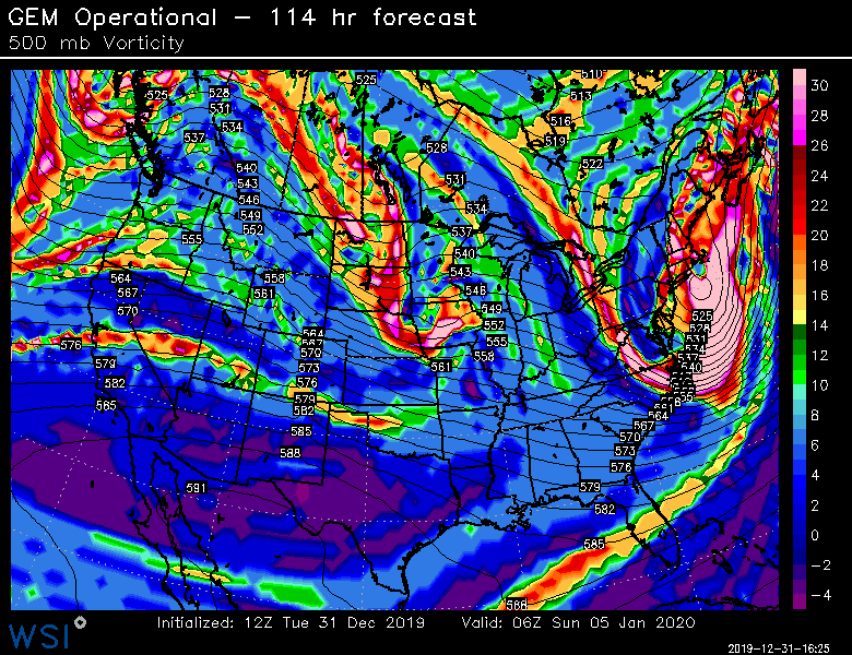
This is kind of what you want to look for....GGEM has some pretty good energy going underneath SNE which is why it tries to throw some light snow behind as it exits