

ORH_wxman
-
Posts
90,902 -
Joined
-
Last visited
Content Type
Profiles
Blogs
Forums
American Weather
Media Demo
Store
Gallery
Everything posted by ORH_wxman
-
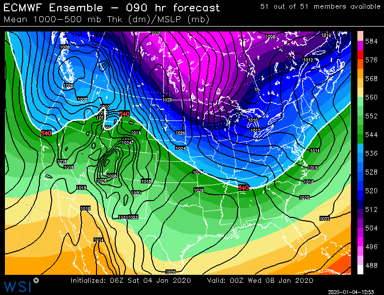
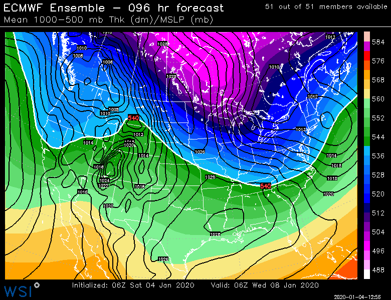
90 and 96
-
Out to 84 so far
-
That looks pretty nice. Too bad we didn't get one more panel on that run.
-
Euro tried to give a parting gift for E MA on tonight's run. Might have to watch that...nothing big but could be a quick inch or so if it pans out.
-
Looks like overnight guidance coninutes to shift in the east/progressive direction for 1/8....weaker system but colder. Prob snow for most of SNE off coastline.
-
ORH hills are definitely considered interior if you were unsure.
-
They get clipped with the late development....same part of the system that was forecasted to bomb out like crazy and give 6-10 by the Euro 36 hours ago.
-
No, it's not going to end up as a FROPA....it will be a real storm...just wouldn't surprise me if it tames and goes a bit east....which actually might help SNE to be honest.
-
Oh yeah...agreed....I was saying that the last two days when others were complaining that the rogue 6-10" solutions weren't going to work out....an inch or even flakes to me is better than a 55F cutter.
-
Even I...the ultimate snow lover....would have a hard time getting up for a 2-4" snowfall in early January if I lived in Bethel or somewhere else with similar snow climo. Too bad the more dynamic solutions have been lost....even some of the ones that gave SNE nothing at least were giving 8-10" up north in a wide swath.
-
Yeah the mechanics of this event are much more robust....but everything has trended more progressive/flatter from about D4-6 in this pattern. Starting with that 12/28 event. That was a 55F cutter to powderfreak 4 days out....same deal with this 1/4-5 event. Barring some other offsetting trend in the synoptics, I'll bet this one ends up more progressive too....it won't be enough to eliminate the storm though because it has a pretty nice looking shortwave...it will still be a good storm for a pretty good area, but it wouldn't surprise me if it tames a bit on total QPF and ends up more east than what it shows right now. That said, there could still be something to offset the progressive trend...maybe the upstream ridge becomes more amped out near the rockies and helps drive this deeper. I just wouldn't bet that way right now since it hasn't been happening in this pattern.
-
Yes, it's going to be a nice event for a chunk of the interior....we'll see how far southeast it can snow. Wouldn't surprise me if future runs tickle it a bit further E based on the reasoning above.
-
Euro is continuing with the theme of making 1/8 more progressive...makes sense based on the synoptic setup and fast flow.
-
It has your 30+ hour ice storm too at the end of the run......lol I'll preface this by saying this is a clown range map and not to be taken seriously
-
Yeah the euro was slicing it through BUF or CLE a few days ago. I never quite bought that though given the ensembles were well east and the pattern just doesn't seem to support wound-up westward solutions. This storm does get a little western ridge injection of energy late, so it tries to amp up....but it will be fighting against the progressive flow and the lead shortwave.
-
You'll like the clown range Euro on this idea....ensembles actually sort of support something like this too...might need to watch
-
This next one doesn't look like it has a lot of room to amp either....that front-running shortwave that gives the light snow showers on Monday is interfering.
-
06z EPS tickled a little colder for the mid-week threat...prob would be pretty nice for interior SNE up into CNE/NNE.
-
Assuming the low doesn't track almost over our heads....yeah maybe.
-
Sell.
-
This system is so disorganized...we really needed the good ULL given no antecedent airmass present. It will end up a disjointed ugly-looking system most likely with a zone of like 2-4" of wet snow for CNE/NNE. Maybe someone lucky gets a 5-6 spot. We could still see a bit at the end down here but it's not looking like more than an inch anywhere. The "storm" just shunts east really fast.
-
I'm selling the monster stemwinder solutions since this is still very fast flow. This storm could def bomb out but is going to be moving fast imho. So I'd favor the progressive solutions unless we trend the western ridge bigger....which could happen of course. But we've not been seeing that in this pattern.
-
Antecedent airmass is good with that. We don't even need phasing. A slightly flatter solution would be a big front ender. There's a few ways that one could snow. Euro verbatim wasn't that good though for SNE but it wasn't far off.
-
Anyone who got the goods in dec 1-3 is doing well this season. It was a big storm for a lot of folks. If you mostly whiffed on that storm, it's probably been pretty meh, but also not terrible.
-
I wasn't claiming they don't. Just that 00z didn't flip back which would have invalidated the 18z run. We got 3 consecutive runs with a pretty zonked upper air look. I never really bought it, but we did get an "on-hour" cycle showing it.


