ORH_wxman
-
Posts
90,902 -
Joined
-
Last visited
Content Type
Profiles
Blogs
Forums
American Weather
Media Demo
Store
Gallery
Everything posted by ORH_wxman
-
That shitstreak is gonna kill us....this is a better run, but that shortwave to the north is just a total buzzkill preventing this from being a much bigger event.
-
NAM is definitely NW....H5 looks a good amount better to me through 21h
-
00z rpm looks a bit NW again through 24
-
Maybe. But that SE ridge is a monster and we have a pretty deep trough out west. It's going to be a battle but not guaranteed we end up cold for the storm. Hopefully for the ski areas we get that southward trend that has happened in all of these at the day 4-6 range. That would keep them mostly snow.
-
Have you accurately overlayed the model forecasts on the satellite while also determining where the vortmax is?
-
Didn't you punt this 2 days ago?
-
I think it was even a bit later than that. I remember him most of that winter. RIP
-
I remember temps in the 60s in SE CT during the waning stages of the December 2008 ice storm. We were 30F and freezing drizzle with the entire grid down while SE CT was gusting to like 50 knots out of the S or SSE? I just remember seeing temps breaching 60 and thinking "holy sh**, what a temp gradient"
-
-
Honestly I wasn't even looking at the sfc when I made that post. Was just toggling h5. Sfc looks healthier though even if it didn't tick as much as h5 did.
-
Back that CCB up another 50-75 miles and then there'll be some fireworks
-
Euro is prob 1-3" SE of a BOS-IJD line.
-
18z Euro ticking NW too.
-
Yeah that happens a lot...that's why we need a big bump NW at 00z. Although every once in a while we avoid the messenger shuffle.
-
Here comes the RPM again.
-
Another excruciatingly small tick NW on the GFS....but again, get a couple more of those and it's advisory snows for SE MA and RI anyway....maybe far S CT too.
-
18z Reggie ticked NW too....but man, these are excruciating moves. For far SE places like PYM/Cape and S RI....a couple more of these small ticks would actually get it done for perhaps advisory snows. For the rest of us, we'll need something more substantial...and SE MA will need it too if they want something closer to warning snows.
-
3k really close to hitting the Cape and adjacent SE MA hard with the intense CCB....no dice verbatim though. Just some light snow with like 1-2 inches.
-
If that was like 100 miles north, this would probably be a quick-hitting 4-8/6-10 system...it's a pretty nice shortwave.
-
NAM is def better than 12z...but keep in mindthe 12z NAM might have been the worst run of any of the 12z models...it didn't even get the Cape (talking 12km, not the 3km)
-
18z RPM is going to come NW again...we'll see if this can at least be an advisory event for SE areas.
-
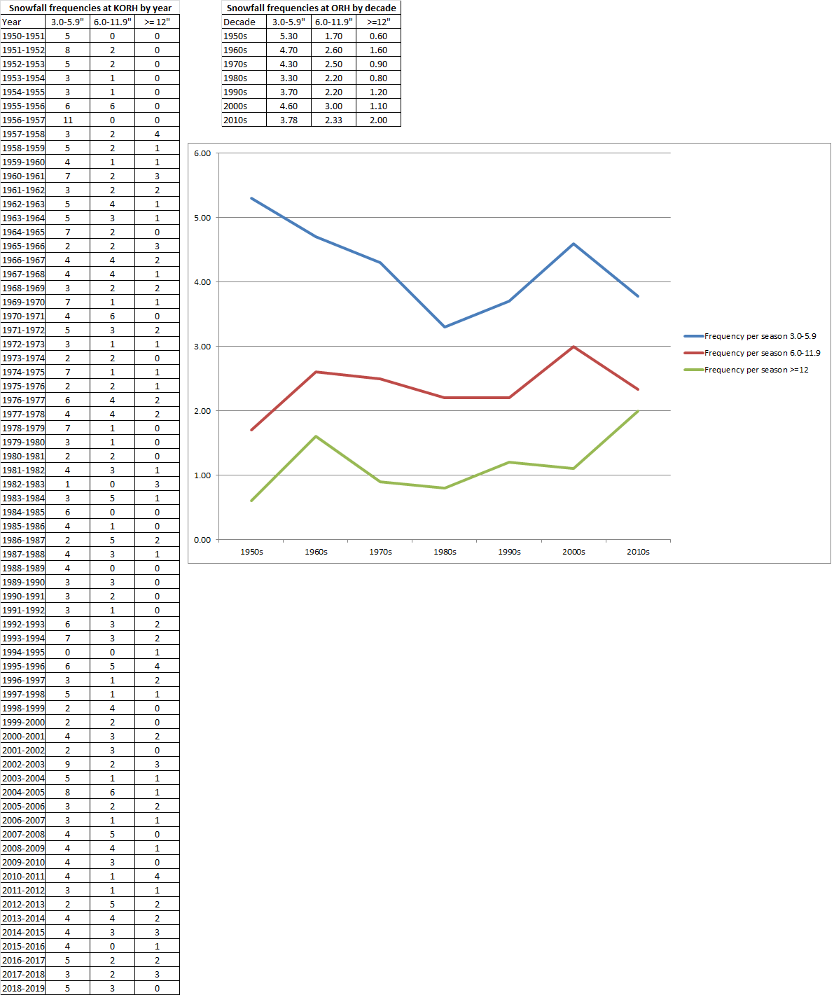
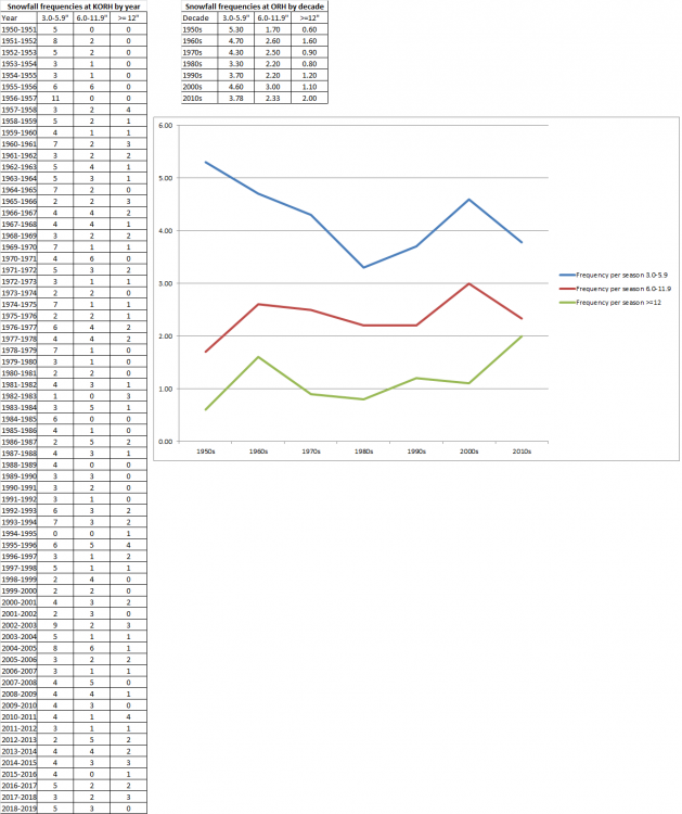
I did this for ORH last year....I have not yet done it for BOS, but I probably will at some point.
-
Bigger problem is the shortwave north of us....it just doesn't allow downstream ridging to feedback on this system.
-
Winter 2020 New England Banter and General Obs
ORH_wxman replied to CapturedNature's topic in New England
We have a Great Horned owl that lives near us...seen it a few times per year the past 2 years. We can hear it pretty frequently too at night. -
Yeah we really need more moves than this and the GFS is trying to shoot east at the last second too like the RGEM did despite looking better early on. There's still some time especially for southeast areas but it's quickly running out. 00z tonight is basically the Alamo last stand.