ORH_wxman
-
Posts
90,902 -
Joined
-
Last visited
Content Type
Profiles
Blogs
Forums
American Weather
Media Demo
Store
Gallery
Everything posted by ORH_wxman
-
06z GFS is almost a straight Miller B for weekend. Redeveloping low pretty early.
-
Pretty nice trend on euro for the weekend. Trying to redevelop the low more to our south. It's taking other model guidance to the woodshed for Thursday too it appears. I was a bit skeptical as it's generally compromised a bit when it's on an island but it doesn't appear that way this time. Thursday is toast in SNE but NNE could get a nice little advisory type event to get the ball rolling again. Maybe low end warning in spots.
-
GFS is def a nice front ender for SNE and all snow for NNE. Pretty good storm for spreading the wealth.
-
Thursday isn't gonna do it in SNE. Maybe some in interior elevated MA. But that system looks like CNE/NNE if it produces anything. A lot of guidance was sheared but Euro is winning the battle it looks like right now. Most guidance tonight trending toward it.
-
Oh nice. That's kind of similar to the collaboration site there but that ones only goes to 48. Thanks.
-
Where do you see rgem to 84? (Unless you are getting it in house) Used to be able to get it on uqam but now it seems it only works to 72 with the exception of the total qpf maps which still go to 84.
-
Yes. Got plenty of juice but it's hard to get more than a foot in those. Maybe some enhanced areas get 15ish. It could trend more redeveloper obviously. Then we could be talking about bigger totals.
-
I'm still selling those ridiculous totals unless it morphs into a more legit Miller B coastal.
-
Sell the qpf shown. It's likely overdone. It's a good threat though even if we take 50-60% of the qpf.
-
Yesterday and today actually reminded me a bit of the day before the 3/31-4/1, 1997 storm...just a bit windier than back then. Of course.... different pattern and time of year. We did get into the 60s about a week before the January 2005 blizzard. That month was Jekyll and Hyde.
-
I deleted the politics posts. Let's keep them out of here.
-
No I was agreeing with you. I thought the SV maps looked a little too feeble. I didn't word it very well though.
-
Looks to have some staying power. The first round looks not obscenely cold but when that PNA/EPO ridge rebuilds around 1/25 or so then we could see some more arctic shots. Think of the change occurring in like two phases. The initial phase is this weekend and early next week. Definitely colder and legit snow threats but the initial EPO block folding over and joining the PNA ridge is not the longer term change...that actually is only short lived and then reloads as a more coherent wave several days later. So that few day period in between could be more like seasonable temps.
-
It looked pretty feeble to me too in CT based on what I saw on the EPS for this weekend. But algorithm's....etc, etc.
-
I feel like it's a bit too amped but it could score the full coup. It's done it before.
-
You might have since yesterday could have been using most of that energy to warm up the interior of the snow pack. Once that pack gets sufficiently warmed, it releases pretty fast. But it can start slow if the interior pack is pretty cold.
-
Yeah I'm kind of hoping they pop 75 so that the monthly record is real. If they end up with 73 then it has a bigger asterisk than normal since the old record was 72F.
-
Yeah good call. I was a bit skeptical for your area but front seems to be lagging enough.
-
I'm selling the euro for Thursday. It is still an outlier. Admittedly stubborn though.
-
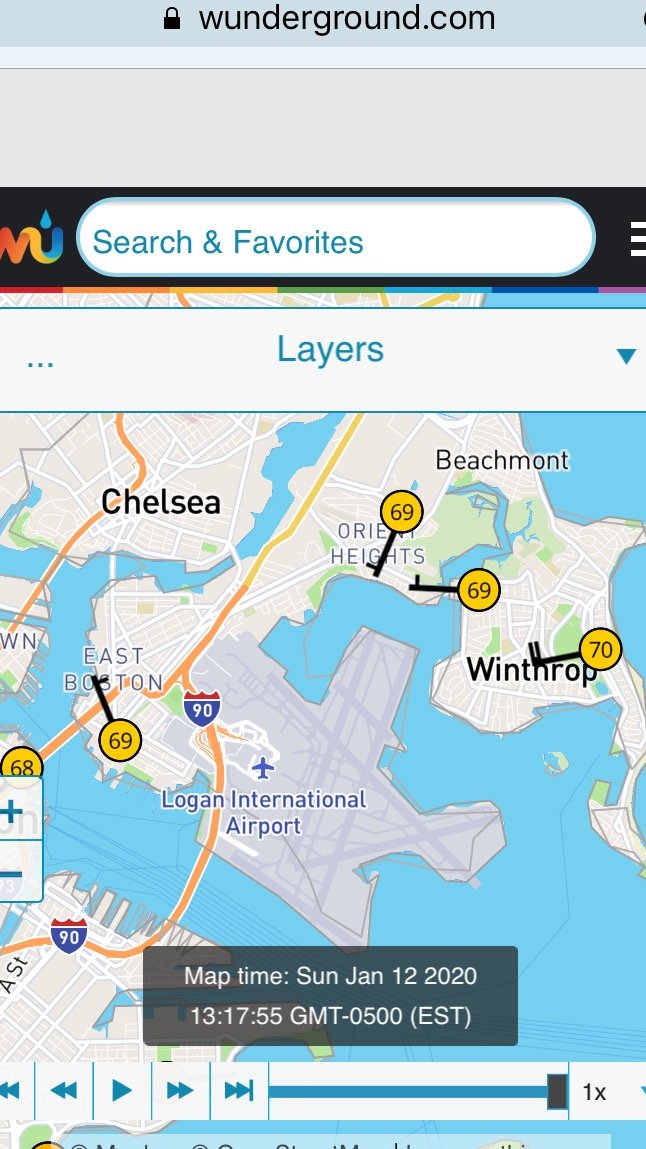
West side esp. More 69-70 near Logan which supports the 2-3F bias. We've been over this a bunch of times before anyway the empirical data is overwhelming...it's just a question of fixing the siting issue if it's not the ASOS itself.

-
See my explanation above. When we start tying or wanting records by a narrow margin, then it matters.
-
Ugh. They really gotta fix their siting issue and figure it out. First, it causes the warmest July on record last year when nobody else in SNE was even close...now it ties a monthly high (maybe surpasses it next hour). On any given day, 2-3F doesn't matter that much but today it will...difference between monthly record and not.
-
Yep. Fake news readings. Still a really impressive airmass.
-
I'd expect something a little less amped given how much of an outlier it is. It can still be "more correct" but you probably lose your big snow if it compromises even a little bit.
-
These are referring to 2015 for those who didn't get the reference. 1/24/15 was more of a thread-the-needle coastal than a SWFE...but it had some ptype issues over eastern and southeast areas for sure. So in that sense it could be similar sensible wx. I still have some hope that 1/18 this year will trend colder given the strength of that high. We just need to tone down the primary a bit on the euro.