

ORH_wxman
-
Posts
90,902 -
Joined
-
Last visited
Content Type
Profiles
Blogs
Forums
American Weather
Media Demo
Store
Gallery
Everything posted by ORH_wxman
-
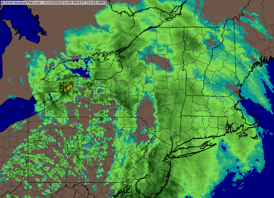
This sucker is racing....I'd expect maybe another 2-3 hours of snow here.
-
Someone else may be able to answer this better than me, but if the ASOS is not convinced that all the vis drop is solely from precip intensity but also from BLSN or fog, then it will report less then heavy. I'm not sure how it detects how much of the vis drop is from precip intensity though. I know it can sense falling precip obviously but it somehow distinguishes it from blowing snow too. In the case of BDR today, not sure why it didn't report heavy snow because winds were light and there's no actual fog.
-
Yeah I think everything is on track more or less. Most guidance didn't have more than an inch or two by 00z in western areas and very little at all in eastern areas. Models did cut back a little bit in SW CT today but they were kind of going wild there previously with more than half inch of qpf. Still looks like widespread advisory event for most posters with maybe some marginal warning amounts in the northwest interior areas and maybe a lolli or two further east where someone gets left with a couple transient bands maxing out. This is basically a 4-6 hour thump of light to moderate snow. Only briefly heavy in transient bands...with maybe 2 hours of lighter junk of each side of that period.
-
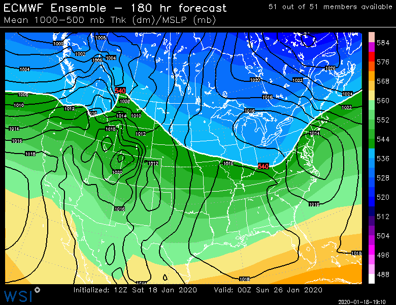
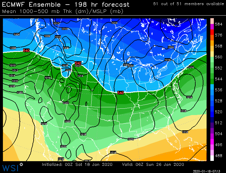
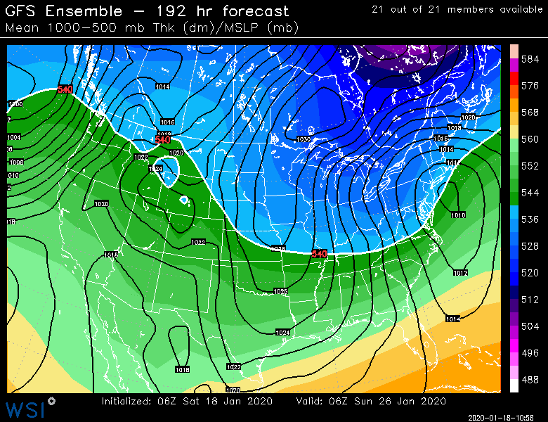
Yes. Only spot that is semi-decent is Canada with the higher heights in Hudson Bay and then at least the D9-15 range we have split flow out west which prevents a full-on 2001-2002 or 2011-2012 disaster.
-
Had weenie flakes for about 10 minutes and then it shut off. The real stuff looks about 45 min away from starting.
-
Pig gone wild this run of EPS. That is putrid. Only thing that kind of saves us is split flow out west.
-
HRRR is trying to advertise this as well.
-
18z rap loves the pike regionup into S NH/S VT for 6"+...not sure I'm buying that but the early start of the snow is a good sign. Not a ton of virga it seems like...surprisingly.
-
Yeah there's potential. But again...marginal airmass...here the Miller B look I was mentioning to the Pope earlier...I do like that high though.
-
We need Tip to give us a detailed description of the d7-8 euro where he hears birds chirping the day before the storm and the inside of the his car is warmed from the sun...then dark clouds move in and noodles start falling from the sky and the chimney smoke is now drifting southwest...and everything flips to heavy wet snow.
-
GFS actually has some snow next weekend now. The central Canada ridging is forcing some confluence and heights down to the east in Quebec which gives a decent high. None of this is really meaningful right now...but it shows what the ensembles were showing....if you get a decent high up there, then we can still score something with the storm approaching from the south.
-
Well with a better airmass we'd have more wiggle room on track. Say for example, we get the system tracking a bit west into PA and it's trying to develop off the Delmarva or jersey coast...a marginal airmass might cause problems in that scenario for SNE. But a colder airmass and that's all snow all the way. If the storm is already fully developed at the benchmark, then I agree it doesn't matter so much, but that is just the mean and it isn't showing all those miller B/redeveloping scenarios on storms that initially try to go a little further west.
-
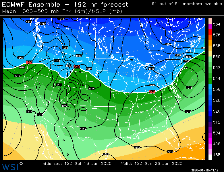
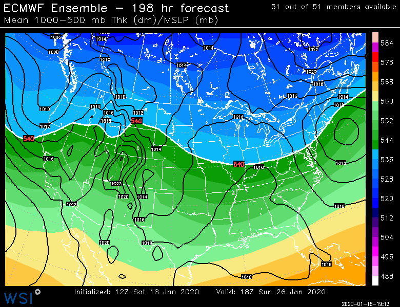
Here's the GEFS and EPS below. They are both pretty bullish on a system somewhere near us next weekend but you can see the marginal temps too. It could easily be rain on a more west track or even a whiff SE. I suspect the fate of this system will drastically change perceptions of the pattern regardless.
-
Lol being 11-15 days out is always a caveat. Everyone should know that. The newer guidance looks pretty unstable in that time frame so I wouldn't jump off the bridge over it. But I suspect many will if the D8-10 period doesn't produce a wintry storm.
-
Mitch is gonna get like 6" of upslope/IVT snow after the thump.
-
Yeah the speed of this thing is a real hinderance on upside. It's going to be flying through.
-
NAM ramped up a little bit everywhere it looks like. Even the scooter screwjie is shrinking each run.
-
GFS juiced up a little bit.
-
Those maps look pretty good to me. Might be a little juicy off to the northwest...though the orographic spots will get additional snows on Sunday.
-
People generally obsess over the warnings vs advisory thing when it doesn't matter that much on a marginal forecast like this one....the difference between 5.5" and 6.5" can be covered by a million different uncertainties: ratios, banding, model qpf error, low level enhancement, etc.
-
Wonder if Jimmy finally gets his OES on Sunday night behind the system with the IVT trying to turn the winds more N....might be more outer cape though.
-
It's possible...but this is like a 6 hour storm for the meaningful precip. I'm a little skeptical of QPF that high...though the Euro has been showing it. Euro did back off some on the 12z run, so we'll see if that continues tonight.
-
I could see Mitch's area there getting an additional 6" of upslope combined with the IVT hanging back....but for the rest of the non-orographic dwellers, they def won't be getting double digits unless they get super lucky in some fluff band.
-
It's improved mildly today, but I'm not sure a single model supports anything over about 7 inches for anyone in this forum....unless there are like 15 to 1 ratios or higher...which there could be, but it is hard to forecast for that.
-
EPS are decent. After our marginal storm threat next weekend, they are trying to return to the +PNA pattern....almost with some split flow out west too, so there would be southern streamers in the mix. We don't have the huge -EPO though, prob just mildly negatuve....but we don't need it if we can keep the +PNA look there. Jan and early February 2001 played out that way actually.


