

ORH_wxman
-
Posts
90,902 -
Joined
-
Last visited
Content Type
Profiles
Blogs
Forums
American Weather
Media Demo
Store
Gallery
Everything posted by ORH_wxman
-
Climo can pay us back in 100 years when we're all dead...
-
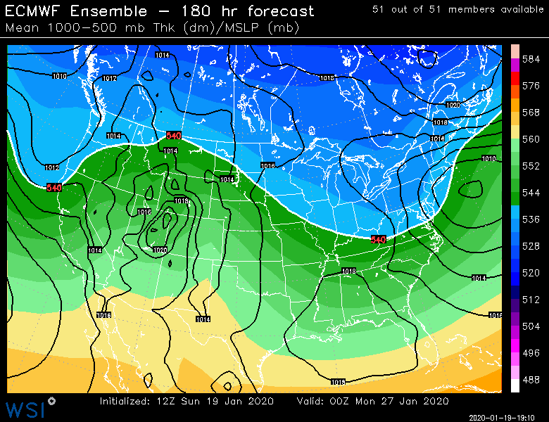
Yeah some. But keep in mind that was a system that looks like this on steroids. Some of the basics are similar. But if everything goes "right", this has a pretty high ceiling...esp interior.
-
Yep. All still possible. Could miss our whole forum still...but I'll say that last night and early this morning definitely increased the chances of a meaningful snowfall somewhere in New England.
-
Yes. 06z EPS would destroy the interior...esp east slopes.
-
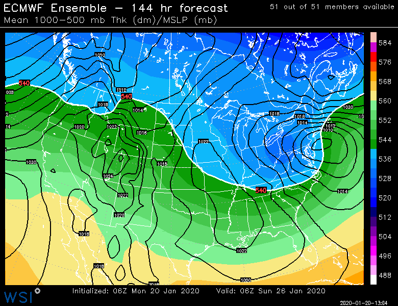
Fwiw, 06z EPS cooled a nice tick. Only goes out to 144 so can't see beyond that...
-
There is definitely potential. Obvious OP runs like the 06z GFS show it but you can see it in the EPS probability maps. Marginal airmass means interior and elevated areas are favored. Still, we've got some issues to overcome...mainly making sure the timing is good, but also the ULL track itself...a few of these runs are looping the ULL up a bit too far west initially before it spins east...we eventually flip to snow on those but the initial surge is rain because of the westward track...it doesn't tap into the "cold" to our north and instead draws in a bunch of Atlantic air from the ESE. So in short, keep a skeptical view of this system but definitely worth tracking because the ceiling on this one is pretty high.
-
Scooter electrical bath?
-
Esp at 6-7 days out. No reason to expect much unless this shows a lot of potential inside of 5 days...and really inside of 4 days.
-
18z GFS got the interior with 6"+...tick that just a shade colder with some better deepening and we've got something bigger. Obviously this is still not an easy storm to get to track "correctly". Need a lot of things to go right.
-
Yeah that's pretty crazy. A little December '92-esque though better climo period for coast. Though I'm always hesitant to throw that storm around. It had far more close contours at h5. But same type of high setup on somewhat marginal airmasses, the fact they are both cutoffs, and that deep layer easterly flow.
-
EPS are still showing potential. All we can say at this time range. Wish it was a little colder but the EPS are colder than the OP run and further north.
-
It's got potential still but you don't want to bury that ULL like that. Again...as Walt said...this is all about timing. You need that ULL lifting up to the northeast under us at the same time we're getting the good confluence. If you mistime them, then it's a boring solution.
-
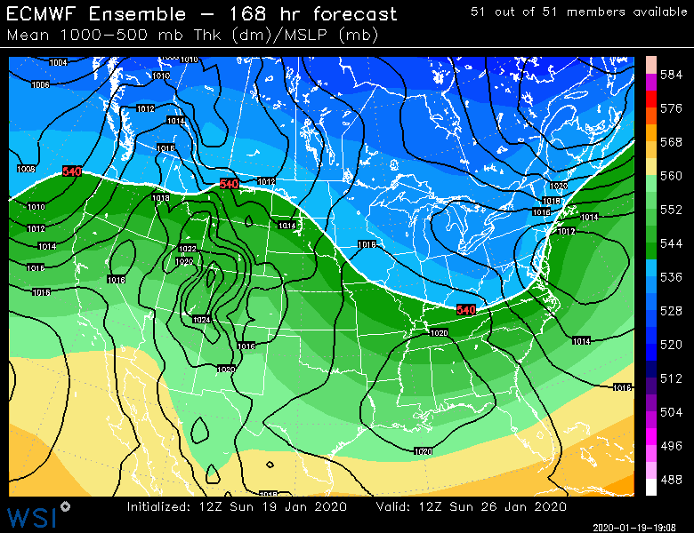
Euro doesn't look that good to me. It's ok. But it buried the ULL pretty hard and the confluence is not as good as GGEM.
-
If it happens, this storm will forever be known as "The GGEM Storm". Kind of like how 12/29/12 became "The RPM storm" Though in all honesty, GGEM solution does have some support. EPS are not far off. But GGEM seems to keep showing the perfect solution time after time despite the lead time.
-
Yeah starting to slow down the ULL a bit....we want it slower and a bit south of the GFS like the GGEM track...or some of the EPS. OP Euro was close too, but a a little too slow and digging for oil and it allows the best confluence to pass us by. Walt made a good point about timing....this is definitely all about timing the ULL approaching us in tandem with the best confluence in Quebec.
-
For those whole like winter, hope that split flow out west stays. Otherwise we're going full-2012. You can visualize how if we didn't have that split flow, those heights from Hawaii would be blasting the west coast and into the plains.
-
Yeah need a lot of stuff to go right. Interior elevated areas will be in most favored spot but gonna need the Synoptics to cooperate some and that's far from a lock.
-
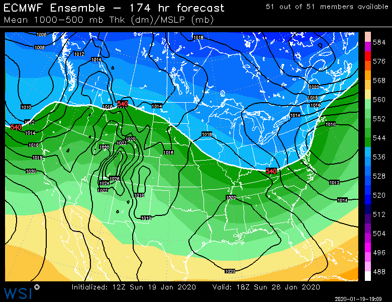
That doesn't look cold at all. GGEM is what you want. EPS are not bad but that Ukie look is actually pretty putrid...want heights in Quebec a couple notches lower.
-
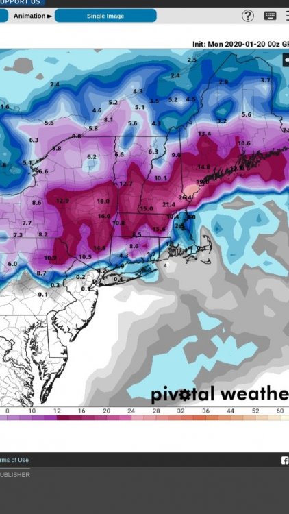
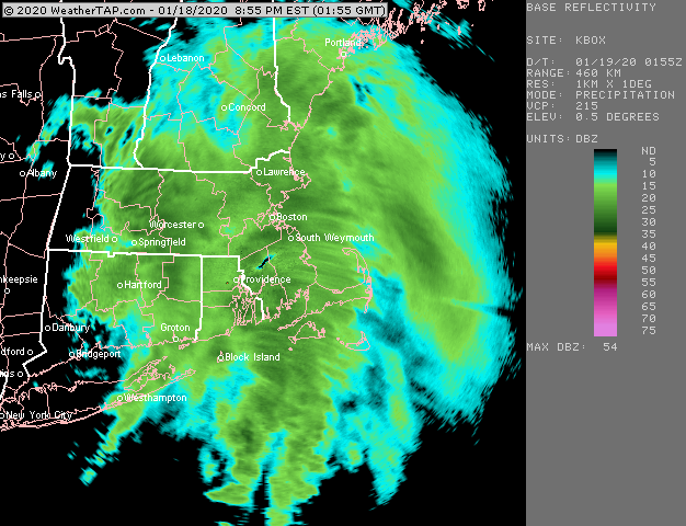
Just over 4 inches. Pretty satisfied with the event. Started slow but had a pretty nice finish. Still snowing lightly but looks like the meaningful stuff is done...maybe another couple tenths depending on what little batches try to redevelop in the next 30-60 min.
-
About 3.5ish eyeballing. Should pass 4 pretty easily. It's ripping with gorgeous dendrites the past hour or so. Prob have had over an inch in the past hour. First 3-4 hours were putrid sand. Really nice finale to the event.
-
Pretty good final hour
-
They did...next run is Monday. I suspect week 2 will look pretty crappy, but who knows. The EPS could change its tune too...they've been pretty swingy lately.
-
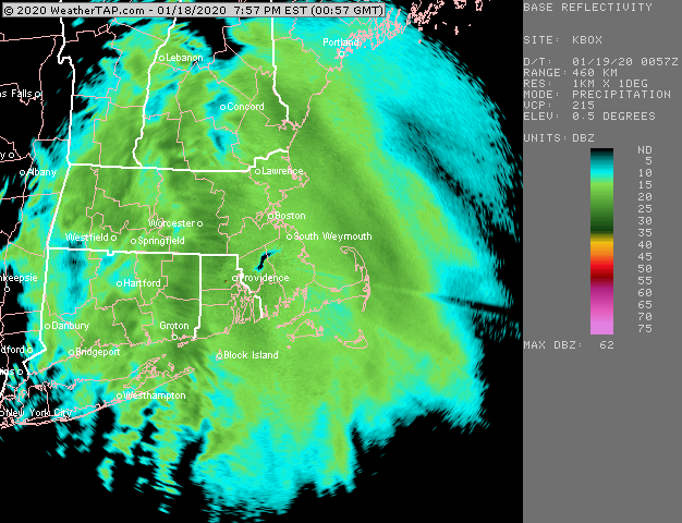
These bands definitely produce some good snow growth....way better than the first half of the storm which was almost exclusively baking powder junk. Too bad it's not gonna last more than another hour to 90 minutes or so...maybe 2 hours if lucky.
-
We're taking about different things. There's a chance for the storm next weekend to pan out. But it easily could be nothing. Kevin seems focus only on that storm. Then later on scooter and I were discussing the putrid EPS look after next weekend in the 11-15 day...that looks like dogshit but if you want to put lipstick on the pig you could say we have some ways that it could produce....split flow and some ridging up near Hudson Bay could make it tolerable versus an all-out disaster like '01-02 or '11-'12. We'll see though...it could keep trending worse too. But it definitely wasn't a good look in the 11-15. That's different than saying the day 8 system has a shot.
-
Getting much better snow growth in these bands that look a bit more convective looking. It was baking powder/dandruff before but now some actual dendrites mixed in.


