

ORH_wxman
-
Posts
90,902 -
Joined
-
Last visited
Content Type
Profiles
Blogs
Forums
American Weather
Media Demo
Store
Gallery
Everything posted by ORH_wxman
-
Nice firehose for SNE on the 00z Euro. That's actually a pasting near BOS too.
-
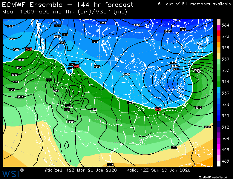
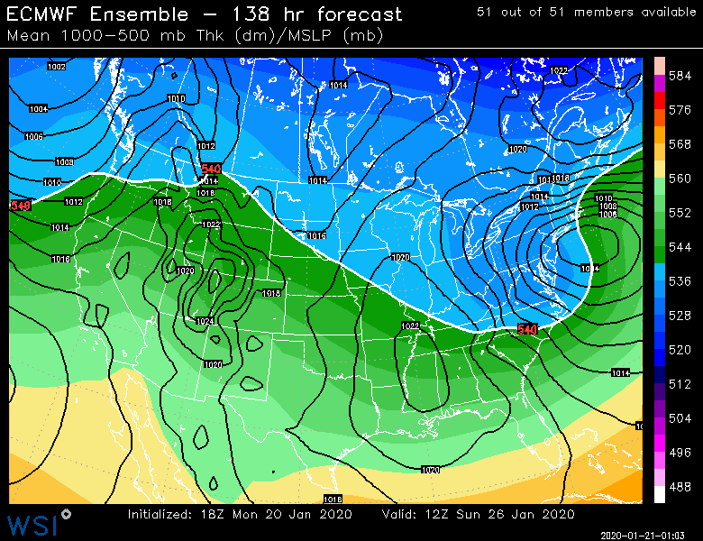
GEFS mean was already bringing the ULL in at a decently north trajectory and we didn't get any help. I agree it didn't change much from 18z mean, but we want that to trend toward the EPS. Ukie looked like crap though we don't get ensembles for it. OP Euro is actually looking pretty good track-wise here at 00z for interior SNE. Wish it was a little cooler but that's pretty irrelevant at this time frame.
-
Not all that impressed with the 00z suite so far. GFS was a good storm inland but it had a more progressive look to everything...which was probably a good thing on that run because the ULL initially was pretty far west at a higher latitude...almost sitting north of PIT. That's been the theme at 00z. ULL is too far north & west for my liking....still pending euro suite though.
-
This is a classic downslope look for the valley so I'd keep the skeptical glasses on for now...but things can change. Even a little bit of a difference in the flow or some PVA can spark midlevel stuff that could produce....but for now, I'd stay skeptical. I'm even staying skeptical in interior MA on east side of hills....I think I'd feel pretty good right now if I was in New Ipswich NH or something. But there's still quite a long ways to go that even they could get skunked. This thing could morph into some grotesque piece of garbage that tries to track into Poughkeepsie or something.
-
Well if you mean produce big precip then you're probably right. It's just probably rain there and not snow. It's precarious enough even in interior SNE.
-
Some areas did 7"+. But I think in central MA we did around 3-4" qpf. You really need a stall for things like that to happen. This one looks a little more progressive (which is saying a lot because this one is slow) but there's obviously plenty of time for it to change.
-
It was a horror show in the valley. Go east 20 miles into ORH hills or west 20 miles onto east slopes of Berks and it was anarchy.
-
EPS looked a little better to me than 12z. Below is the comparison (12z first and 18z second) You can see it in the high position
-
Basically what dec '92 did except a bit further south. Had the original sfc low tucked in over SE NJ but a secondary was spawning out southeast of the islands. With that high position though we prob know the interior will be a bit more backed than a model like the GFS says.
-
ORH obliterator. Might have to camp out on winter hill if that one verified.
-
In a few minutes, there will either be a lot of whining or too much excitement when the forum collectively weights the 18z GFS orders of magnitude more than its true importance.
-
I wasn't even on Eastern yet for that one. I did the blizzard of '05 on WWBB (Wright weather bulletin board for those who don't remember it)
-
Yep. Esp in this setup. Ensembles are going to be the way to go for now. You can't really worry about 1-2C in the column at these time leads. Or you can worry about them, but you scuslly have no idea how they are going to break. I'm mostly looking at the trend of that ULL track. We don't really want it getting north of philly when it's still out to the west over the Apps and OH/TN valley. Ray is doing the right thing in looking at the upper air there. In this scenario, ideal would be something like over the Delmarva or Philly at the most...any further north than that at that longitude is asking for trouble. It can gain some more latitude once further east and that is fine for SNE.
-
Wrong event. The one I was mentioning was 1/2-3/06.
-
Looks like El Niño. Jan '83 and Jan '98 come to mind. http://mp1.met.psu.edu/~fxg1/NARR/1998/us0129.php http://mp1.met.psu.edu/~fxg1/NARR/1983/us0123.php Though I do recall a blue blitz in early January 2006 and that wasn't a Niño...similar puke look though http://mp1.met.psu.edu/~fxg1/NARR/2006/us0103.php
-
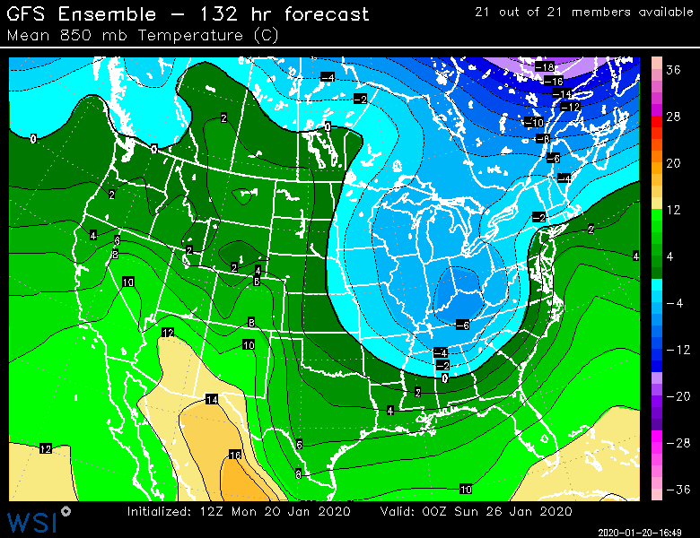
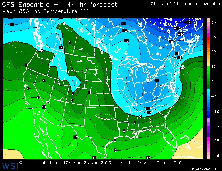
Shade warmer and west but still colder than OP. Not a huge trend but pretty much expected based on the OP run going west a bit.
-
That weird fujiwara interaction with the second shortwave early on really caused it to slingshot west...ULL ended up over PIT around 132h...we want that more like philly or the Delmarva. If we get that, then we'll see a significantly colder solution. That's what the 06z EPS did.
-
Dude, your odds in NYC are pretty brutal in this setup. You want to be inland.
-
Actually some marginal wet snow over interior that run despite that way west initial ULL. Won't take much correction to get that better....
-
ULL too far west this run. Didn't bury it as much as the 00z run though.
-
Midlevels looked ok on the mean. Not super cold but I'd guess at minimum interior SNE NW of 95 and prob N of. PVD-HFD like is in pretty good shape on that look...but it's probably gonna change a bunch of times
-
GEFS have been trending a bit colder too. They are still warmer than the EPS but definitely a tick colder than previous runs.
-
And hope the GGEM and Ukie are off their rocker in burying the ULL too much. If we trend towards that then its game over.
-
Yep. Classic setup for valley to get shadowed. Deep layer easterly flow.
-
GFS was excellent for a good chunk of SNE imho. Maybe southeast zones and right on the coast have issues but it was plenty cold for snow for many. GGEM is burying the ULL way south first. That is no good. If models trend toward that then we're pretty much cooked. It will be a 36F Rainer.


