ORH_wxman
-
Posts
90,892 -
Joined
-
Last visited
Content Type
Profiles
Blogs
Forums
American Weather
Media Demo
Store
Gallery
Everything posted by ORH_wxman
-
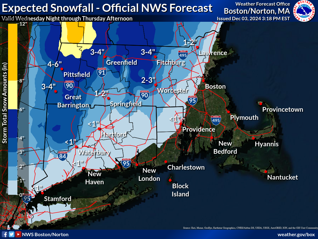
Should start seeing flakes in western CT soon. Looks like radar starting to blossom a little bit.
-
December 2024 - Best look to an early December pattern in many a year!
ORH_wxman replied to FXWX's topic in New England
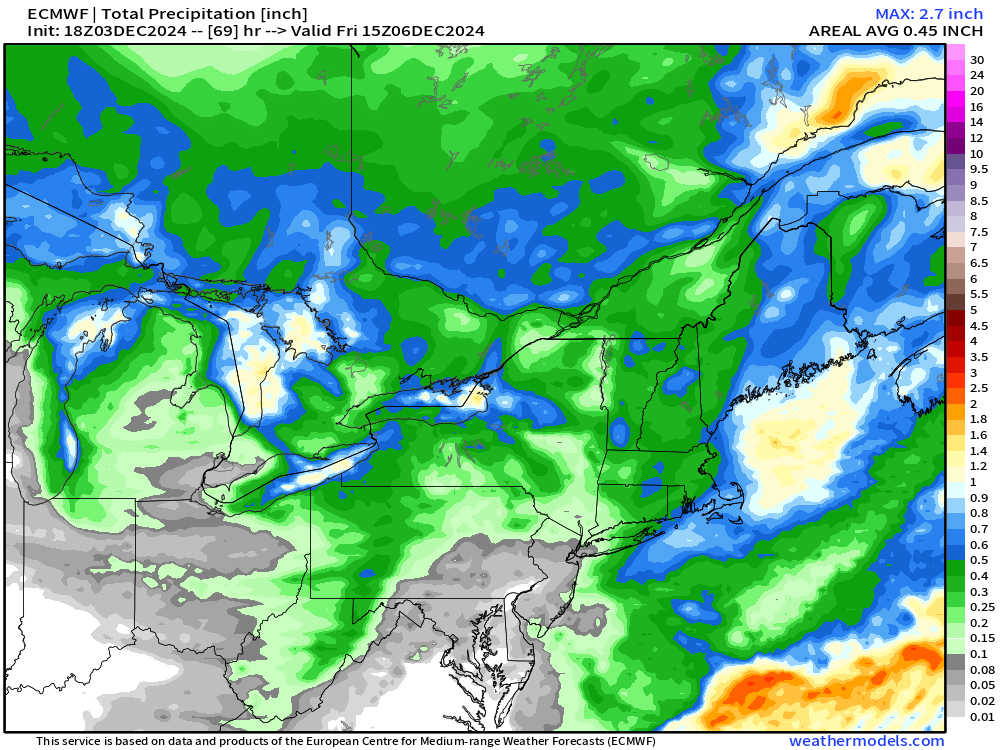
Two different scenarios offer a chance at something more wintry next week but we’re def going to be warmer at least for a few days prior to that. The magnitude is still in doubt. It could be 55-60 and rain but there’s a chance it never gets close to that warm either. I’d think it might benefit to torch for a day or two if we can press the boundary down behind it sort of like the Euro had. I’d say we wait and see what guidance does over the next 2-3 days on that front. -
RAP and HRRR continue to cool for eastern areas overnight. Pretty good burst of moderate snow for several hours right into Boston on both models. Prob not much accumulation right in city but just outside could see some.
-
Western spine of ORH hills have a decent shot but they’ll only issue warning if 50% of a given area is high confidence for 6”+. I don’t think the area would be large enough. Could be a situation where a town like Barre MA or Oakham or even North Brookfield gets 6” and Paxton MA at higher elevation gets 4” because of the terrain and SW flow. I think there’s def going to be a terrain gradient in the QPF too.
-
18z NAM gone wild for ORH hills to Kevin.
-
I’m still a bit skeptical but 2”+ would be great. HRRR def colder and RAP has trended colder as well all day…it tries to bring accumulating snow to close-in metrowest Boston like near Jerry’s hood.
-
December 2024 - Best look to an early December pattern in many a year!
ORH_wxman replied to FXWX's topic in New England
Euro has a somewaht different evolution…let’s that first system just completely cut while dampening out the southern stream (almost a glorified FROPA) but then behind it is another chance and that’s where we actually get scraped by that coastal at D9. That would probably be a more favorable setup than trying to get that initial high to press down which looks like a much heavier lift. -
December 2024 - Best look to an early December pattern in many a year!
ORH_wxman replied to FXWX's topic in New England
Jesus Christ take it to the banter/panic thread guys. -
Looks like 12z euro improved a bit for the 495 belt too. Not expecting a lot of accumulation there but better chance to see an inch or two versus just a few flakes.
-
December 2024 - Best look to an early December pattern in many a year!
ORH_wxman replied to FXWX's topic in New England
GGEM was kind of close too…but the key for next week is to drive that boundary further south and the little clipper that passes to our north this weekend is a key player…on runs where it’s further south, it drags the boundary more southeast behind it and gives New England a chance. Most recent runs have had it pretty far north…but 12z today has been coming a bit further south with it. NAM was furthest south easily (but can’t see next week’s system on NAM obviously). -
Sfc temps are mostly fake…look at 925 to get a good idea. Some areas might even radiate a bit right after sundown before clouds get thick (esp further northeast)…but that won’t matter if 925 is like +1.
-
December 2024 - Best look to an early December pattern in many a year!
ORH_wxman replied to FXWX's topic in New England
On the plus side, GFS might try to give the Rose Bowl snow again in clown range. @CoastalWx is really excited about another snow anomaly there. -
December 2024 - Best look to an early December pattern in many a year!
ORH_wxman replied to FXWX's topic in New England
That would require getting some good variance…not in the cards these days. -
December 2024 - Best look to an early December pattern in many a year!
ORH_wxman replied to FXWX's topic in New England
That’s a really close call next week on GFS. If we can get that little clipper system this weekend further south, it will make next week’s threat more interesting. -
GFS is basically all snow from 495 outward. Not sure I buy it but we’ll see if short term guidance comes in cooler as we get closer this afternoon.
-
He might get 18”+ from all the upslope enhancement behind it.
-
Yeah I’m hoping being near 495 with several hundred feet might help at the end. I’ll still be surprised if I get more than an inch. Won’t be surprised if it’s less. Could actually be some pretty good squalls in the late morning to early afternoon too. It’s really unstable so while the focus is on the synoptic stuff, there’s a great thermal profile for big snow squalls.
-
Yeah our area isn’t getting much. We may get a coating to an inch if lucky at the end between about 4am-8am tomorrow morning.
-
Your area is tough because by the time you get to Tolland, the highest hills are more narrow in width, so it’s like these small slivers where you’d focus the higher accumulations. So unless you know that area really well, most people will just gloss over. Even for Union, I used to always have to talk to my guy there telling him to ignore maps where they’d stop the higher accumulations near ORH and that you could extend them further south to his area.
-
December 2024 - Best look to an early December pattern in many a year!
ORH_wxman replied to FXWX's topic in New England
Yeah there was a nice training of squalls right in that area. -
I don’t think they pulled BOX map into the ALB map. BOX is still too low for your area imho. They need to up your area to Union CT

-
-
18z euro juiced back up some. Looks solid for NE CT up through ORH hills.
-
Gonna be a big difference between even the highest elevations of towns like Barre and Warren versus eastern spine of ORH hills near Holden/Princeton. Anytime there’s a strong W and SW flow, that QPF gradient sets up. Wouldn’t surprise me if a place like winter hill got 2” and 10-15 miles west at similar (or even lower) elevation gets 4-6”.
-
December 2024 - Best look to an early December pattern in many a year!
ORH_wxman replied to FXWX's topic in New England
EPS does have a bit of a reload occurring at the end of the run which matches the weeklies from yesterday which showed a good pattern setting up the final 10-12 days of the month. Always nervous about the western trough becoming semi-permanent but the guidance doesn’t show that yet at least.