

ORH_wxman
-
Posts
90,902 -
Joined
-
Last visited
Content Type
Profiles
Blogs
Forums
American Weather
Media Demo
Store
Gallery
Everything posted by ORH_wxman
-
You’ll know by 330-4. Watch that band of showers arcing up through BDR now. Once that goes through your area, you should max out your winds within 20-30 min or so in the dryslot.
-
HPN just got 51 knots right behind that band of showers.
-
That band of showers almost at BDR now. We’ll see what they can muster in the next update or two for peak gusts.
-
The short term maps are def a little better but those euro ones are awful.
-
Theres a longer period of like 30-40 knot gusts but the peak stuff seems like it’s pretty brief with that dryslot/mixing zone.
-
Yeah if that keeps happening, we should see BDR come in with a big peak gust in the next 20-30 min as that band of showers passes them.
-
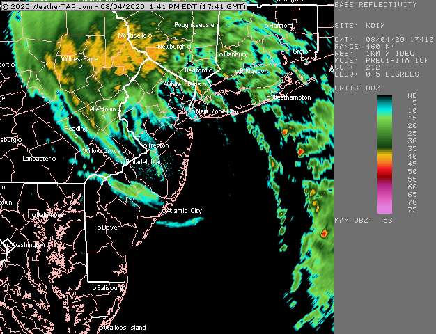
Right behind that thin band of showers again...that’s where the gusts are happening. For those who don’t know, FRG is basically just north of the “C” in “New York City” on that radar loop
-
Whoa at FRG
-
I never thought we were going to see many hurricane force gusts up here. Maybe a rogue one on an exposed bluff on the south coast but my bigger question was how well we’d see 50+ knots inland. Still not sure on that but the 60 knot gusts in NYC are a decent sign. It could still be mainly a south coast event though....interior is always tougher on southerly flow. At least there isn’t an inversion.
-
60 knots at LGA
-
That’s getting legit. First 60 knot gust I’ve seen. There’s a thin band of convective showers and it seems the little dry slot right behind it is where it is ripping.
-
There was a little thin band of convective showers that went through so it’s possible that is what mixed it down there in both places.
-
51 knots at MMU. That’s the first 50+ knot gust I’ve seen that far inland. They might have gotten a little sting jet barely east of the center.
-
52 Kts at LGA too
-
52 knots at JFK. 41 knots at ISP. Nothing too crazy yet but next hour or two is the peak there.
-
ACY got 57 knots...and they prob tickled 70 at 950 during peak. I’m curious to see what JFK and the further east LI stations get as they theoretically should mix better than ACY did.
-
I want to see what happens on LI pretty soon. That will give us a good barometer of what the south coastal communities may see.
-
I remember me and Phil got 60 knots with the handheld on the cape. Which prob means it was 65+ knots at 10 meters. Ill be surprised if there’s a lot of reports like that in this one but there may be a small window. I think the real test is going to be what JFK and those types of sites report in a couple hours. The LLJ is supposed to strengthen a little so we’ll see if we can do better than the 55ish knot stuff we’re seeing down in SE NJ.
-
ACY gusted to 54 knots. WWD also 54 knots.
-
Maybe the timing changed but we were seeing 55+ knots over RI/E MA at 00z tonight on previous runs with 65+ near the south coast.
-
53 knots at SBY 49 knots at WWD
-
Given the winds aloft, I’d think EF2 is possible for sure. Low topped supercells can produce but as you know it’s harder. But the wind and shear is there to tighten up one of these guys.
-
LLJ going across Delmarva right now so we’ll see what SBY to GEO reports in the next hour.
-
GON-WST def looks like a good spot later on.
-
Looks like the NAM shaved about 7-8 knots off the 950 winds down in SNE compared to 00z. Still looks pretty windy but I’m wondering how many 60+ reports happen away from the coast or really exposed areas. I think the TOR threat is a bigger deal.

