ORH_wxman
-
Posts
90,902 -
Joined
-
Last visited
Content Type
Profiles
Blogs
Forums
American Weather
Media Demo
Store
Gallery
Everything posted by ORH_wxman
-
Probably “first shot across the bow” airmass coming next week in at least NNE...SNE remains to be seen. The type of day where it’s like 70F and sunny and then all of the sudden when the sun disappears behind the hills/mountains, you lose like 15F really quickly and after another beer or two on the deck you look down at your hands getting pink from the chill. Next morning is like near 40F in the radiational cooling spots and you question leaving the window fan on all night.
-
It was the latter....I don't think we had any events that exceeded 8-10" in that month (maybe some rogue 12 inchers...esp CNE)...but we got hit by like 4 overrunning events plus a norlun that dumped 5-10" over a largish portion of E MA and SE NH/ME. The Kocin pattern comment was merely to observe that we sometimes obsess over the perfect setup only to be blindsided by a 40 inch month with a southeast ridge.
-
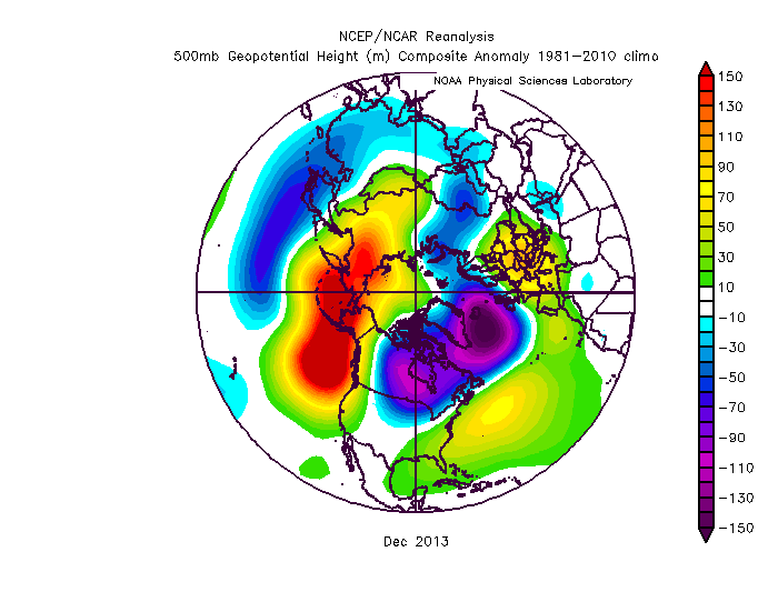
Even Dec 2013 wasn't exactly a Kocin Cookbook pattern, but we got walloped by a few storms that month
-
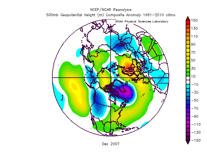
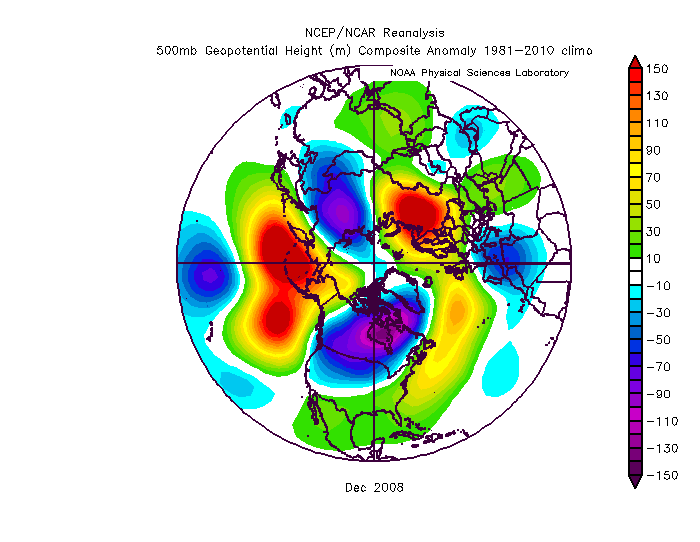
2008 was kind of similar too
-
Bummer, that puts all of New England out of the goods. There's always 2021-2022
-
Top 5 through 8/12 at all 4 sites....gonna lose ground though over the next week.
-
Lol, I was thinking the same thing.... Doesn't Kevin brag about wearing shorts when it's 45F? Now he needs to bundle up when its 59F.
-
I’d take the over at this point on 2035. We’ve basically had no trend in volume loss going back to 2010. You’d like to see something more discernible. Maybe there is another notable step-down currently in the works that will soon change the odds.
-
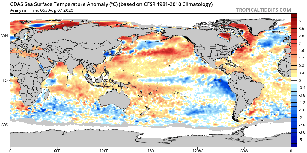
There's a lot of weak ice in the Beaufort/Chukchi region so I'd expect extent losses to accelerate again soon as a lot of that melts out and/or compacts, but we've lost any chance at a new record. I'm still expecting a top 3 lowest extent and area finish.
-
New England...where D0 and D1 conditions has everyone talking drought.
-
Euro seasonal is better than the others but in an absolute sense, it is still pretty inaccurate. It absolutely shit the bed last year even on the October and November versions IIRC. I also like to look at the H5 anomalies and not the 2m temp anomalies...they often don't seem in sync and the H5 anomaly forecast is going to be easier for the models to hit. IIRC, back in 2013-2014 and 2014-2015, it was showing these monster ridges over AK/EPO region (that largely verified) but they had warm anomalies in southern Canada and into most of the CONUS which is totally at odds with that pattern. So the H5anomaly was a lot more accurate for forecasting the sensible wx than the 2m temp anomaly.
-
Most of us hate high dewpoints in here. It’s a minority of posters led by DamageInTolland.
-
The Himalayas (below the snow level of course) during monsoon season are a good bet for the record. They get absolutely unreal precip for a few months of the year.
-
Summer 2020 Banter and random observations
ORH_wxman replied to Baroclinic Zone's topic in New England
I think you can be grandfathered in on that. There are several bars in ORH I used to go to that didn’t serve food. Like you could buy a bag of chips or something but they had zero actual meals or even hot snacks. -
I don’t think anything looks particularly bad. The N ATL cold pool is kind of annoying but it doesn’t drive the pattern...it can just act to reinforce a +NAO if it stays that way. Weak Nina is actually a pretty decent enso state. Most of the other stuff is pretty stochastic and not easy to forecast.
-
We’ve now fallen behind 2012 on both area and extent for losses. It didn’t take long to close the 800k extent gap. There is a good amount of weakened ice in the Beaufort/Chukchi sector, but I don’t see us finishing below 2012 on either metric.
-
Was it last year when we had that ridiculous airmass to the north in August? Could’ve been 2018...can’t remember exactly. But there was accumulating snow in Quebec with it. I think parts of Maine had a freeze.
-
The ice bath sitting there in the N ATL doesn’t inspire a ton of confidence for the NAO. Hopefully it doesn’t end up mattering. GOA has been cooling a lot too recently though still above average while the warm pool south of Aleutians has been strengthening....wonder if the PDO will try and go negative this winter.

-
Yeah it all depends on the relative location to the terrain around you. If you are on a local hill at 1500, it won’t radiate nearly as well as a local depression at 1500. Around there, you have such steep hills and mountains, that the differences get magnified. You prob radiate decent being generally between two large mountains but not as well as down the road along rt 2 in a relative depression.
-
Yeah the terrain is so steep in the whites there that you can have massive radiational cooling differences over small distances.
-
Summer 2020 Banter and random observations
ORH_wxman replied to Baroclinic Zone's topic in New England
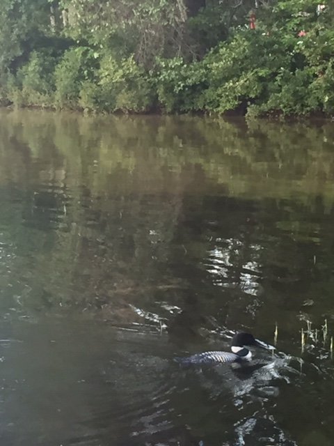
Loons out this evening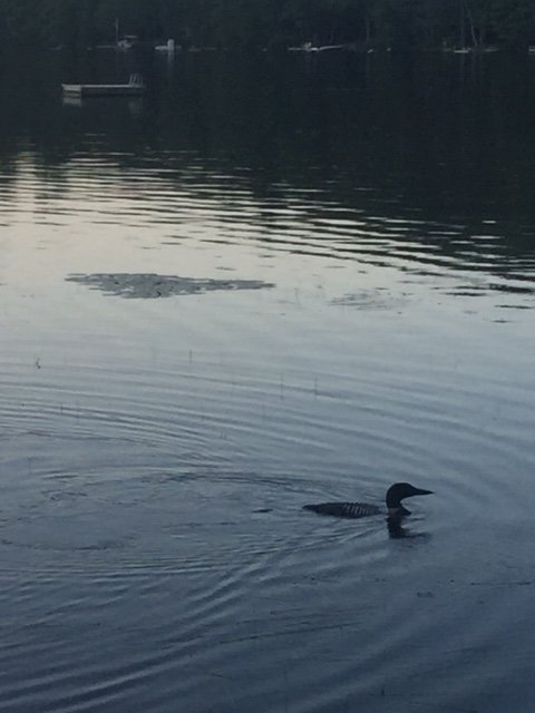
-
Summer 2020 Banter and random observations
ORH_wxman replied to Baroclinic Zone's topic in New England
Yeah the pandemic has driven a stake through a lot of zombies. -
Summer 2020 Banter and random observations
ORH_wxman replied to Baroclinic Zone's topic in New England
Yeah, shortys don’t exactly represent the same thing as long lived majors. -
Yeah 1804 hurricane-turned-blizzzard sounds about right.
-
Even a hurricane Bob like 100-150 miles west would be ridiculous.