

ORH_wxman
-
Posts
90,902 -
Joined
-
Last visited
Content Type
Profiles
Blogs
Forums
American Weather
Media Demo
Store
Gallery
Everything posted by ORH_wxman
-
The bolded....it's emotional forecasting.
-
It was mostly the early 1950s....at least over SNE....1955-1956 seemed to break the bad stretch.
-
Doesn't look like it's coming down very hard....high visibility. It appears the best lift is this evening though, so we'll see if they pick it up later today/tonight.
-
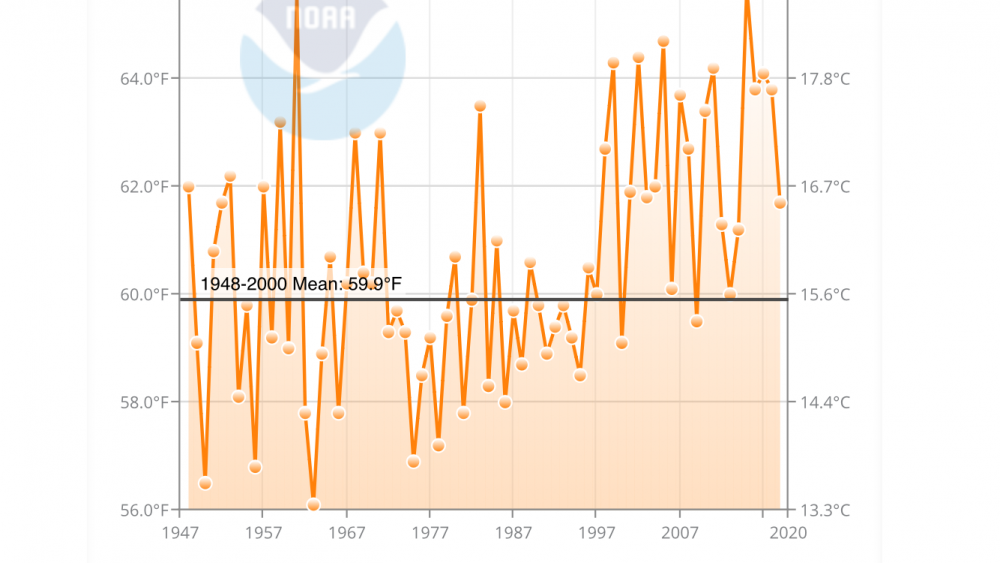
The 2010s are pretty unique for their warmth, though amazingly, the 1950s (not listed above) were the next warmest for ORH (at the current site)....they had an average October temp of 51.1F....the 1960s (also not listed above) were not far behind putting up an average of 50.9F...half a degree warmer than the 2000s. The 1940s may have challenged 2010s in some spots. ORH has an average temp of 52.6F for October in the 1940s....though 8 of those years were at the old site, which makes the direct comparison a little harder. The older site averaged 51.7F vs 51.15F at the airport site during the 15 overlap Octobers between 1948 and 1962. So even if you subtracted 5 or 6 tenths from those 8 years, you'd still have a warmer average than the 2010s. But we'll never know for sure. Logan airport did not match their 2010s warmth in the 1940s, however....but it was 2nd warmest at 55.6F.
-
Temps matter too...there are mid and upper 20s in WY where that snow was falling....you can easily get that to stick even if it's pretty light. It's different if you have 33-34F and SN- with a warm ground. 27F will make that very top sfc of the ground frozen pretty quickly.
-
Warm ground only matters when the precip is really light...... or after the snow stops falling, it can start melting from underneath. I've seen that when we get snow in November and it's only like 25F out the next day but there's still some melting from the bottom with upper layer soil temps still in the 40s. The surface of the ground itself will usually come in line with the ambient air temp pretty quickly, so immediate accumulations aren't too hard.
-
Very cold winter in New England as well but SNE missed the Feb 79 storm...whiffed to the south. They had some rainers in January where NNE got snow/sleet so the winter was largely a bust here.
-
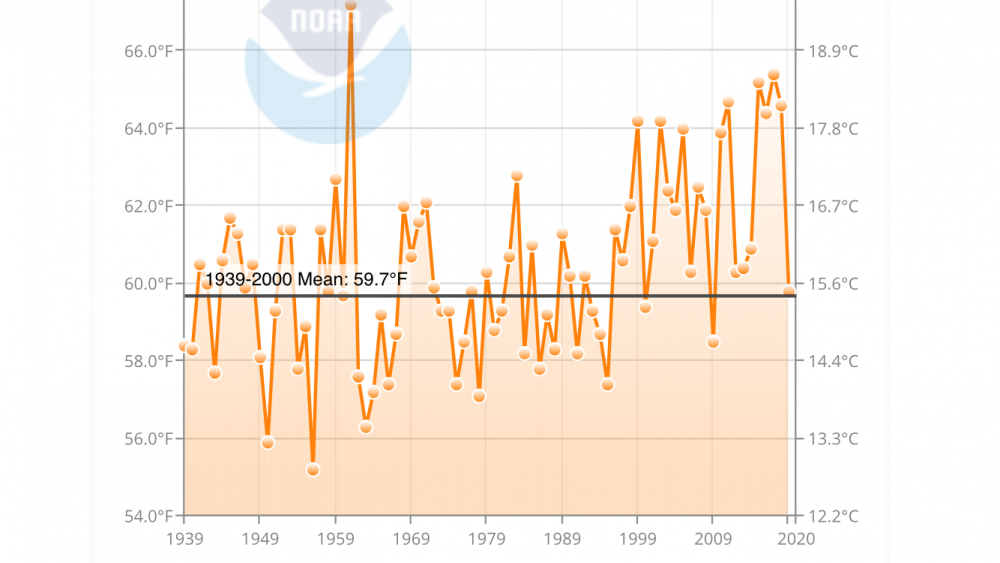
This is ORH. Definitely a little warmer in the past than CON but clearly still pulling teeth to go below avg in September these days. It’s actually amazing how consistently chilly the 1980s and first half 1990s were in September. Kind of fits my childhood memories at least CON is probably losing their ability to radiate too in addition to just straight AGW. Im not all that aware of how any developments or land use near the airport has gone over the past couple decades.
-
Pulling teeth to get below normal September at CON these days...
-
1930s were pretty terrible here too though there were a couple blockbusters mixed in (like ‘33-‘34). Some of our warmest winter months are in the 1930s. The early 1950s were horrific too.
-
You can include the first 3 winters of the 1990s in the bad period of the 1980s....and also 1978-1979/1979-1980. 78-79 was probably decent in NNE but it was utter trash in SNE. Rain/cold/whiff/rain/cold pattern. For ORH, there were 3 above average winters (1981-1982, 1983-1984, and 1986-1987) for snowfall and two near-average winters (1987-1988 and 1982-1983) in the 14 year period. But the clunkers were pretty bad. The freeze/thaw cycles were e bad in 1984-1985 and 1985-1986. Add onto that 4 consecutive garbage winters from 1988-89 through 1991-92 (you could argue 1989-90 wasn’t THAT bad), it’s not a fond set of memories.
-
The only White Thanksgivings I can think of for Buzzards Bay Area would be 1987 and 1989. It’s exceptionally difficult down there. Kind of weird that they had two so close together and probably nothing 20 years either side of that. There may have been snow OTG in 2002 not too far away but I think right down at buzzards bay they were too warm. But I’d have to double check that one. Edit: scratch 1987....just hit me that that one was Veterans Day. Not near Thanksgiving.
-
Not just now but it was rocking us in the October and November forecasts. It busted spectacularly. LR models aren’t very accurate...even the best ones. Just another example.
-
I went skiing up at Sunday River on March 21-23, 2014 and when we arrived at the old Evergreen Valley Inn (I made previous posts about this interesting relic) where we were staying that trip, there was about 42-45” on the ground. It was up to my hips/waist so I knew it was easily over 3 feet closing in on 4’. They had just gotten croaked by a 12-15” paster the day before so it looked even “deeper” than the actual depth as it often does with freshly fallen wetter snow. Very impressive. We got another 2” on the 22nd while there and then it just got frigid....that March was exceptional for the persistence of the cold.
-
We’ve had some very potent individual cold snaps in very recent winters despite the winters themselves not being that cold. Feb 2016 saw the coldest temps at BOS and ORH since January 1957...then the January 2019 cold snap saw the coldest high temp at ORH since 1994 (high of 1F)
-
Yeah we haven’t had a lot of that since the 2013-2014 to 2014-2015 winters....been a lot more zonal patterns since then, although 2017-2018 was pretty meridional at times...esp when we got that obscene late December arctic outbreak where we spent the better part of a week below 10F...though even that one wasn’t as deeply penetrating as some of those classic ones like from, say, early Feb 96 (circa weather channel reporting Tower MN got to -60F) or even back to back Dec 2009 and 2010 when we had deeply frozen orange crops into central FL.
-
Yeah over there it was an all timer for both snow and cold...some of the folks to your west had their coldest winter on record. Even Duluth MN which had records go back to the 1860s missed their coldest on record by like 0.2F or something ridiculous...the old record being like 1873-1874 or something like that I recall.
-
Looks more like a 2013-2014 pattern with the big -EPO/+PNA and raging +NAO. Not that there’s anything wrong with that really...very good winter.
-
I was thinking this....
-
Update as we get close to the minimums.... Current NSIDC area is 2.74 million sq km and current extent is 3.94 million sq km. These should decline a bit further to the min (prob sometime in a week to 10 days historically....perhaps slightly sooner for area). Pretty happy with the predictions so far....we'll see if there are any late season surprises.
-
We pay even more than that for 2 boys (4 years old and 1 year old)....it's ridiculous how expensive a high-quality daycare is. But our kids just started going back to daycare after a 6 month hiatus, so at least we saved up money, lol.
-
AMO is pretty staunchly positive on last update...at least on CPC. Most Ninas in the late 1960s/1970s had -PDO/-AMO. 2008-2009 and 2011-2012 did too, though the AMO was barely negative those years....doubt it had much of an influence.
-
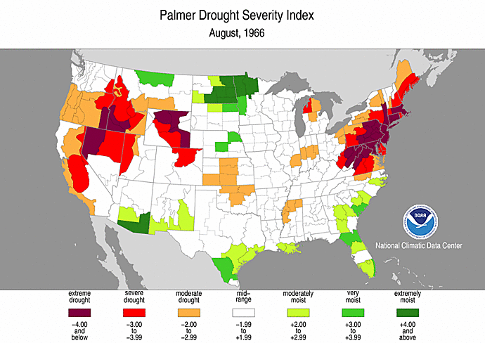
Wow, worst drought ever in SNE? It's as bad as it's ever been.
-
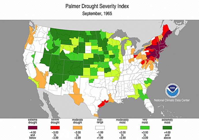
Not the exact same thing but it's a good proxy using the PDSI. It actually looks like the previous year September 1965 was worse
-
That would be an electrical bath for all of New England probably....lol. Though in reality, looking at that longwave ridge position out west, the whole thing would be shoved well southeast in the winter polar jet environment. That's an incredible airmass for early September in the plains though....they might get some snow into western Nebraska and not just the Rockies foothills.


