

ORH_wxman
-
Posts
90,902 -
Joined
-
Last visited
Content Type
Profiles
Blogs
Forums
American Weather
Media Demo
Store
Gallery
Everything posted by ORH_wxman
-
'04-'05 and last year took totally different paths too after December...last winter, December was extremely wet with near normal temps and then a blowtorch/dry rest of the winter....while '04-'05 was consistently pretty wet and not warm the whole winter.
-
Well he is on the Cape.....the place where there is actually a positive correlation.
-
Only issue i have with this is ENSO to precip correlation is basically zero over New England. Exception might be a weak positive correlation over far SE MA and south coast.
-
Lol that is like an old lady...wearing a shawl and preferring 90F over mid 70s like the other 90% of the population. At least Kevin has a Met now to root along with him in the summer for Atlanta climo.
-
Ha...I’m not choosing 88F humid over 73F coc anytime soon. Maybe if I’m vacationing on a beach for the entire week. But if we’re just outside hiking, throwing the ball around, riding bikes, etc, etc...give me 70s any day.
-
Yep. We had posters in GA too (Lookout and I think one or two others...Mr Bob I think was in GA at the time) I wish the old forum was still up like it was for years after migrating here...I had links to some of the big threads and it was always fun going back and reading them to see some of the handles that have long since disappeared. I remember a few years ago rereading some of the threads leading into 12/9/05 and there was a Tip post like 24 hours before the storm....he hadn’t realized that everyone left WWBB and then appeared just in time, lol....I was similar but made it a few days earlier. But the Tip post was hilarious as back then he was even more confusing to the casual wx weenie....he was posting something about the mathematics/thermodynamics of a potential tropofold event....LOL. It was based on some of the ETA runs going insane. Turned out to be a great call though in that storm.
-
That was Zonties in the feb 2006 storm, lol. But yeah he was also in SW CT. I think near Danbury.
-
We used to have a lot more SW CT posters years back but many of them either moved to one of the tri-State spinoffs or just don’t post much anymore. I still remember back when Kevin and I would pig pile on StephenCT in Waterbury for his “questionable” snowfall obs. Lol.
-
Yeah it’s def not all covid. He was throwing tantrums when we had a few 73F COC days in June....he’ll be wearing a shawl by next year when it’s 80F.
-
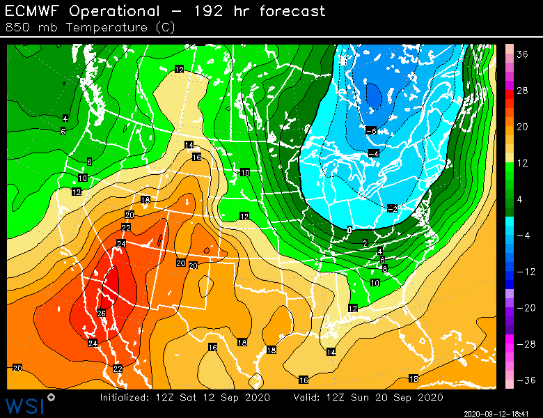
Ok this is pretty impressive for 9/20...still a ways out but it’s been showing up pretty consistently the last couple days.
-
Cold is important in SNE (less so up there) but precip is more important...unless you are on the south coast or cape or something like that. Most of our awful winters have low QPF (see last year after December)...there’s exceptions for sure but I’ll roll the dice with the active pattern any day.
-
Yeah keep it dry and then let’s get 25 inches of qpf from Nov-Mar to even it out.
-
For “snow depth” to equal a trace (or more), it needs to be observed on the ground at observation time....but to record “daily snowfall” as a trace, all you need is literally a flake of snow (or sleet/graupel) to fall out of the sky and it technically gets recorded as a trace.
-
ULL (but not quite closed off...very deep cold trough likely with windex type graupel/snow). I was outside in it. Late afternoon/early evening on 9/30/92. It was still light out. It started as just a few drops of rain and then quickly we were like “is that hail?”....and it went nuts and all of the sudden flakes mixed in and it went nearly to all flakes for a good 10 min or so. Never got below mid/upper 30s I don’t think but man, that was crazy. Little did I know what would happen a few months later in Dec ‘92. I guess “snow in September” doesn’t cancel winter....
-
Nitpick but I have ORH at 11. Might be you just missed one of the ASOS blackout years (Oct 2000 and 2002 both had snow) 1993, 2000, 2002, 2003, 2005, 2008, 2009, 2010, 2011, 2015, 2016
-
Yeah I'd have to think at minimum he will see those graupel squalls that change to snowflakes after several minutes of good intensity on some cold CAA cyclonic flow airmass that would coat things up.....but he's likely to get something more real in October there.
-
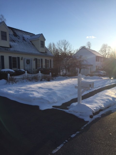
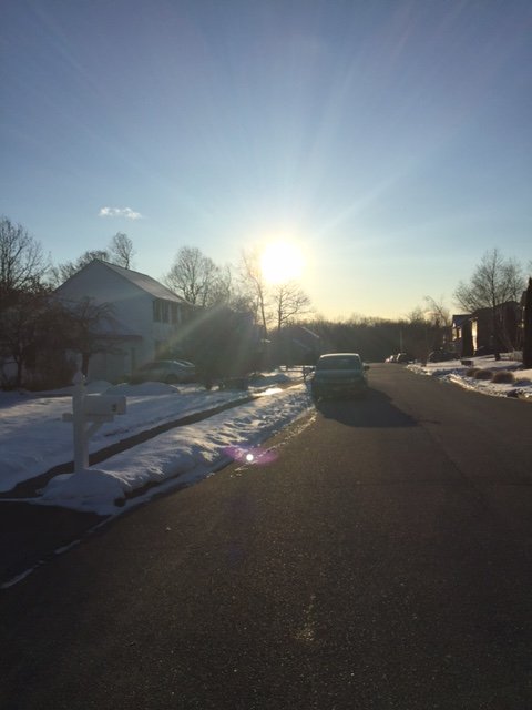
I've posted this pic before....but even down here, this was Thanksgiving 2018. It hadn't snowed for days at this point (that thin layer on top of the older layer was about 3 days old....the thicker older layer was over a week old), but it stuck around like it does in mid-winter and Thanksgiving itself was the coldest November day on record at ORH (and likely many other stationsin New England)....you just don't normally see the snow stick around like that in November. Most November snow melts within a day or two down in SNE or even most NNE lowlands....Randolph, NH at 1500 ft is obviously different.
-
I actually misspoke here....October did in fact have the opposite trend, but they were actually on a negative decadal trend before the 2010s....the 2010s simply brought it back to a flat trend.
-
I was looking at ORH the other day and they haven't broken a record low in September since 1990 (though 10/1/92 did get one....and BOS actually set a record low in September 2013)....30 years. Only December has gone longer (31 years)....I was kind of surprised about December but somehow we didn't break a record low there recently...I was sure we did during 2017, but all those 1933 and 1917 lows blocked them. We saw a ton of record low maxes in December that year, but no actual record low minimums. Compare that to November where we've broken 5 record lows just since 2018. November had been one of the fastest warming months on ORH data through the late 2000s, but now they have been beaten back down so hard with 6 of the last 8 being below normal including two of the top 10 coldest Novembers on record....to the point where November is now just warming at 0.1F per decade. Always weird to see stuff like that. October did the opposite....it had barely been warming on the data through like 2010, but then we just got obliterated with October torches in the 2010s so now it is warming much faster now on the means.
-
Some pretty good cold shots showing up on guidance over the next 10 days....prob 3 legit frost/freeze opportunities (more frost rather than freeze on the first one for NNE) between now and 9/21. I don't feel like we've seen this type of continuous frost threat pattern in September in a while.
-
Getting trained here now
-
You might be thinking of 3/3/94. Massive interior storm. We got about 13-14” in ORH with big wind. Lot of rain for the big cities after some front end snow....though I believe BOS had decent snow (8”+) with some rain/sleet at the height. But the true jackpot was back into interior PA and central NY where 2 feet fell.
-
Mar '56 to your generation was what Dec '92 was to mine (or maybe Mar '93 for those who got shafted in '92)...."The Big one that broke the snow drought" for each generation of kid snow weenies.
-
The Syzygy storm was 1/2/87


