

ORH_wxman
-
Posts
90,902 -
Joined
-
Last visited
Content Type
Profiles
Blogs
Forums
American Weather
Media Demo
Store
Gallery
Everything posted by ORH_wxman
-
The warning criteria snow I received on Nov 7, 2012 was totally fine, but the Oct 29-30 snow in 2011 totally doomed us.
-
Both are inhibiting factors to the length of the season. Severe drought really helps mute the colors too, though the drought wasn't that bad up there compared to some spots down in SE MA/CT/RI. Definitely helps to have a windy rainstorm, though a lot of places were already passing peak by that point in NNE which made it easier to drop the leaves. Down here, we weren't quite at peak yet, so we still had plenty of leaves afterward even though we lost plenty of branches during the derecho.
-
Yeah that early freeze really shortened the season....it may not have muted the colors too much, but it definitely helped the leaves change early and then fall off quickly.
-
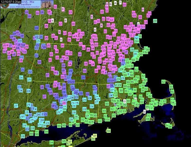
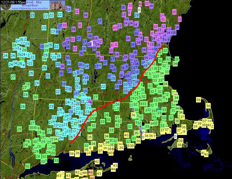
Here's temp maps from the 12/16/07 and 12/21/08 events....Amesbury is just west of the CF on both of them while it's torching (relatively speaking) out on Cape Ann and even in Newburyport.
-
Oct 2007 was an absolute furnace though....so big difference in the CONUS pattern where 2020 will likely finish below normal for a chunk of the plains and midwest/lakes. Prob will still finish above normal here in the northeast as we're going to be east of the best cold over the next 10 days. But that doesn't mean winter can't be similar. There are definite similarities elsewhere and in the tropical PAC.
-
Yeah Rockport is literally like in the water....it's east of Gloucester. Amesbury can frequently be just west of the CF.
-
I think it makes sense....easterlies migrating eastward is going to keep the Nino1+2 and Nino 3 regions colder than otherwise.
-
It is especially true in La Nina....you can sometimes get away with a mildish Canada in El Nino.
-
Those “changeover from W to E” events with NW flow do that even down here. They aren’t that common but I’ve seen places on the west slopes of the ORH hills toward Hardwick and Ware even at lower elevation get 4-6” and then we barely get an inch or two in ORH. They are sometimes to fascinating to watch even though they would drive me nuts.
-
Yeah those west side places are smoking...you can see how well Alex is doing even down at 1500 and change. Cannon always gets hammered on that type of setup.
-
NW flow is def going to favor the straight west side more...especially in changeover events. Those will be pretty rare once winter gets going and most precip is snow, but advecting the cold in from the NW is going to be way more efficient to the west. The Pilot range to your NW prob made it a little less efficient advecting the cold in.
-
Coop guy is 1740 or something. I think 1300 is the elevation down along rt 2. His place is up the slope at 1500.
-
I thought they were both 1500.
-
Yeah this was a classic west slope type system. Still pretty cool to see the differences in real time though.
-
Nice Alex. Looks like your area has a bit more than phin....our first weenie comparison test of an event. Looks like his nest cam has about an inch. Makes sense though because this was a NW flow flipping to snow event. Being on the W side of the presidentials is best for that.
-
The warm anomalies on that map are actually where we want to see them start ramping up in November....eastern Siberia. Hopefully they keep doing so.
-
Those guys have nothing on Centralia, PA.
-
Thing works amazing. Lol. Yeah November is not really a snow month anyway....but I still have zero faith in the weeklies these days. I need to see them go on a hot streak before believing them.
-
Time to break out the shovels!
-
Most of it IMHO is attributable to the AO....the AO region has been much more positive the past half-decade vs the 15 years before that (and especially the 2007-2013 timeframe). Now what is driving the AO? Whoever figures that one out wins the big prize....LOL.
-
Wagons east on Euro compared to 06z
-
There will be a bunch of local businesses crippled because of this. It's very sad. That's just going to be an economic reality of the covid protocols....a bit OT for this thread though. I do not think there needs to be a major limit on skiing though....this just doesn't spread well outside based on a huge sample size now, so I do not see the point. Nevermind when most people are actually wearing masks anyway in cold weather. I can understand limiting lodge capacity. Maybe they are scared of too many people trying to use bathrooms or something in the lodge, but I think if you communicate clearly in advance that lodge spacing will be limited, you don't need to start withholding day passes.
-
Everyone seems to be pretty pessimistic or at least quite cautious. That means it will probably be a blockbuster, lol. Not surprising though, recency bias is a huge factor in expectations. When we were churning out big snowstorms like sneakers at a Nike sweatshop, everyone always expected the next winter to be huge. Everyone also expected that we'd keep seeing the big -AO/NAO patterns we saw 2007-2013 too. Even blaming climate change on it (recall the "low sea ice = -AO" studies that were coming out?)...now that we have been dealing with a relentless +AO recently, the narrative and expectations have flipped.
-
Snow weenies in Nagano just threw their computers out the window.
-
Me too....but not if someone is offering '11-'12 as the alternative.


