

ORH_wxman
-
Posts
90,902 -
Joined
-
Last visited
Content Type
Profiles
Blogs
Forums
American Weather
Media Demo
Store
Gallery
Everything posted by ORH_wxman
-
https://apps.ecmwf.int/webapps/opencharts/products/seasonal_system5_nino_plumes?base_time=202010010000&nino_area=NINO3-4
-
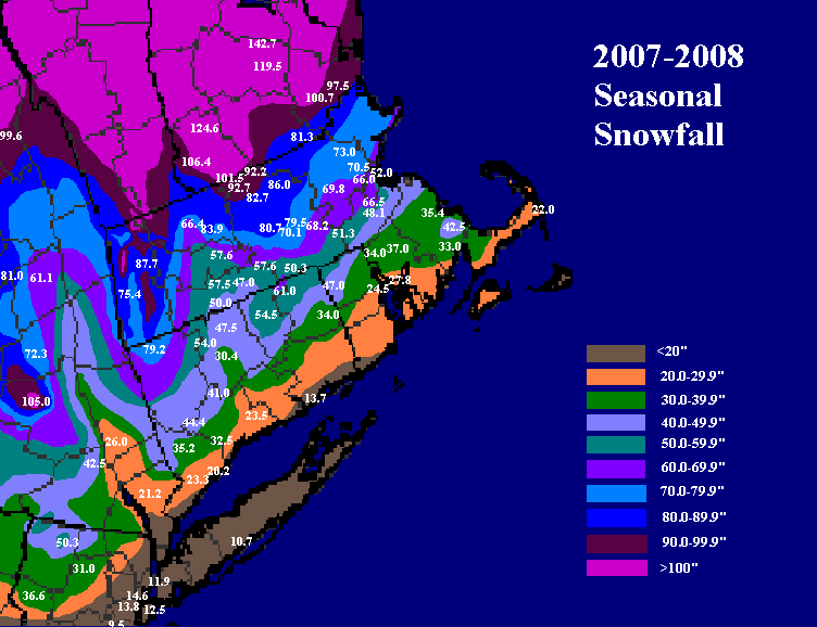
52.0" to be exact. I think they are officially listed as 51.2" because somehow the 0.8" from 12/31/07 never made it into the database even though it was on the PNS, lol. But I have the correct 52.0 on my map.
-
You could argue Logan was low relative to its surroundngs.
-
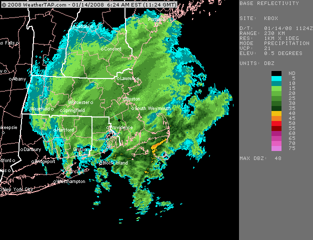
This was actually a nice storm in January 2008....infamous for the huge bust in NYC (almost all rain there when they had a warning out for like 5-8"). I think BOS had about 7-8" and I had just under 10". It was my largest storm of the season....barely (12/16/07, 12/13/07, and 2/22/08 were like all an inch less)
-
Chane the values in the "override default contour interval" feature near the bottom before submitting the map. Go like "interval = 0.1" "High 1.5" :Low = -1.5"
-
Do you have a telescope available to view that gif?
-
Yep. Overrunning storm that basically lasted all afternoon and evening. Mixing tickled the pike late in the event, never quite got IMBY.
-
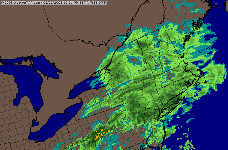
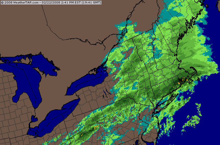
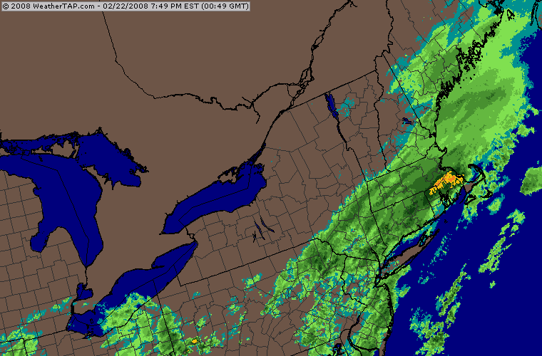
Feb '08 was pretty good in the interior....had the snow to big icing event on 2/13/08 (this event narrowly missed a Dec '08 type disaster), then the big 2/22 storm that got most of SNE with 7-12" and then two more events....a nice overperformer front ender on 2/26 and then the clipper redeveloper 2/29-3/1.
-
Yeah we were prob slightly unlucky in Feb considering it was cold and pretty active still. But then again we kept pulling triple 7s on the slot machine in January so I guess we were due for a few misses. One of these years we’ll keep it going. Might be a one in 200 year type lucky break, but eventually there will be the January 2011 pattern (or feb 2015) and instead of things basically ending, you continue it on a less obscene scale but it drives the winter into unprecedented territory. I sort of picture something like ‘95-‘96 without the 2nd half of January utter meltdown pattern or maybe 2010-2011 where we get a little luckier in February/March. Something like that. Hopefully we’re alive to see it, lol.
-
It was better the further north you went. Pike region got hit pretty hard during the Groundhog Day two part system. There was a big thaw mid-month that lasted 3-4 days for the meat of it. Knocked my pack down from like 38” to 20” or so. There was a pretty good snow to ice back to snow event for CNE on 2/25/11...really hammered over from Brian’s area to southern ME (apparently only moderately fringed tamarack’s area per an earlier post about this storm) where they had a foot-plus in some spots....down here we had like 1-2” on the front end and then had another 1-2” when it flipped back. A lot of ZR in between in ORH. I don’t think there was much down in your hood. Maybe an inch or so but you prob had some ZR for a while. Then on 2/27 there was a clipper/redeveloper that was really good for the MA/NH border region. We had like 3” in ORH but Megan was living up in North Chelmsford at the time and I was actually up there for that event and measured 7.5”. The jackpot was just a tad further north than that from Ray’s current area into SE NH where they had 9” I believe. Big positive bust system up in that general area...a really heavy band blew up as the system was exiting stage-right. Then yet another system the next day started...big icing over interior ORH area we had like 3/8th of ice and started getting a few power issues before it ended as 33-34 rain. Winter basically ended after that around here....there was the really tight gradient WNW to ESE frontal system that hammered powderfreak’s area on 3/6-7 I believe but virtually nowhere else in New England got in on that....the rare almost-exclusively longitude system We did get s few cameo events such as around the equinox and then again on 3/31-4/1 but by then the pack had mostly been eradicated and the winter feel was gone.
-
72/56 here....pretty much perfect weather.
-
Here's some winters that were pretty good La Ninas with a bit of strength to them (i.e. I didn't include weak Ninas like 1995-1996 and 2000-2001 that behaved almost like El Ninos)

-
What about 2010-2011 there? That must have had pretty deep pack.
-
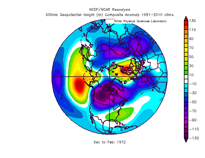
Totally forgot '09....yeah up here we actually had less than the southeast areas on Xmas morning. Prob like 8" or so. SE areas had over a foot probably. Yeah '08 was torched on the coast....I had to pick up my sister in Boston that morning, and drove into bare ground (with patches) while it was still like 7-8" of glacier in ORH. '07 actually survived a bit better on the coast I think.
-
Xmas 2017 was close, but no cigar...it was like 5" on top of 2-3" of glacier.
-
Yeah double digit snow pack on Xmas is rare on the coast...it's not super common here over the interior either though it happens a little more frequently. For the coast, off the top of my head, my guess would be maybe: 1995, 1975, 1970, 1961, 1945?, any earlier is knickers of yore territory and I don't have good knowledge embedded in me on those years....maybe i missed one or two in the late 20th century For a place like ORH, maybe you add on 2007, 2002 (if you count later in the afternoon...only was a couple inches at 7am), and perhaps 1966. Maybe 1960, though that storm had prob settled to below 10" by Xmas.
-
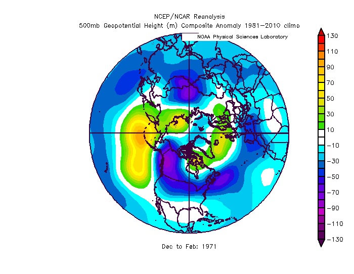
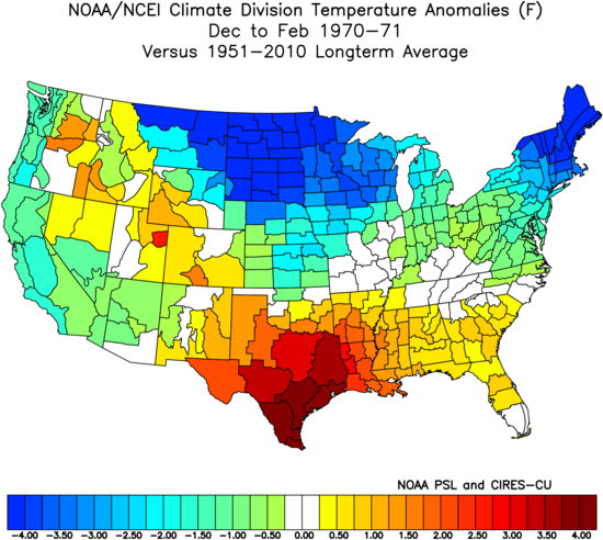
We were prob a little unlucky in Jan '71 but it made up for being lucky in Dec '70. Either way, it was a very solid winter....esp over the interior. The coast had some frustrating periods, esp in Feb '71...and I think there was another snow to ice event in early March too that prob sucked for the coast. It was an epic winter for CNE/NNE though....even just north of ORH had like 30" more snow...and ORH already had 80" that winter. I think the Ashburnham coop had like 105-110" or something.
-
That month had two big ice storms in the interior....a snow to ice scenario. Prob sucked for the coast. I think ORH was near normal snow in Feb '71 but had a ton of ice. I think it was the 2/7 or 2/8/71 that had the big one. Not quite on the level of Dec '08 or Dec '64 in ORH but pretty big ice storm. A lot of sleet saved it from being in the class with those others.
-
The New Years Day '71 system actually got squashed too far south for us....it was NYC's only good storm that winter. I think parts of CT got warning snows, but up in our area it was like 3-5".
-
I just pulled this up....you can see the two cores of cold...one in the typical area of the upper plains, but then a secondary cold max over New England....it was due to the NAO that winter. Prob lots of would-be cutters getting rejected and getting squashed south of New England as redevelopers, so west of the Apps gets warm-sectored on some of those while it never happens over this way...and that winter was super active for storms, so this happened a lot.
-
'70-'71 was absolutely frigid in New England despite the volatility out west. I don't have the exact figures in front of me but ORH went something like this for departures for DJFM.....-7, -6, -1, -5. I think the main reason for that was that winter had a predominately negative NAO with a poleward Aleutian ridge edged toward the WPO side....it's a very cold pattern for Canada, and then throw in a -NAO, it's a very exceptional pattern for New England. It quickly transitioned into above average temps int he southeast US.
-
They are pretty closely correlated so it doesn’t matter that much which one you follow for climate purposes. For “in-season predictions” though, NSIDC area is a much better predictor of both final minimum extent and area when you are a few months out (June/July). That is why I use NSIDC area to make my minimum predictions at the end of June every year. I should mention that NSIDC area is different from other area metrics because NSIDC uses the SSMI/S satellite which gets fooled by melt ponding. So SSMI/S-derived area in June (when melt ponding tends to peak) is really a good proxy for melt ponds which is the true skilled in-season predictor of final minimum extent and area.
-
Oh right. I def remember Eric. I couldn’t tell that was Dave in the very back.
-
From left to right... Bob (BaroclinicZone formerly ETauntonMA), Pickles (StillNofPike or something, lol), Diane (#NoPoles), Steve (Ginxsnewx), Scott (CoastalWx), Will (ORH_wxma), Kevin (DamageInTolland), Ray (behind Kevin, 40/70benchmark), Don (in front of Kevin, Roosta? formerly ARL_MAwx or something), Megan (stratuslove), Garth on far right (coldmiser)....I can't make out the other two in between Garth and Megan. Someone can chime in on them if they can tell.
-
Reducing the bible of snowstorms to such commonplace correspondence is blasphemy.


