ORH_wxman
-
Posts
90,902 -
Joined
-
Last visited
Content Type
Profiles
Blogs
Forums
American Weather
Media Demo
Store
Gallery
Everything posted by ORH_wxman
-
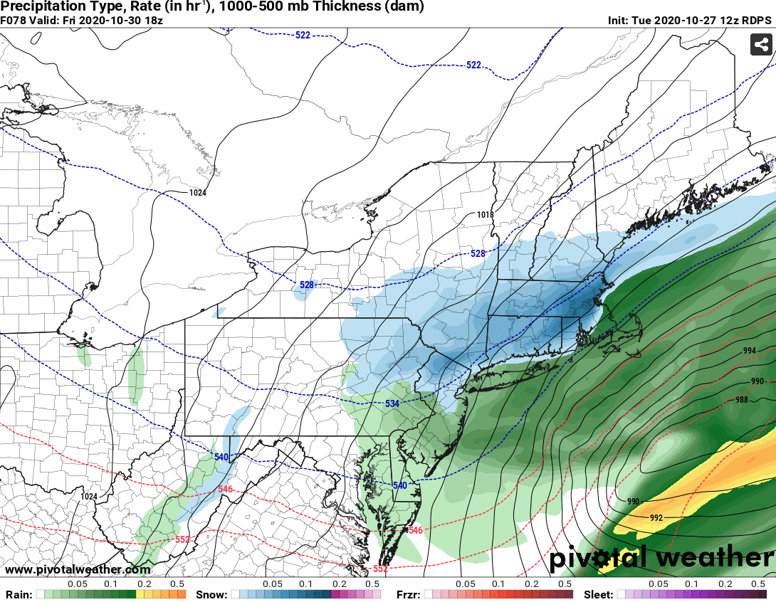
If there was a 69h panel I’m sure it would look good. I didn’t see 72 but I’m sure it would show snow over SNE.
-
Yeah luckily the onslaught ended when it did. We were starting to worry. Incoherent posts at 4am of 03z SREF members and eventually even the old CRAS model made an appearance. LOL....all joking aside, at least in October, it doesn't feel like it hurts as much to miss an event. Of course we all still want it, but we know how anomalous it is and alo there's the entire winter still too look forward to. I'd still watch that lead Zeta shortwave though up in NNE. It's possible you get a few inches from that even if the fronto stuff misses to the south.
-
Powderfreak during the 2015 run started unraveling pretty badly....he started with models like the GGEM but by the 3rd or 4th event that was giving Boston 20", he was down to randomly posting a single ARW SREF member and talking about how great it was for BTV/N VT. You could just picture him with a bottle of scotch looking for consolation and wondering how Boston turned into Stowe. I do think there is still room for some big changes in this one. There's still some reasonable ensemble spread. But I'd think we'd want to see it start happening by tonight or tomorrow morning if there's going to be a big move.
-
I don't have really detailed maps but it did look like the EPS were a little more robust than the OP run.
-
Yep....for ORH it was 5/18/02 to 10/23/02.
-
Yeah like at 66-72, I was expecting a pretty big finishing CCB over SNE on the next frame and then it got crunched and we just get light snows. Either way, that was a positive trend from 06z at least.
-
Ugh...it really shears it at the last second, so we don't get that nice little CCB finish like some other guidance had. It's still there, but kind of weakish on the Euro. Not sure I buy how quickly it shears at the end though. That vort looks pretty good at 66-72.
-
Yeah trough is sharper on the 12z vs 06z run...that bowling ball won't get squashed as quickly.
-
Ray will be snowing before Kevin does most likely. The 850/925 advection clearly shows that.
-
You'd prob get a bit more on the Ukie...2m temps look like they lag too much considering what 925 looks like....it has parts of NE MA with like temps of 37F with a 925 of -4C....lol, that's not happening except maybe right along the shore. But the Ukie loves to do this out to like 495 for some reason.
-
Yes, 00z was super flat...it's more amped than 00z. But it is still on the flat side of 12z guidance.
-
12z Ukie is coming back more amped...which is no siurprise since it was really flat at 00z.
-
GGEM is actually a bit more amped than Reggie...not very common to see that. It really hits CNE hard, but it even gets warning snows down to the pike region. 2-4" type event south of that.
-
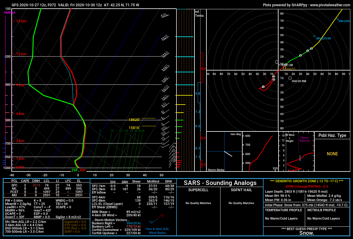
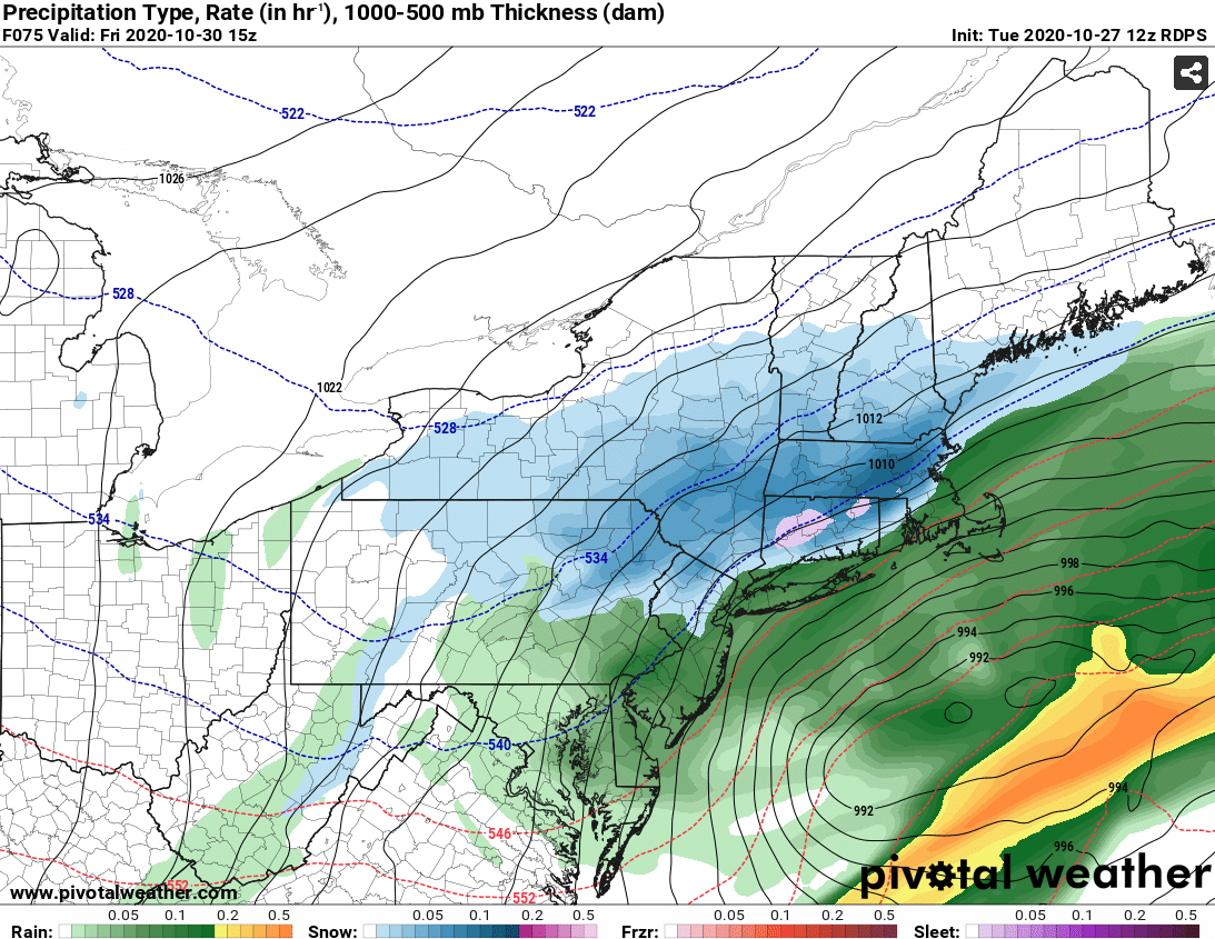
The soundings look good on GFS for Friday morning. Good saturation through SGZ. Best lift is actually like 550-600mb there...thats prob midlevel magic going on.

-
Yeah you'd be close, but prob pick up a couple inches there. RGEM is kind of the "compromise" solution I was talking about with Kevin....in between some of the zonked solutions yesterday and the flatter ones overnight. It's not going to give anyone 18", but you could realistically see some low end warning snow amounts in an RGEM type evolution....esp over interior elevated areas.
-
RGEM even smokes Scooter later on, lol

-
Reggie gone wild
-
Yes...that is the band most folks will want to focus on...if you are way up north like where Phin and powderfreak are, you probably hope some of the Zeta front end stuff hits you for best shot at snow....seems like the backside fronto-band snows are going to be more of a CNE/SNE deal if current trends hold.
-
See above post...
-
It did chew some of the northern precip extent up in NNE....though it was stronger with the CCB down south. Seems like the front side got slightly squished while the backside CCB got a bit better.
-
GFS looks slightly more amped than 06z, but it's pretty similar overall. I think it's a bit snowier than the 06z....slightly better dynamics.
-
Yeah it could be....models never seem to handle super fast flow very well. Esp when critical piece of energy are out over the N PAC or up in blackout land in the arctic where even satellite data gets distorted.
-
The amped runs yesterday gave me more snow than the flatter stuff today. If you are way south in CT/RI then maybe the flatter ones give best chances of flakes and perhaps some light accumulations, but I think even you would want something more amped than the NAM because it will give a heavier burst before exiting....it doesn't need to be like the Euro yesterday, but something in between.
-
I'd sell the NAM clown maps that show 6-8....prob more like 3-6"....still impressive for October no doubt. But this is definitely much weaker dynamics than we saw on yesterday's runs.
-
Yeah, it's a crazy cold airmass lurking for this time of the year. Even though there's potential for higher amounts if this weren't flat, even 1-3" would be pretty amazing.