ORH_wxman
-
Posts
90,902 -
Joined
-
Last visited
Content Type
Profiles
Blogs
Forums
American Weather
Media Demo
Store
Gallery
Everything posted by ORH_wxman
-
Not quite as crazy as last night....though much better than some dud runs overnight/earl this morning
-
Jackpot pike region.
-
Pretty negligible though....very nice period of snow over a chunk of SNE tomorrow AM/midday.
-
Euro coming in a hair flatter than 06z. That 06z run may have been the peak.
-
Yeah some of these models are so cold....then you have the RGEM, lol.
-
pivotal weather will have the euro stuff for free including clown maps. It has most other models too.
-
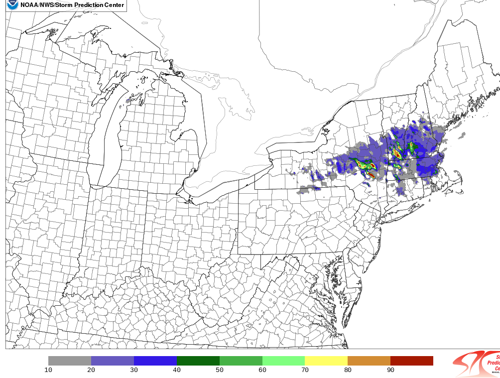
Look at the weenie probability max in blue hills area on the 4 inch probability map on HREF

-
Jeez...GFs is dangerously close to hammering SE MA with a really strong CCB. Eveyrthing kind of slides east at the very last second, but you can see how at hour 24, it's going nuts over LI looking like it might hit RI/SE MA. Still, pretty decent solution.
-
Reggie is still pretty warm compared to other guidance. Doesn't have much down in CT/C-S RI. It is really slow too...it is still light snow hanging on in SE areas at 00z tomorrow evening.
-
Yeah that is a pet peeve of mine...I often tell people. "no, the model did not overpredict the snow, the algorithm that interprets the model data did. Stop using that algorithm....i.e. clown maps"
-
Kuchera map is prob more accurate in this scenario.
-
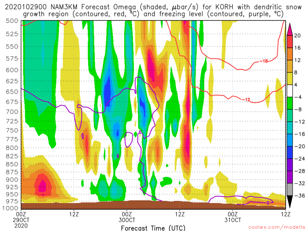
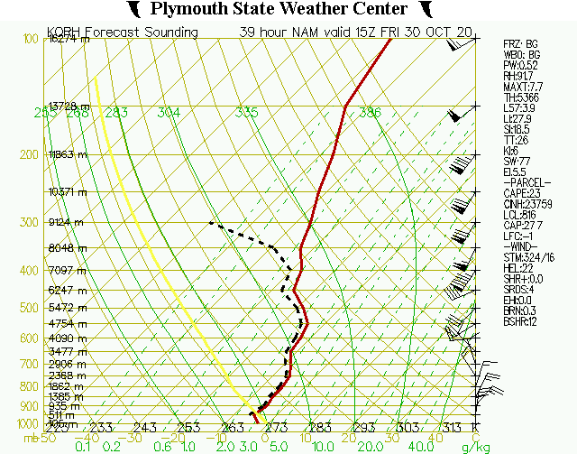
600mb goodies on the soundings. Really cold stuff with -6C getting into that 900-925mb range.
-
Big improvement on the 12z NAM....that looks really good for tomorrow morning.
-
Prob like 3-4" there on that run.
-
Yeah 06z Euro was def an improvement, That looks pretty nice for a large chunk fo SNE. Could see some low end advisory amounts over interior if that panned out.
-
It’s a lot better than 18z. Which is pretty ugly and the flattest outlier so not a surprise it came north.
-
https://www.spc.noaa.gov/exper/href/?model=href&product=snowfall_012h_mean§or=ne You can play around with the parameters at the top. It’s running right now so not out far enough yet.
-
Oh the HREF I think from SPC site.
-
Just one model shown here, but I’ve been noticing it on other guidance too...bit of a crosshair sig showing up for a few hours on Friday morning....we’ll have to watch that. A frequent way to overperform...
-
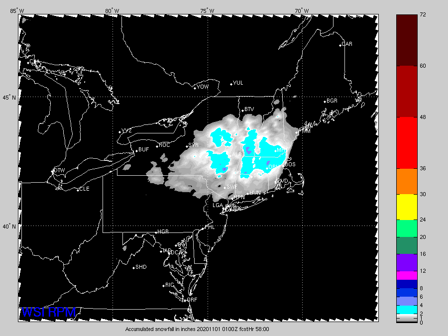
RPM was Jerry’s fetish....gone wild at 00z!
-
RPM?
-
Rgem looks a bit better than 18z. Not as cold as other guidance though. It’s not giving much snow south of the CT/MA border for some reason. Its been that way for a few runs now though on the temp profiles.
-
Those are some nice midlevel goodies on the NAM. Good snow growth look with lift in that 600mb range....and man that is cold in the low levels too
-
Yeah they are somewhat rare...but aren’t that crazy unheard of. We do tend to see them in some of our great winters (Dec 1995 to early Jan 1996 comes to mind as well) We don’t need them that crazy though to have great periods. It would be nice to have some transient blocking that went neutral or only modestly positive in between blocking episodes instead of a straight black hole up there like we’ve often seen in recent winters.
-
I’m guessing where your place is at 1700 feet would see like 2-4/3-5 or so. There’s still a possibility it ends up higher but for now I’d keep it at those levels....I’d want to see another tick more amplified in southern stream before forecasting 6”+. Maybe above 2k or 2500 on the mountain would see 6”+ in the current setup.