

ORH_wxman
-
Posts
93,099 -
Joined
-
Last visited
Content Type
Profiles
Blogs
Forums
American Weather
Media Demo
Store
Gallery
Everything posted by ORH_wxman
-
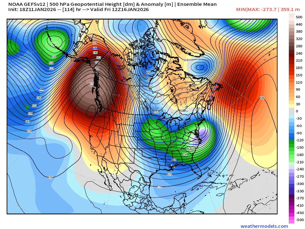
We’ll see what the EPS looks like this run. There was a ton of spread on the 12z eps so this type of solution is within the envelope.
-
Actually brings a pseudo-CCB into Maine that run. That’s how far north it was.
-
GEFS is able to swing that shortwave negative to our south which is what really helps juice that QPF up….prob a lot of members with a full blown CCB into eastern SNE …and not just swing negative, but allow it to gain some latitude while it does
-
Prob a warning event for SE areas that run. Not totally surprising as the 12z GEFS were kind of bullish.
-
January 2026 regional war/obs/disco thread
ORH_wxman replied to Baroclinic Zone's topic in New England
Shit or get off the pot time though for having a AN snow season for anyone who averages over about 45”. If we can score even a couple 4-8” type events, that would go a long way to keeping us in the game. EPS is showing PNA trying to spoke again late month so maybe another window for a coastal there. GEFS more lukewarm on that but it does have a pretty cold look with slight SE ridging. -
January 2026 regional war/obs/disco thread
ORH_wxman replied to Baroclinic Zone's topic in New England
That was the snowiest EPS run for New England in a while. Definitely some chances throughout those two weeks. -
EPS has a decent number of members that are warning snow for a chunk of SNE. Lot of spread of course.
-
January 2026 regional war/obs/disco thread
ORH_wxman replied to Baroclinic Zone's topic in New England
Yep. You get a prolonged overrunning and then you take advantage of a bit of conveyor that gets going as the low goes south of us. -
January 2026 regional war/obs/disco thread
ORH_wxman replied to Baroclinic Zone's topic in New England
That was a pretty nice euro run. Lot of chances. -
Just keep deepening it and good things happen.
-
Man, this is something that is usually eye-opening.
-
January 2026 regional war/obs/disco thread
ORH_wxman replied to Baroclinic Zone's topic in New England
It was a pretty huge hit over interior New England. -
GEFS looks pretty threatening for SE areas and cape.
-
Yeah NH is basically just Canada and CT is fake NYC.
- 583 replies
-
- 12
-

-

-

-
One good thing is that i do like how potent the energy is. Guidance will often dampen/weaken it too quickly. Hopefully a similar scenario here.
-
January 2026 regional war/obs/disco thread
ORH_wxman replied to Baroclinic Zone's topic in New England
Ensembles have an interesting western ridge spike near the end of their run around 1/25. A few of the OP runs have been showing a bigger system around then too. I’d also still keep an eye on potential SWFE type system around 1/18-19 -
Let’s get some positive trends today. Potential is still high even if all these moving parts make it a tough system to expect big snows with. But hell, I don’t even need the double digit upside here, as much as many of us want it, I’d take a solid 5-8” event and hope we can tack on other systems in this pattern.
- 583 replies
-
- 11
-
-

-
January 2026 regional war/obs/disco thread
ORH_wxman replied to Baroclinic Zone's topic in New England
Yeah bark is worse than bite here. -
January 2026 regional war/obs/disco thread
ORH_wxman replied to Baroclinic Zone's topic in New England
Got a bit squashed this run. This is prob the type of system that wont be that stable until we’re inside 100 hours. It’s an imperfect setup with a bunch of moving parts…why it’s still somewhat of a longshot to deliver big snows (not talking a 1-3/2-4 type deal) -
January 2026 regional war/obs/disco thread
ORH_wxman replied to Baroclinic Zone's topic in New England
These are also the types of wins we’d get in the 2010s constantly. Trends that helped us so often in the medium range instead of trending to crap. But when you’re going cold like we’ve been, very few of these work out. -
January 2026 regional war/obs/disco thread
ORH_wxman replied to Baroclinic Zone's topic in New England
Today was also only the 8th day without pack this winter. Most of those days were between 12/8-12/14…had a couple before New Years too. -
January 2026 regional war/obs/disco thread
ORH_wxman replied to Baroclinic Zone's topic in New England
Peaked at 44 here today during the day but 41 now. Midnight high of 48. -
January 2026 regional war/obs/disco thread
ORH_wxman replied to Baroclinic Zone's topic in New England
No those were the squalls you missed. That was actually one of the few overperfomers we’ve had in the last few years, lol. I had like an inch from the regular snow and then got blasted with another 1.5” in like 30 minutes from squalls. -
January 2026 regional war/obs/disco thread
ORH_wxman replied to Baroclinic Zone's topic in New England
Euro is still a bit disorganized but hard to hate that run given the timeframe and what previous runs looked like -
January 2026 regional war/obs/disco thread
ORH_wxman replied to Baroclinic Zone's topic in New England
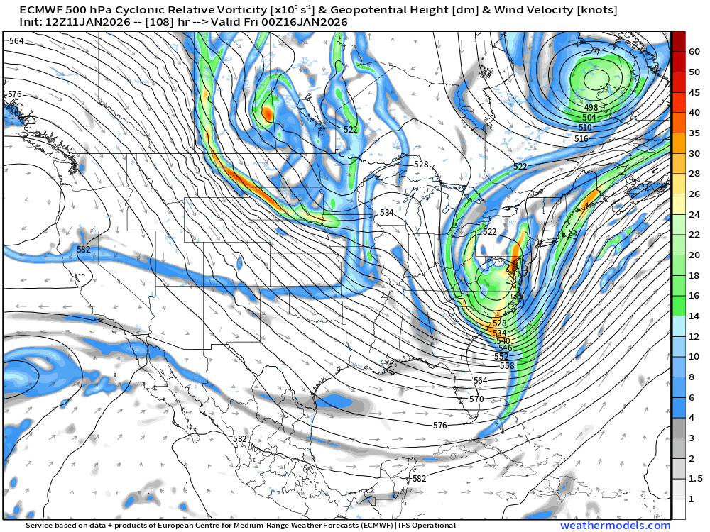
Ok it is gonna be a hit looking at 120h
