

ORH_wxman
-
Posts
90,902 -
Joined
-
Last visited
Content Type
Profiles
Blogs
Forums
American Weather
Media Demo
Store
Gallery
Everything posted by ORH_wxman
-
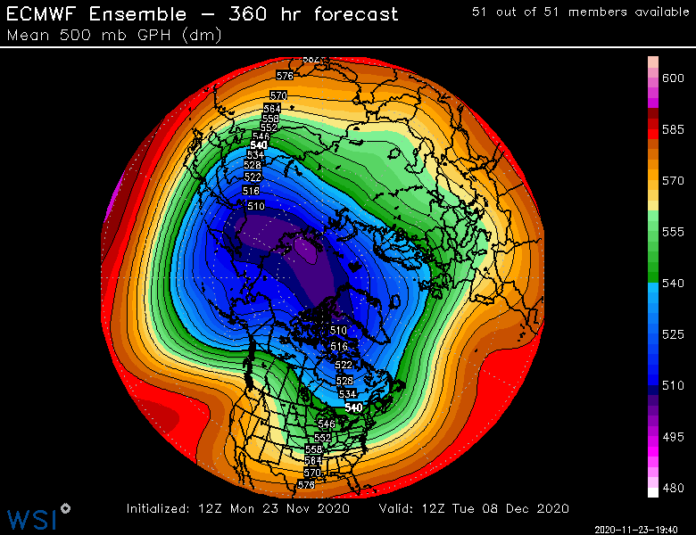
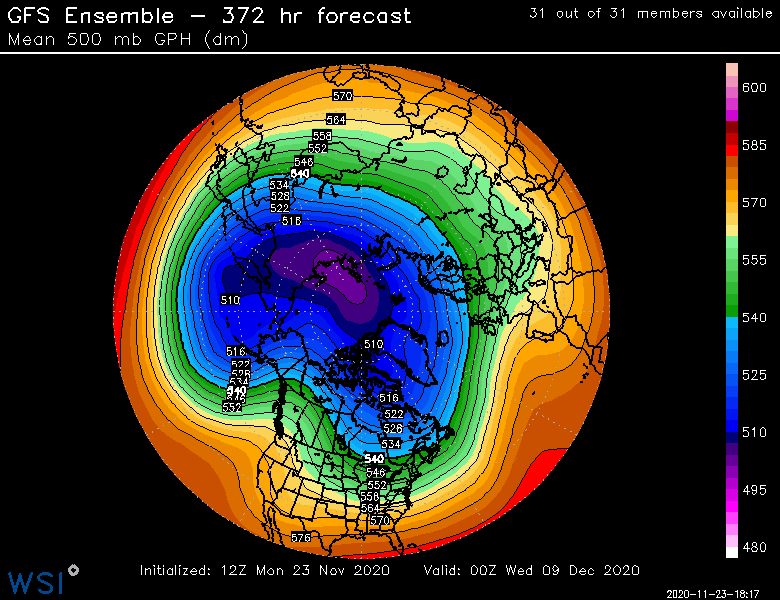
The pattern does get better as Scott said beyond that...it's still not "great", but you'll note how the low heights/vortex has retrograded from AK/Bering Strait back into eastern Siberia/Kamchatka....into a Aleutian Low/+PNA/neutralish EPO pattern. But we'll see...that's at the end of the run once again.
-
Euro ensembles are kind of a mess....not very cold, but there is a chance if things line up perfect. You can see the PNA ridge which has been there all along, but the plethora of waves to the east are kind screwing with the solutions. I agree with you that the stemwinder cutoff in the lakes is unlikely.
-
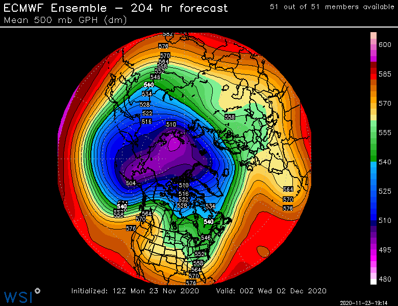
Funny, the Euro is trying to thread the needle the first few days of December. It's an unlikely scenario, but you can sort of see how it would be done....timing the southern stream with a northern stream wave, and that will be marginally cold enough. EPS show a hint of it too.
-
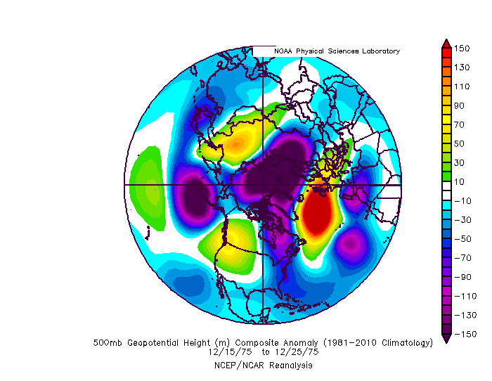
This is actually how December 1975 turned good for New England after starting off the month like garbage. Despite being a strong Nina, we got an Aleutian low and western ridging with a +NAO/+AO. Hopefully we can get something similar
-
This is a pretty solid look if we can reach this.....you actually have some cold replenish happening by this point. But again, this is near the end of the run....granted, it starts to look better by D12ish, but the EPS are still a little grouchier on the idea of that much amplification that soon.
-
Not sure why you keep repeating this...it doesn't look that good. Especially further south where you are. Maybe into the 2nd week of December it's not a terrible look, but the first week looks like crap....you'd have to get lucky from the ULL in early December to get anything.
-
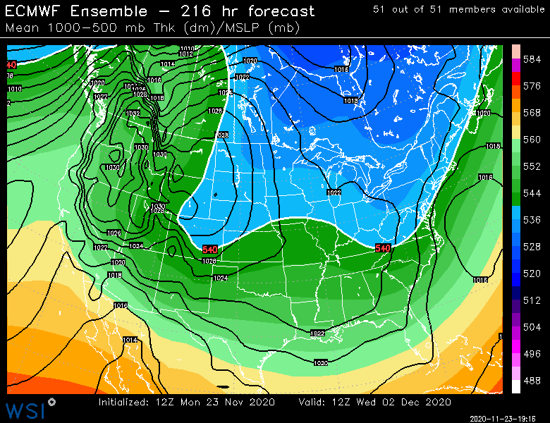
Maybe but the guidance distinctly has a problematic flow into Canada still present in the first few days of December....which it then backs off as we get into the post-12.5 range....now maybe that's wrong and the amplitude out west verifies sharper prior to 12/5....then ok, fine, we could increase the odds of a snow event if that occurred. Obviously the extra 7-10 days of climo also helps if we're comparing 12/2 to 12/11 or something...no denying that.
-
I would say that list is heavily biased after about Dec 6-7. I wouldn't totally argue against something around then or later if we can get that PNA to produce some semi-continental air at our disposal.
-
We could pull something off in first week of December if it is well-timed but I'm definitely not expecting it. It would serve us well to wait for at least a little bit of EPO-easing. We don't need a nuclear ridge there, but we need enough to flush the putrid dreck out of Canada.
-
Nope, Jan 2006 had over 2 feet at ORH...a couple solid warning events (Jan 2-3 and Jan 23) mixed with a couple smaller ones.
-
Agreed. I’m keeping my eye on it closely to see if we don’t really get the better look closer. The last 36 hours has kind of left it beyond d13-14.
-
Yeah I'd be surprised if we got anything decent (say, advisory or better) in SNE prior to 12/10.
-
Yeah I’m not buying first week of December. Too early imho as the air masses are putrid. I mean, anything is possible with perfect timing but I don’t think you are going to get the source region in better shape until post-12/5
-
Let’s hope that’s it instead of 1999-2000 or 2011-2012. Im hoping it’s closer to 1975-1976....garbage pattern for a time in November and the first half of December was repulsive with an AK pig but then it retrograded into an Aleutian low and we rocked the 2nd half of December. Huge pre-Xmas multi-wave event that gave BOS like 17” or 18”. Kind of weird that in contrast to typical Nina, that year produced an Aleutian low for quite a chunk of the winter (a lot of January had one too).
-
Gonna take some time though to reload Canada. First week of December will probably be a furnace across the CONUS even if we’re starting to see some changes in the PAC.
-
Less than 7 months until the sun angle decreases from its peak.
-
This pattern is absolute garbage. Once it becomes a little less hostile (signs of this happening as we go into early December) I’d expect some real threats to start happening for NNE.
-
Yeah anything before 12/5ish is probably going to have very little cold air. Best bet is post-12/10 on that look. Hopefully NNE and upstate NY can get an event or two before that though. It’s in our best interest to lay down some pack there.
-
Yeah down there I think you had 1/7-8/17 and 2/9/17.
-
Yeah feel free to start a new thread for it. Prob the easiest way. Maybe @dendrite can chime in.
-
This is pretty nice. One thing I personally like is seeing a few number values plotted on the actual map but not sure if that’s too difficult if you have so many obs.
-
I gotta find one from like 1/12 or so. I think it went way more nuts. What a disaster that was. For several runs it was basically showing a near-2015 pattern.
-
This isn’t bad at all. We’re going the right direction. Best EPS long range yet...still need to get this closer obviously and even that look is only the beginning of the change.
-
That’s a pretty nice look though if we can get it. Hopefully EPS trend toward that. They’ve been kind of straddling the line between hideous and something closer to GEFS.
-
Last 3 or 4 frames on EPS were encouraging. You could see this big height rise starting near AK/Aleutians.

