

ORH_wxman
-
Posts
90,902 -
Joined
-
Last visited
Content Type
Profiles
Blogs
Forums
American Weather
Media Demo
Store
Gallery
Everything posted by ORH_wxman
-
No it doesn’t. Link?
-
The thing is, ensembles nailed this hideous end of November into early December pattern. Hasn’t been a surprise. I’m just glad that the pattern clearly shows a break and changes after first week of Dec. we’ve had many a winter where it sticks around and then you are screwed.
-
Sounds like dryslot is melting.
-
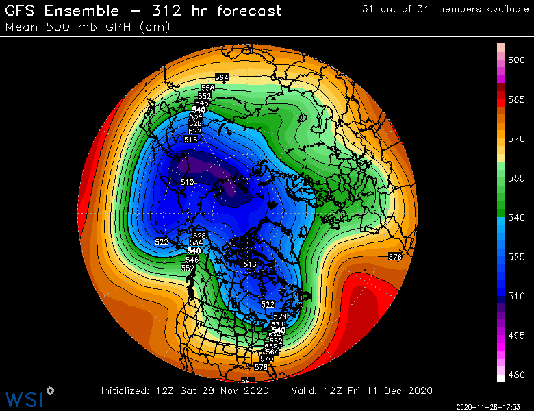
Yep. I’d watch next weekend if I was in a northern greens hamlet or some other typical upslope place that can do well on a CCB changeover with W or NW winds.... but down here we’ll need to hit triple 7s like twice in a row to get something significant out of it in terms of snow. Still some disagreement on exactly how the pattern shakes out after 12/5. GEFS and GGEM ensembles are still more amped out west, though they’ve converged some since last week.
-
I’d have to think 2010-2011 there definitely exceeded 80”. 1995-1996 did too...and prob approached (if not exceeded) 100” that year. ‘02-03 would have probably beaten ‘17-18 as well if we’re just discussing in the past 30 years or so.
-
Yeah I don’t think the attribution studies on the AO/NAO are particularly convincing in one direction or the other when you look at the whole body of literature. There’s certainly a lot more to learn. They are hard enough to figure out on a seasonal scale too.
-
There were research papers just a few years ago that argued melting sea ice was contributing to the severe -NAO/-AO patterns from 2008-2013....but I guess those went out of fashion the last few years. I haven’t seen anything recently about the stronger AO+ patterns though back in the early 2000s, there were papers that argued global warming was contributing to the strong +AO patterns that had become more prevalent in the 1980s/1990s vs the previous couple decades.
-
The upslope potential behind the 2nd system looks pretty decent. You’ll prob get a little behind the first system but the second one might be more favorable for several inches. Still a ways out but it takes a better looking track up into southern Quebec for it.
-
You’ll prob get decent upslope behind the 2nd storm anyway. Gonna need to get lucky for the synoptic stuff to be snow or mostly snow. It’s a hideous setup. Pattern gets a lot better once it passes.
-
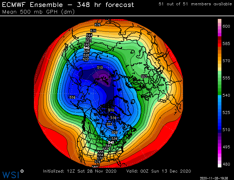
EPS looks like they trended a little more amplified out west in the LR. Maybe a nod toward the GEFS.
-
There’s also still wet snow to the west and southwest side of that low. It’s severely negatively tilted so I’m not seeing how it should snow over us on that setup/track. If we had a fresh arctic airmass Ahead of it then it would be different but this never had that look. Maybe after the ULL moves over we get instability snow showers or graupel type stuff.
-
Hard to hate the pattern on GEFS after first week of Dec. GEFS are starting to hit the NAO region a bit more now too
-
Lol. I’m not sure how many times we posted that the first week of December was probably going to be crap with a garbage airmass. It was at least like 8-10 times between several of us in here.
-
That thing is a hail mary at best. Absolutely putrid airmass out ahead of it. Maybe a little better than a hail mary for NNE, but not by a lot. Really, the better pattern is beyond the first week of December.
-
For selfish reasons, I'm always happy that most people do not follow the Ginxy/ORH_wxman school of thought when it comes to skiing.....ski hard in March. Usually the best conditions of the season are in March at most places. The bonus is that you also are less likely to be in 0F temps with the sun struggling to stay above the horizon at 3pm like you get in late December and January.
-
Yeah openiong day was fine I'm sure because of the timing of the upslope...I'm talking about in general though early on...lots of thaw and refreeze the next 10 days = icy death ribbons
-
Gotta get those runs in on the icy death ribbons. This is why I rarely ski in early season. Even when there is a big snowstorm in early season, the pent up demand usually makes it hard to avoid big crowds unless I play hooky and go during a weekday. But I'm guessing things will be rocking pretty good by Xmas week up in the ski areas if the ensembles are correct. Looks like a pretty good 2-3 week period coming up post-12/5.
-
Yeah both solutions will provide for chances though I think I’d rather have the GEFS look. A compromise would certainly be pretty solid. The split flow look in Canada with all that weakness up in Hudson Bay and N Quebec is def interesting on the EPS. It’s often a look we see in major coastal storms. Only issue is that the cold on the EPS is not overly deep so you get a little less margin for error. But choosing between that look and the GEFS is a good “problem” to have. It certainly beats having a hideous pig vortex up in AK.
-
Yep originally nicknamed the “one eyed pig” and then it just got shortened to “pig”.
-
Split flow with a height max over Hudson is actually pretty damned good. EPS also have a pretty steep +PNA a few days before that so might be some chances in there prior to the 10th.
-
You’d have to think there would be multiple legit threats in the extended with that look. Really good meridional flow.
-
As long as there is no pig, I’m happy with the look. Dec 2008 had a big Aleutian ridge too and -PNA. Both ‘07 and ‘08 did. It doesn’t look like the PNA is going to go negative anytime soon though. Maybe just not as ragingly positive. We’ll see if it starts to revert to more typical Nina -PNA toward later December.
-
Aren’t you west of 495? Lol
-
A ridge retrograding from the PNA region into AK wouldn’t return PAC puke to the CONUS. It would actually encourage more of an Arctic plunge....it just increases the chance that a system could cut if the ridge is further west like that.
-
He’s usually a complete weenie optimist that goes into wishcast mode in winter. I think he’s trying the reverse psychology thing this year after last year’s dud.


