ORH_wxman
-
Posts
90,902 -
Joined
-
Last visited
Content Type
Profiles
Blogs
Forums
American Weather
Media Demo
Store
Gallery
Everything posted by ORH_wxman
-
Nov 1921 repeat next Tuesday?
-
Euro is coming in pretty flat so far
-
I hope....lol....I still think we're prob screwed down here for this weekend, but NNE may end up pretty wintry on this one. But we may have a couple legit threats behind this one. That blocking lingers up in the arctic, so I won't be surprised to see a general trend more favorable during that period.
-
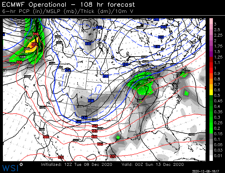
We'll see what the Euro does at 12z....but I'm somewhat on the more suppressed train at the moment where the sfc high builds down. I'd expect the GFS to be the last model to see it. 12z Ukie is building the high in out ahead of the system

-
I fully expect NNE to be locked into the cold at the surface in this one now....the only question iswhether the cold is deep enough so that it is more snow versus more sleet/ZR. Maybe the trend will reverse, but we've seen this movie many times. It will keep trending colder before it does the classic SWFE bump back north inside of 48 or 60 hours.
-
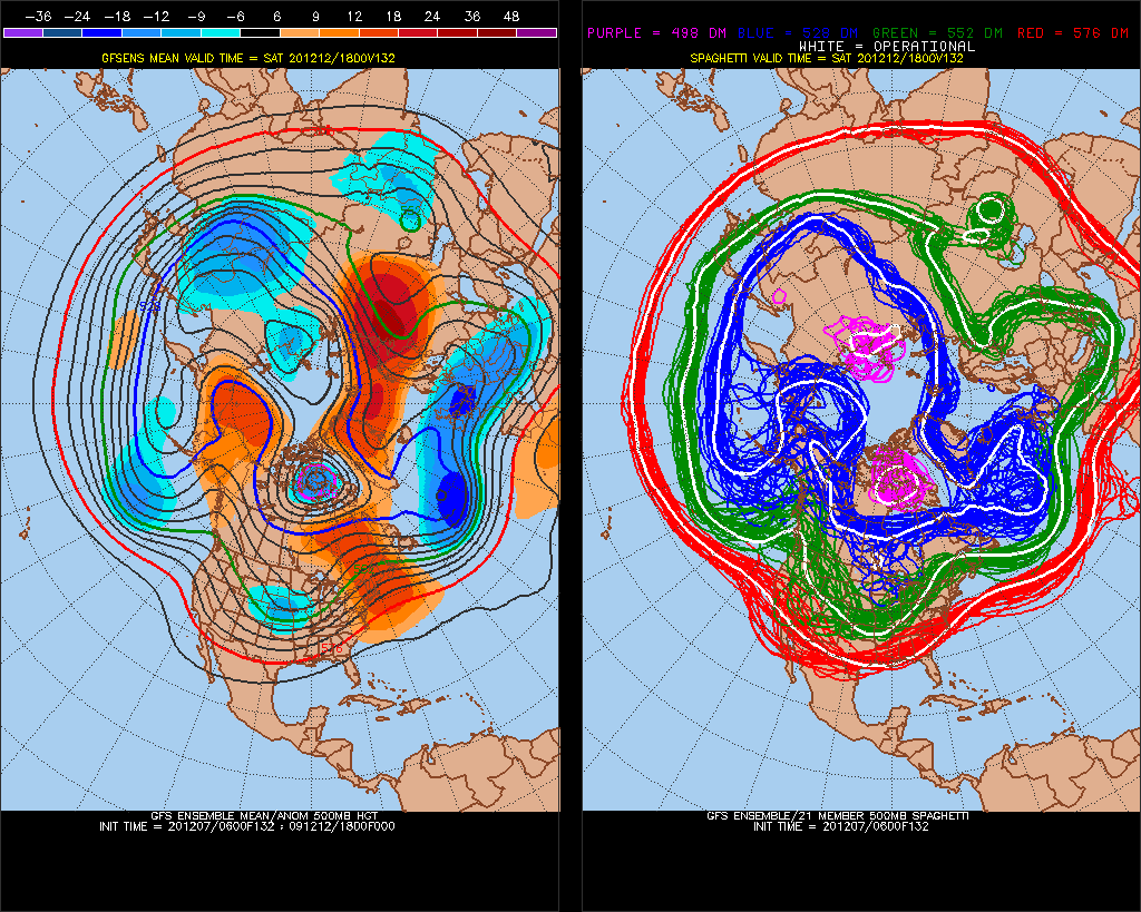
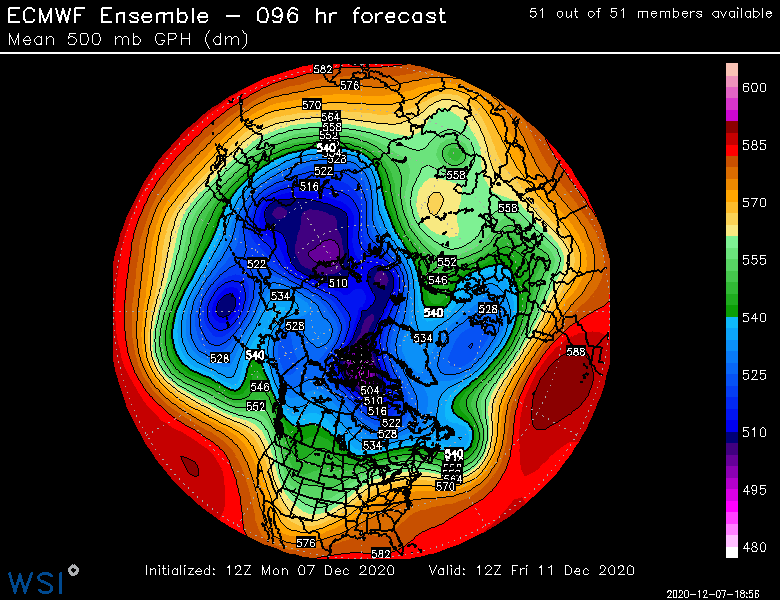
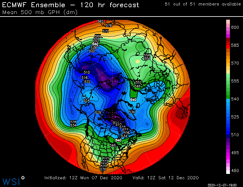
That weekend deal is coming in flatter and flatter each run....the arctic does kind of support stuff trending colder with that...lot of blocking up there right now, so wouldn't be surprised to see further PV lobe pushes south. Below is the 06z EPS at 96 hours. I marked the ridges/blocks in the arctic/subarctic regions that will be important and then the PV lobe that may impact any potential for colder solutions.....we want to force that a bit further south. It has trended steadily south in the past 4 or 5 runs.
-
Megan and I stayed at the evergreen inn a couple times before we had kids when we were doing “budget” Sunday River trips. That place is hilarious. They haven’t changed anything inside since they built the place around 1970. The decor is straight out of that era. Also, when we pulled up, there was always like milk and beer in the snow outside staying cold, lol. Always tons of snow mobiles chained up to the trees out back since the trails have access right to the inn. When I chatted with the owner, he told me how it’s mostly snow mobilers but that they do get some skiers like us too that make the 25-30 min trip to SR or Mt Abram.
-
Meh. I want to also, but it’s a heavy lift to keep us cold enough this weekend. We’ll have more chances behind it.
-
Yes it’s possible. But gonna need to see some trends tonight and tomorrow. We’ve seen the trend of the angle of approach come in flatter over the past 24-36h but it’s still not enough. Need a bigger jump.
-
For a MA hill east of the Berkshires, it has some good vertical. Like almost 600 feet? Its kind of surprising that it couldn’t stay open given the lack of areas within an hour of Boston. I wonder how it would do if it reopened today with some decent infrastructure. I’m guessing it would be viable. We wont find out though. I think it’s like designated wilderness land or something now which would probably make it really hard to reopen a ski area.
-
Can’t really tell this far out. It’s a general N/S gradient. I think it had the dividing line between normal and above normal temps really close to your area for a couple weeks. That should mean chances there anyway if it panned out like that.
-
Weeklies have a decent gradient pattern for late December and first half of January. Low heights in NW Canada into AK but the core of them stay east of the Death Star region so Canada is pretty cold and it oozes into the northern tier.
-
There was a pretty localized event in February 2015 in Boston I recall. I think it was maybe feb 11th or 12th. There was like an IVT with a streamer coming in off Boston Harbor. I rode the train into work that day...back then my office was on the seaport pretty close to Logan. There was sun shining in back bay and Fenway area, by the time I got to south station is was snowing steadily but pretty light. Prob like 3 mile vis. By the time I got to the seaport east of south station there was these perfect LES dendrites falling with like 1 mile vis. I think we ended up with 2 or 2.5” in about 4 hours there while even just north at Logan had about 1.5 and then back west around Fenway they had just a dusting. It was so weird. I think parts just south of where I was near Hull had at least 3”+ of pure 30 to 1 blower powder.
-
That clipper would have some real legs if we didn't have this offshore storm passing us tonight/early tomorrow. Kind of funny, that storm would have probably hit us if it weren't for Satruday's system, and now it's going to cause the clipper potential to be diminished. Wave-spacing 101. Still, if that vortmax is potent enough, we could see some decent snow showers.
-
Wow nice. Watatic still has a lot of very skiable trails visible on it. It's amazing how long they have lasted considering it hasn't been open in over 30 years.
-
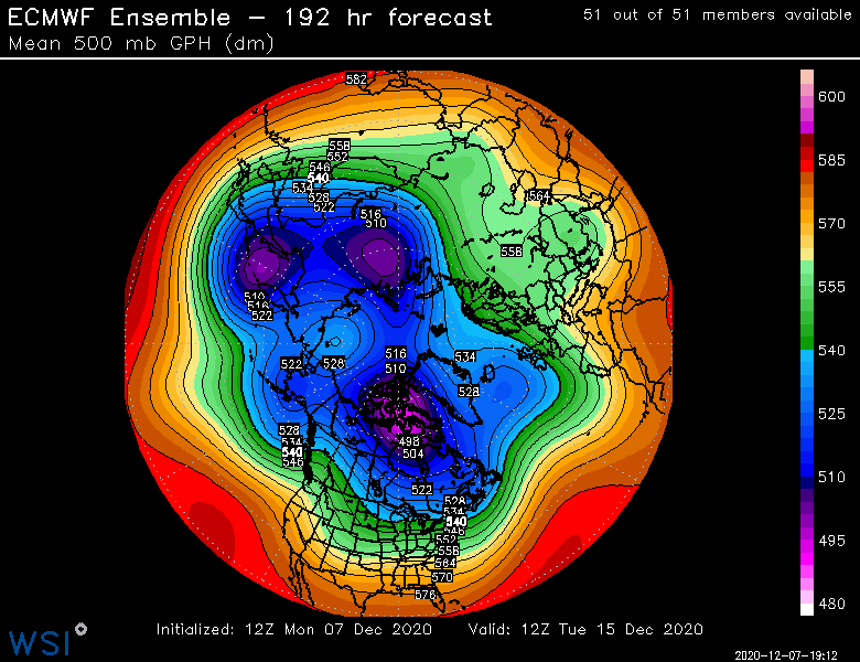
Here is the look by day 8 on the EPS....even though the OP wasn't really interested in producing anything exciting, this ensemble look shows potential. You still have the block N of AK and a lot of cold loading into S Canada, so any disturbance coming out of the middle of the country should be watched....this is why I was thinking somewhere in that Dec 16-19 or Dec 15-20 range could be worthy of a threat. It seems there is a window of synoptic favorability there.
-
Fwiw, and it's not very much, but we could see a lot of snow showers around Wednesday afternoon/evening. That's a decent little shortwave that dives in from the lakes. Prob plenty of upslope posts from powderfreak, alex and phin which should get the juices flowing by the SNE posters. But even down here, there could be some snow showers. There's a little bit of a windexy sounding with TTs approaching 50, but we're lacking LL moisture to really get excited about much else other than flurries with some embedded snow showers mixed in....up in the orographic spots of NNE, it's a different story.
-
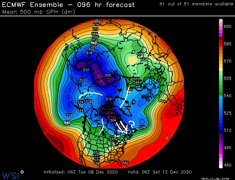
This is a really messy map below (96 hours on EPS and 120 hours respectively)...to agree with your point. I don't think we can write off even the weekend event as a total lost cause. Particularly for NNE. We'd need more help in SNE for obvious reasons, but you can see what is going on there....a block in the WPO region (building and rolling over into the EPO domain) with a pretty soft AO/NAO....almost a "ridge bridge" forming there. You also have split flow out west. Add it all up, and that's the type of look where you can get corrections to colder outcomes. If not enough in time to help this weekend, perhaps the event behind that one.
-
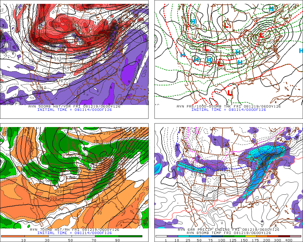
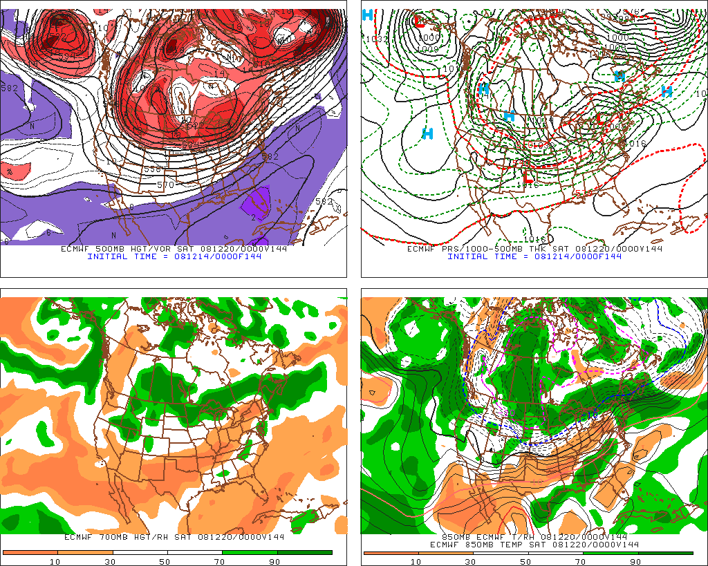
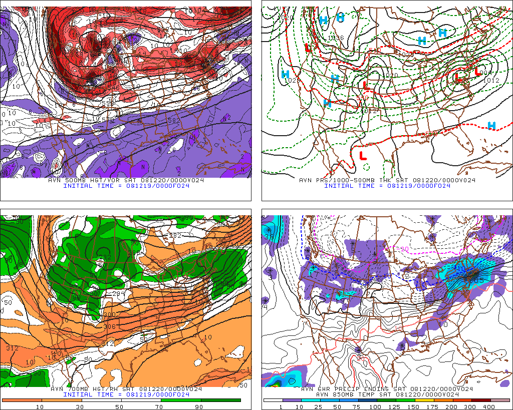
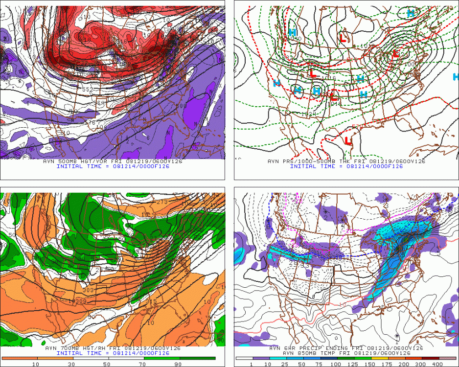
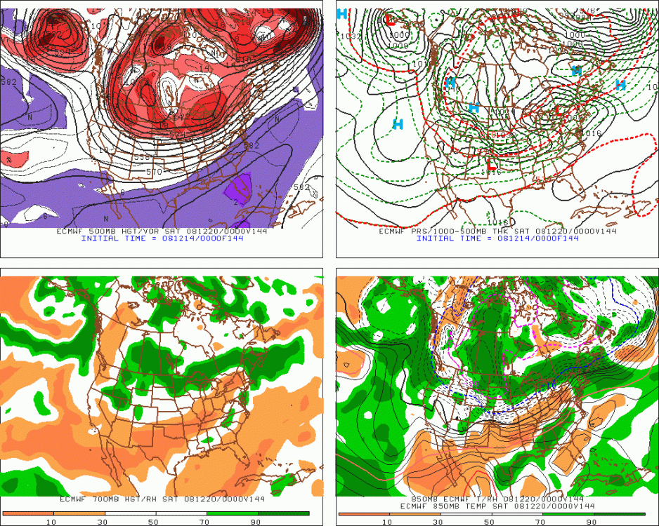
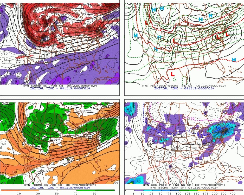
We saw this in Dec 2008....here is the 5-6 day forecast for 12/19/08...the last image was how it turned out. Doesn't alays work out like that of course. That was 12 years ago....but even now the models have a lot of toruble in Nina with blocking up near AK.
-
Almost looks like 12/16/07 with that high location. Maybe shove it southeast just a shade.
-
December 5-6, 2020 Storm Observations and Nowcast
ORH_wxman replied to Baroclinic Zone's topic in New England
I dunno...the max snowfall for the eastern zones in MA was really like 4-8pm on the model guidance....I agree the models did seem to go on too long after that, but the core of the best stuff was forecasted mostly late afternoon and early evening....which from a rate standpoint, largely verified. Maybe we're having two different discussions here..... 1. Did downsloping affect things later on? Yes. The precip after 7-8pm did not really match model guidance which suggested perhaps 2-3 more inches for E MA even at modest 7 or 8 to 1 rations. 2. Was downsloping the main reason for the lack of snowfall accumulation between 4-7pm? No (IMHO). I think our cross sections are explaining that better with the "perfect storm" of toxic brew....as Chris said, the lower elevations needed either slightly more LL cold or for dendrites to overcome the lack thereof, and we couldn't get either. Places like BED and LWM were getting heavy white rain...slamming plenty of precip into the buckets, but just not accumulating it on the ground. -
December 5-6, 2020 Storm Observations and Nowcast
ORH_wxman replied to Baroclinic Zone's topic in New England
I think the lift location is more important than “shadowing” which implies a drying out of the atmosphere. The precipitation was pretty prolific still looking at LWM on the upper 495 belt pretty quickly. I see hourly bucket tips of 0.16, 0.18, 0.12 after 5pm. That is heavy stuff. They just couldn’t accumulate it. It was white rain. -
It's pretty clear that Canada will have some cold....at least for most of the Dec 12-20 period. Less clear beyond that. Now if we can get some timing, then we'll certainly have a chance or two.
-
Yeah Jefferson is still way better than places like Lancaster and Whitefield, but they are on the "same side" of the terrain as them, so that's definitely why there is a notable difference between them and Randolph which is on the other side of those key terrain features. The snowfall seems to really increase once you get into the "curve to the east" part of Rt 2 about a couple miles east of downtown Jefferson.
-
It's not a great pattern but watch that block N of AK....that can sometimes wreak havoc on the modeling as arctic shortwaves dive down east of it and perhaps give us some colder solutions than guidance currently suggests. We've seen that plenty of times in the past....it's basically the opposite mechanism of how when there is a death vortex over AK, we often see things trend warmer the closer to verification we get. You can see the progression of the block N of AK...it eventually retrogrades and weakens, but it is something to watch because that type of block usually biases results a bit colder. Also watch the eastern NAO stuff as well.