ORH_wxman
-
Posts
90,902 -
Joined
-
Last visited
Content Type
Profiles
Blogs
Forums
American Weather
Media Demo
Store
Gallery
Everything posted by ORH_wxman
-
Active mid December with multiple event potential
ORH_wxman replied to Typhoon Tip's topic in New England
Tickled SE a little on the 06z but still there. I’m not convinced yet of more than a C-2” but we watch...id love to grab a couple inches as an appetizer. Maybe we get lucky and it’s a little more. -
Active mid December with multiple event potential
ORH_wxman replied to Typhoon Tip's topic in New England
Notice how it kind of hugs the coast down south and gets warmer midlevel air into NJ but then runs into a bit of a brick wall and moves ENE. Youre probably going to get a hellacious fronto band near on the northern side of that. -
Active mid December with multiple event potential
ORH_wxman replied to Typhoon Tip's topic in New England
06z EPS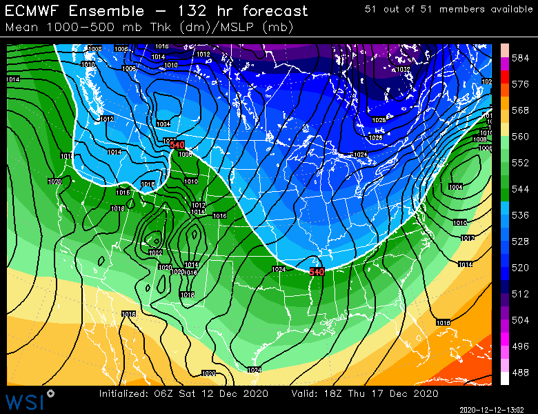
-
Active mid December with multiple event potential
ORH_wxman replied to Typhoon Tip's topic in New England
He sometimes thinks he lives in Pittsburg, NH. He’s in double digits on most guidance and near jackpot in midlevels on a couple runs. -
Active mid December with multiple event potential
ORH_wxman replied to Typhoon Tip's topic in New England
Lol 06z GFS goes insane. Juicier than 00z for most of SNE. -
Active mid December with multiple event potential
ORH_wxman replied to Typhoon Tip's topic in New England
Ukie at 120. By 144 it’s way northeast so we’d need to see 132 but this looks more NW than the more sheered 12z run
-
Active mid December with multiple event potential
ORH_wxman replied to Typhoon Tip's topic in New England
It’s def a miller A on some of these runs where the S/W digs down and then shears a bit. You never get a strong primary into the Oh valley on those runs. I’m still a bit leery though of that considering how potent the shortwave is and going neutral pretty early on. -
Active mid December with multiple event potential
ORH_wxman replied to Typhoon Tip's topic in New England
Canadian showing the H5 pretty strong here...you can see how this can get snow pretty far NW without too much more trending
-
Active mid December with multiple event potential
ORH_wxman replied to Typhoon Tip's topic in New England
Yep. This is the solution when the shortwave gets sheared pretty strongly in the final 18-24 hours. You can imagine the storm making a pretty strong run at that high on runs where it holds together better. -
I think I’d still want to be north of philly on that setup despite the runs today getting the snow pretty far south. The shortwave is pretty amped out in the plains/Midwest so I’m envisioning this thing getting more zonked as we get closer. Though northern MD is as good as anywhere if you’re going to be south of PHL. Doesn’t always happen but there’s a pretty consistent pattern of the storms that get squashed a lot and almost all of them are much weaker shortwaves when they are still pretty far west. One of the exceptions was Feb 5-6, 2010 but that one had a MONSTER block that was way further south than this setup. So unless this shortwave ends up a lot weaker or the fundamental orientation of the block changes, I’d hedge northward bumps.
-
What’s nice is they are starting to get somewhat weenie-ish for 12/20-21 now. Still a long ways to go obviously but that is looking a lot better than it was even a day or two ago.
-
2017 Xmas morning had a nice 4 hour snow blitz across a chunk of SNE.
-
Active mid December with multiple event potential
ORH_wxman replied to Typhoon Tip's topic in New England
Trended southeast from 12z. I mostly expect a non-event for Monday in SNE. -
Yeah....EPS still trying to look a little grinchy around 12/23-12/24 but you can see it's a little weaker this run....12z GEFS really went the other way and basically kept it winter through Christmas. (maybe still trying to hint at a grinch 12/23, but it's almost gone that run)
-
Yeah go for it
-
Near benchmark on EPS at 144...just S it looks like

-
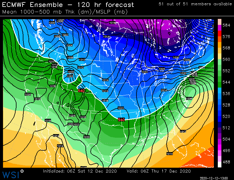
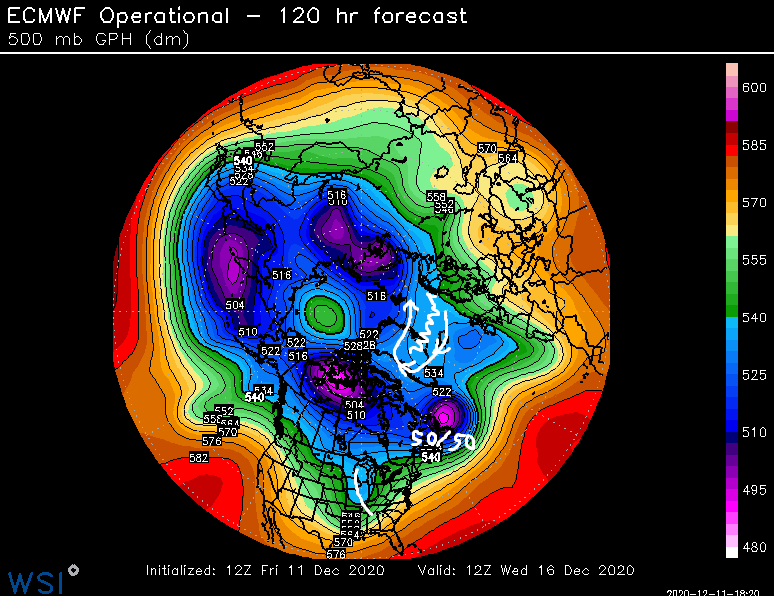
Yeah it is a bit east-based....but it gets the job done. It does poke into the davis strait some. The 50/50 low is VERY potent though which kind of makes up for the NAO block itself being mediocre in stregnth (it's not like we have 560dm heights over Greenland here)...so the conglomerate Atlantic pattern together (both NAO block itself and the 50/50 low) acts as a potent block. The main trough is already starting to go negative in the Mississippi valley which iswhy I think we want this Atlantic blocking
-
Yeah I think that would satisfy just about every SNE poster and probabl many CNE posters. (that is classic ML goodies further NW looking at H5)
-
We're gonna want the blocking....this thing in the middle of the country looks like a cutter normally would.
-
Not this run it won't.
-
Euro has like 2-4 inches over interior for Monday. Maybe even into BOS an inch or two.
-
There's obviously still a decent amount of lead time too. Plenty of chances to screw it up....but I do like tracking the systems better when there's a block like that. It feels a little less precarious. It's very similar to how I felt tracking the 1/12/11 storm. Had this awesome davis straight block and this deep shortwave just traversing the center of the county and it didn't seem to matter really how that shortwave trended because it got squeezed south of us every time. I remember that one basically being locked and loaded on the Euro for about 5-6 days.
-
Yeah i can see that...but I don't think that matters a ton in this situation...whether the wave is a little north or south or stronger or whatever, it still gets "funneled" into the same area because of the block. I mean, that doesn't mean things can't go wrong...if the wave comes in really weak or something, then we might have major problems.
-
GFS/GEFS really looked better at 12z....hopefully that is a true change in the look...it's really asserting the NAO more than previous cycles. It's making the 12/20 system a legit snow threat now.
-
I don't think this is the classic unmanned firehose given the Atlantic blocking....we have some good wiggle room. S/w wants to try and track 75 miles west? still going to run into the block and be forced underneath.