ORH_wxman
-
Posts
90,902 -
Joined
-
Last visited
Content Type
Profiles
Blogs
Forums
American Weather
Media Demo
Store
Gallery
Everything posted by ORH_wxman
-
Active mid December with multiple event potential
ORH_wxman replied to Typhoon Tip's topic in New England
Pete B defended Ray’s measurement on the air in that one, lol. -
Active mid December with multiple event potential
ORH_wxman replied to Typhoon Tip's topic in New England
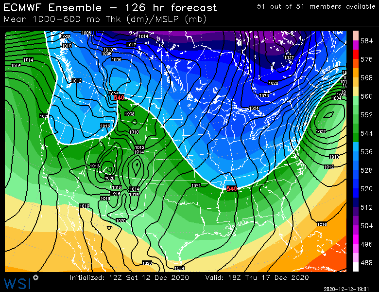
EPS at 120-126. That’s a better look than the OP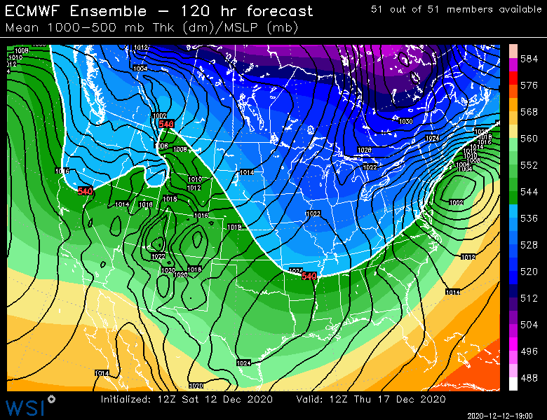
-
Active mid December with multiple event potential
ORH_wxman replied to Typhoon Tip's topic in New England
That and just look at the trough orientation to our west. This is pretty deep and going negative more than any of our whiffs. It’s certainly possible but I’d bet more on a N bump than a S one on that look. -
Active mid December with multiple event potential
ORH_wxman replied to Typhoon Tip's topic in New England
No reason to panic at all because of a single run that is like 75 miles from destroying SNE at day 5. At the end of the day, I’m still pretty sure we’re going to be glad we have a potent block. Hard for me to ignore how this looks to our west. -
Active mid December with multiple event potential
ORH_wxman replied to Typhoon Tip's topic in New England
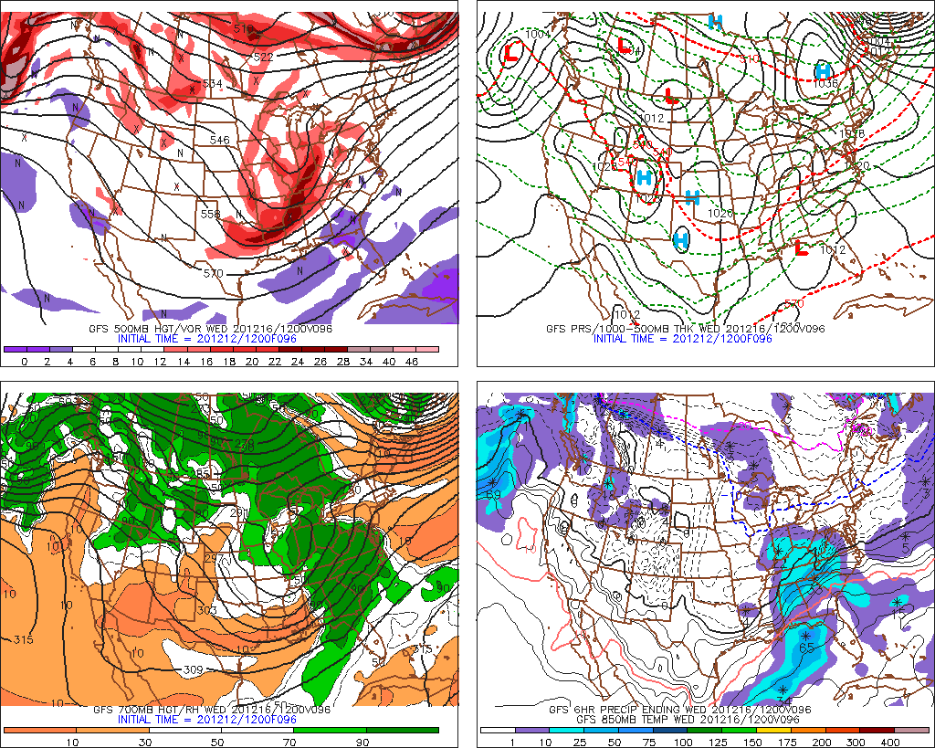
When I saw this map at 96h, I was thinking it could be really zonked.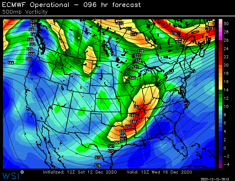
-
Active mid December with multiple event potential
ORH_wxman replied to Typhoon Tip's topic in New England
No you’re thinking of feb 25-26, 2010. Feb 10, 2010 was the epic bust where all the schools and workplaces shut down the night before and we got like 2-3” of slop. Different setup though. It was a deep cutoff low. -
Active mid December with multiple event potential
ORH_wxman replied to Typhoon Tip's topic in New England
After the 850 line was already passing PHL at 108. Color me a bit skeptical of the shortwave giving out that quickly. -
Active mid December with multiple event potential
ORH_wxman replied to Typhoon Tip's topic in New England
Thing was so zonked at 96-102. Then it just dies, lol. -
Active mid December with multiple event potential
ORH_wxman replied to Typhoon Tip's topic in New England
Lol I might ha e spoken too soon. Gets totally shoved east. -
Active mid December with multiple event potential
ORH_wxman replied to Typhoon Tip's topic in New England
Euro def won’t be the Ukie -
Active mid December with multiple event potential
ORH_wxman replied to Typhoon Tip's topic in New England
Ukie is somewhat suppressed and not that potent.
-
Active mid December with multiple event potential
ORH_wxman replied to Typhoon Tip's topic in New England
The Monday storm is a good example of the difference between a nuanced thread-the-needle setup and what is being modeled for Wednesday night/Thursday. You have excellent model agreement 5 days out on the latter threat while you have models all over the map from a 4-6” event to nothing at all on a 54 hour forecast for Monday. -
Active mid December with multiple event potential
ORH_wxman replied to Typhoon Tip's topic in New England
That’s a very good sounding. Classic cross-hair sig. You’d overcome a borderline boundary layer pretty quickly on Monday if that happened. -
Active mid December with multiple event potential
ORH_wxman replied to Typhoon Tip's topic in New England
Not surprising since Reggie wasn’t biting either. Usually if RGEM doesn’t bite, then the GGEM won’t. -
Active mid December with multiple event potential
ORH_wxman replied to Typhoon Tip's topic in New England
There’s definitely a limit. The blocking and associated 50/50 low is felt very strongly. But that main shortwave is going negative fairly far west and it gains some latitude out there too. That’s why I’ve been saying I’d want to be north of Philly...they might be ok there but we’ve seen some runs like the 00z euro which cause ptype issues we’ll into NJ. -
Active mid December with multiple event potential
ORH_wxman replied to Typhoon Tip's topic in New England
This thing’s outta here Thursday afternoon. Maybe some flurries still linger Thursday evening in SE MA but that’s it. It’s a nuke but t doesn’t hang around. For 36 hours like Jan 2015. -
Active mid December with multiple event potential
ORH_wxman replied to Typhoon Tip's topic in New England
It can still come further north before turning ENE. Just look at the upper flow around 96 hours. It isn’t exactly suppression city showing up over NNE...you get that vort a little stronger maybe when it assimilates onshore and you could def see a further north solution. It won’t become a cutter or rip inland over ORH because of the block, but there’s some room.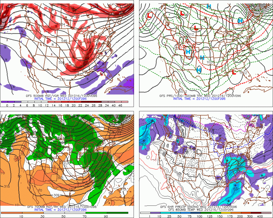
-
Active mid December with multiple event potential
ORH_wxman replied to Typhoon Tip's topic in New England
Just out of curiosity, where do you get Friday from? -
Active mid December with multiple event potential
ORH_wxman replied to Typhoon Tip's topic in New England
GFS is a little mini paste bomb for Monday in SE areas (at least Nw of about GHG to UUU). Could be advisory amounts there. 1-3 gets pretty far west this run. -
Active mid December with multiple event potential
ORH_wxman replied to Typhoon Tip's topic in New England
Some used to refer to storms that start way out to sea and retrograde back in as Miller Cs...I’m not sure if that was just slang or it was actually in the literature somewhere like Miller A and B. I know it wasn’t in the original Miller 1946 paper though. -
Active mid December with multiple event potential
ORH_wxman replied to Typhoon Tip's topic in New England
6-8” of arctic sand for you while Ray whines that he may only get 17” instead of 20” as he misses a mesoband by 2 miles. You know the drill. -
Active mid December with multiple event potential
ORH_wxman replied to Typhoon Tip's topic in New England
Pretty sure “official” depth for the day is always measured at 12z for the first order sites. -
Active mid December with multiple event potential
ORH_wxman replied to Typhoon Tip's topic in New England
The blocking is why confidence is high at D5. Still don’t wanna spike footballs yet but this is a lot different than hoping for thread the needle setups. -
Active mid December with multiple event potential
ORH_wxman replied to Typhoon Tip's topic in New England
That stat can’t be right for snow depth. Do they mean snowfall on Christmas Day itself? (2012 and 2017?) -
Active mid December with multiple event potential
ORH_wxman replied to Typhoon Tip's topic in New England
No it definitely looks more miller A than a couple days ago. That said, it could still go more hybrid f we get some NW ticks as it would result in a stronger primary trying to go into OH valley before the coastal becomes fully dominant. We’ll just have to wait and see. Some of the NW solutions are kind of like that.