ORH_wxman
-
Posts
90,902 -
Joined
-
Last visited
Content Type
Profiles
Blogs
Forums
American Weather
Media Demo
Store
Gallery
Everything posted by ORH_wxman
-
Active mid December with multiple event potential
ORH_wxman replied to Typhoon Tip's topic in New England
Yeah you were really close to where 925mb RH started to drop off on the OP run so near the MA/NH border and northward would start having problems with LL dry air. 12z EPS looked better up there. -
Active mid December with multiple event potential
ORH_wxman replied to Typhoon Tip's topic in New England
Yeah the euro would prob have a filthy band in the pike to rt 2 region based on the MLs -
Active mid December with multiple event potential
ORH_wxman replied to Typhoon Tip's topic in New England
I saw that. So the “about to be defunct” GFS is the one not agreeing with any other guidance. -
Active mid December with multiple event potential
ORH_wxman replied to Typhoon Tip's topic in New England
Just catching up on 12z stuff after being on road all morning. I see the GFS is still clueless. Euro OP went a hair south but still have the zonked NAM and the Ukmet/Rgem/GGEM in between. -
Active mid December with multiple event potential
ORH_wxman replied to Typhoon Tip's topic in New England
Nice...deformed over SNE
-
Active mid December with multiple event potential
ORH_wxman replied to Typhoon Tip's topic in New England
06z euro is going to be more amped than 00z I think. -
Active mid December with multiple event potential
ORH_wxman replied to Typhoon Tip's topic in New England
Amazing how steady the EPS have been. Kind of hard to go against those at the moment. -
Active mid December with multiple event potential
ORH_wxman replied to Typhoon Tip's topic in New England
Lol. 06z NAM has a powderfreak to SYR band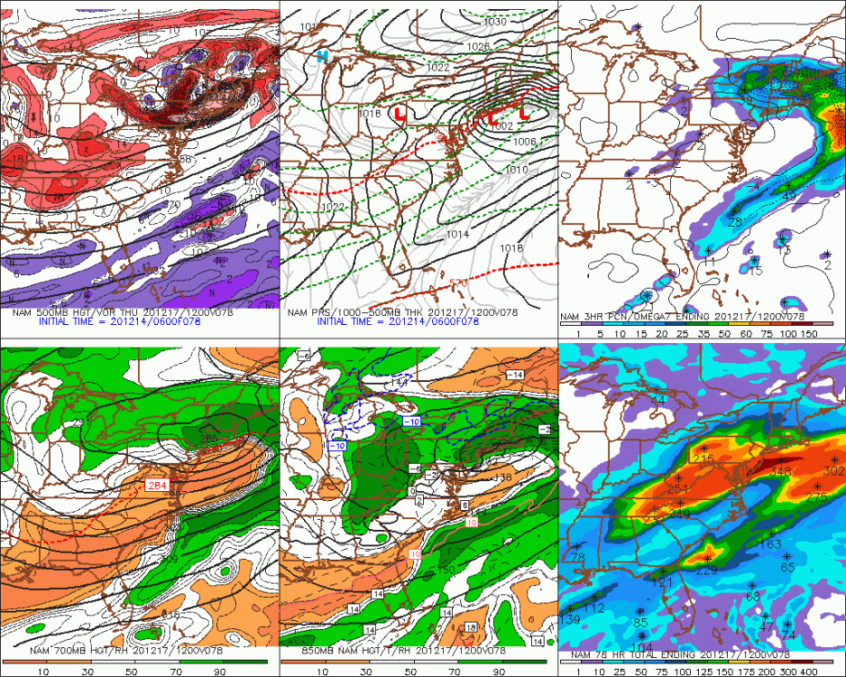
-
Active mid December with multiple event potential
ORH_wxman replied to Typhoon Tip's topic in New England
Both Canadian models were pretty darn fast. -
Active mid December with multiple event potential
ORH_wxman replied to Typhoon Tip's topic in New England
Comparing the pressure pattern (how are the isobars oriented) and the H5 heights, it is significantly more robust than the GFS. -
Active mid December with multiple event potential
ORH_wxman replied to Typhoon Tip's topic in New England
Lol so bizarre. It was definitely more amped through like 48 or 54h. I thought for sure it was coming north this run. -
Active mid December with multiple event potential
ORH_wxman replied to Typhoon Tip's topic in New England
RGEM def a bit more amped than 18z -
Active mid December with multiple event potential
ORH_wxman replied to Typhoon Tip's topic in New England
At least the GFS has the ICON in its corner now. -
Active mid December with multiple event potential
ORH_wxman replied to Typhoon Tip's topic in New England
Rgem is more amped than 18z through 48 -
Active mid December with multiple event potential
ORH_wxman replied to Typhoon Tip's topic in New England
That’s so far N it prob dryslots at least southern parts of CT/RI. -
Active mid December with multiple event potential
ORH_wxman replied to Typhoon Tip's topic in New England
NAM is going to be more amped than 18z -
Active mid December with multiple event potential
ORH_wxman replied to Typhoon Tip's topic in New England
Yes. I don’t think anything drastic should happen since this wasn’t way up north where satellite data is more distorted. But could see some small moves. -
Active mid December with multiple event potential
ORH_wxman replied to Typhoon Tip's topic in New England
Yeah he gets in on it this run. Northern edge of the heavy stuff anyway. -
Active mid December with multiple event potential
ORH_wxman replied to Typhoon Tip's topic in New England
We needed to see 96h for the qpf Queens. Lol. That was stronger than 12z there aloft. Prob gets pretty good snows over border into NH/S VT that run. -
Active mid December with multiple event potential
ORH_wxman replied to Typhoon Tip's topic in New England
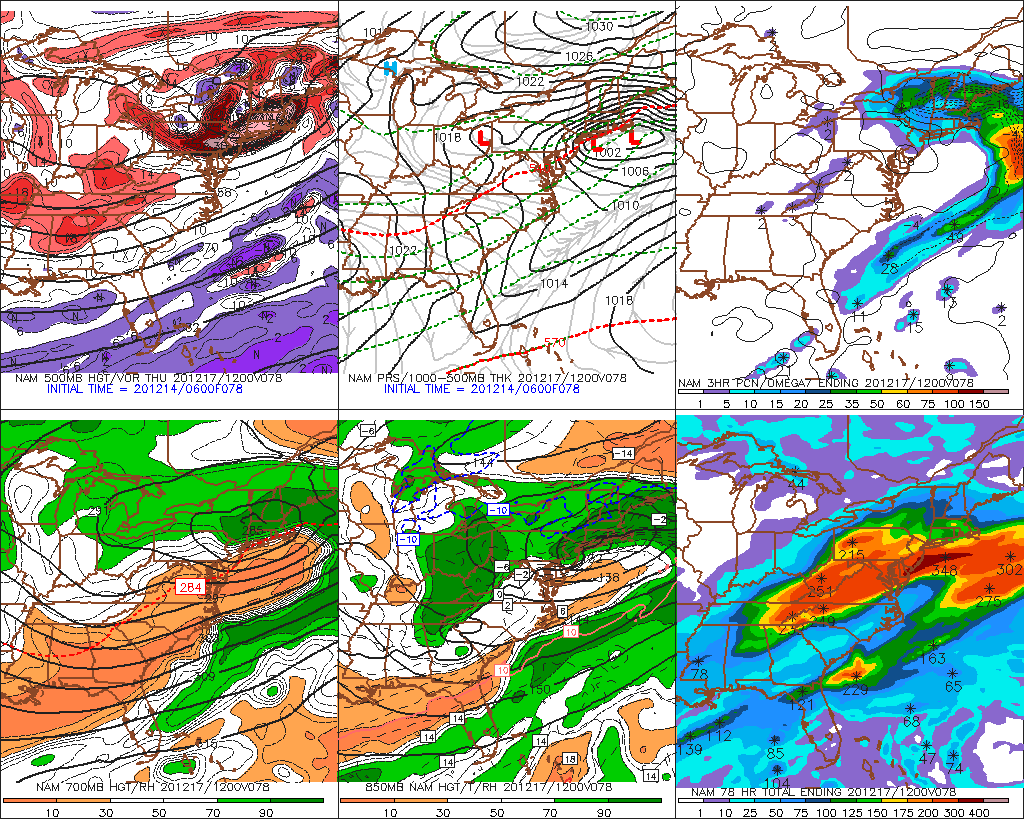
This is a perfect H5 setup for all of SNE pretty much.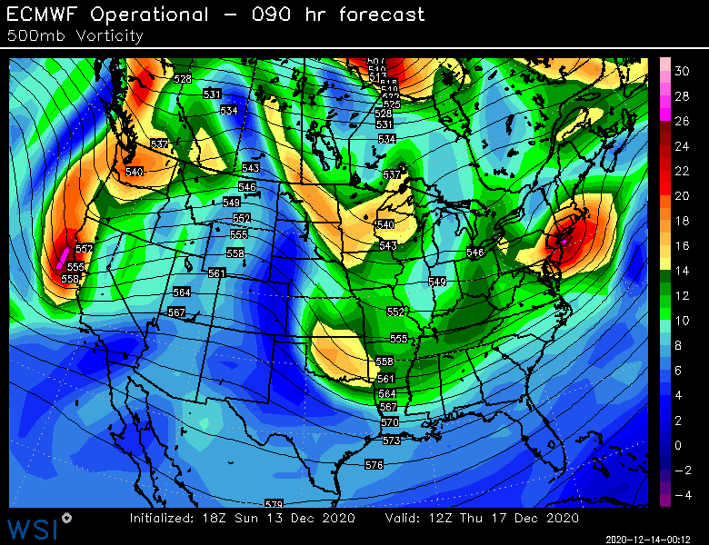
-
Active mid December with multiple event potential
ORH_wxman replied to Typhoon Tip's topic in New England
Runnaway doing naked snow angels at 84-90h. That’s destruction out in W CT -
Active mid December with multiple event potential
ORH_wxman replied to Typhoon Tip's topic in New England
18z euro looks a hair NW of 12z -
Active mid December with multiple event potential
ORH_wxman replied to Typhoon Tip's topic in New England
Correct. It’s not actually in position in the middle of the country yet. It is still offshore. A chunk of it comes onshore tonight and then most of the rest will be on shore by 12z run tomorrow. -
Active mid December with multiple event potential
ORH_wxman replied to Typhoon Tip's topic in New England
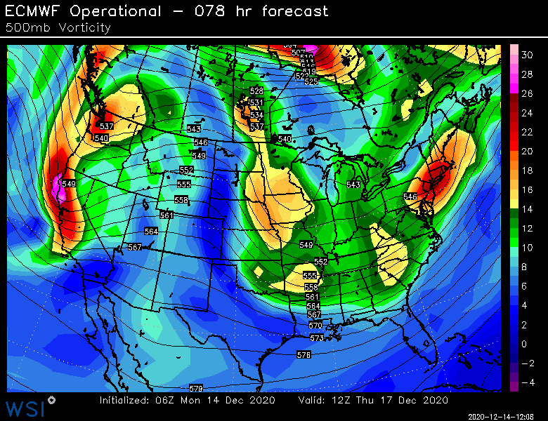
Vortmax is coming in pretty far west. Even compared to previous storms that got crunched for BOS like Dec 20-21, 2009 or Jan 2016. Often the models underestimate latent heat release to the east of them which is why ticks north on huge systems are somewhat common. They can be offset by huge blocks but a lot of the confluence on these past storms (with further east vort maxes) was significantly more than the current threat we’re seeing. So add it up and I’d favor more bumps north than the other way around. Most of the spread on ensembles is to the north too which is suggesting that there’s more room for small initialization errors being corrected to produce more northerly results. Forecasting a big probability game. It’s maybe something like 50% it trends north, 30% chance it roughly stays the same, and 20% it trends south. You can’t ignore the 20%. 1 out of 5 happens plenty of times. But you will pay more attention to the 50%. -
Active mid December with multiple event potential
ORH_wxman replied to Typhoon Tip's topic in New England
PDI was back when the LFM was the cream of the crop. Lol