ORH_wxman
-
Posts
90,892 -
Joined
-
Last visited
Content Type
Profiles
Blogs
Forums
American Weather
Media Demo
Store
Gallery
Everything posted by ORH_wxman
-
December 2024 - Best look to an early December pattern in many a year!
ORH_wxman replied to FXWX's topic in New England
@CoastalWx you’re right about Miami. There was also a snow game the following week but it was against Jacksonville. Snowed pretty good in the second half of that game. -
21z trend is hot right now. RAP and SREFS coming NW…who needs the Euro and GFS?
-
December 2024 - Best look to an early December pattern in many a year!
ORH_wxman replied to FXWX's topic in New England
12/14/03 was a big front ender changing to sleet and eventually rain on coast (good amount of icing in ORH in that) and it was on a Sunday. -
December 2024 - Best look to an early December pattern in many a year!
ORH_wxman replied to FXWX's topic in New England
December 14, 2003 I think was a snow game Vs Miami. -
The rap has been hideous most of today but the 21z run decided to bump well NW. We’ll see if the 00z runs make any attempt to follow suit. Even 25-30 miles could make a decent difference. I don’t think those crazy double digit totals are going to come back but if you move the forcing NW a tick then there could be more low end advisory amounts.
-
Then fast-forward 8 months the same year…unreal positive bust over interior for 12/23/97
-
Feb 24-25, 1989 was the first massive bust I remember and you could see it coming in real time even as a young elementary school weenie. The snow was originally supposed to start that Friday night or predawn Saturday morning. I was watching the evening news and they said it was only snowing on parts of LI and the immediate NJ shore but that we should eventually get into the heavy snow during the day on Saturday. That was the first “hint” that things weren’t exactly going as originally planned. Then I wake up Saturday morning to overcast but it was kind of thin. You could see the disc of the sun at times. The local noontime broadcast showed snow on the Cape. It was snowing lightly with a few inches there but we have bare ground still. Then Barry Burbank comes on at noontime weather segment and says the snow might not start until late afternoon. This is when I started getting that pit in my stomach. I think I stared at the spotlight out back for almost two hours straight between 6-8pm without seeing a flake in the beam of light. Then I finally saw a few weenie flakes before bed around 830-9pm. It snowed all night and finally stopped about mid morning. The storm still ended up a bust but at least we didn’t get shutout like many others I would learn only years later. We finished with about 4” of arctic sand after the original forecast on Friday had been 1-2 feet. Parts of the cape verified with double digits.
-
December 2024 - Best look to an early December pattern in many a year!
ORH_wxman replied to FXWX's topic in New England
Yeah the euro has been more consistent with light snows. I think it maybe had advisory snows for a run but it’s been mostly in that 1-3” range except last night when it went with flurries. GFS has been all over the map from warning snows to nothing. -
December 2024 - Best look to an early December pattern in many a year!
ORH_wxman replied to FXWX's topic in New England
Lol I wouldn’t get too excited but it’s a band of 1-2”….it would at least give a good chunk of the area a White Xmas -
December 2024 - Best look to an early December pattern in many a year!
ORH_wxman replied to FXWX's topic in New England
Euro likes Xmas Eve over SNE. Looks better than last nights run. -
RGEM moving east too...12z suite definitely saw something that is causing the eastward bump.
-
The 06z Euro is more impressive than the NAM now
-
One more bump NW at 12z puts much of eastern zones in the CCB. But can’t afford any regression on the trend.
-
The CF enhanced area seems to be showing up a lot. Euro hasn’t really bought it yet…at least not to that extent.
-
The old SREFs made up of ETA and RSM models were actually half-decent synoptically. The newer stuff with ARW and NMB members are really good with short term convection but they go crazy synoptically. Just not their design.
-
18z GFS isn’t any better either. It still has that CF enhanced area and introduces a bit of PVA to maybe help out. But the main goods are still comfortably offshore unlike NAM and short range stuff.
-
December 2024 - Best look to an early December pattern in many a year!
ORH_wxman replied to FXWX's topic in New England
Only stretch on record where ORH managed 3 winters of 100”+ in 4 seasons. (We came close to repeating that between 2000-01 and 2004-05 when we did 3 out of 5) -
Cape and adjacent SE MA gets a grazing blow from the CCB. Prob a moderate event there
-
Oh jeez. Just when we’re trying to let go of the larger solution. This run very well might get the CCB into SE areas.
-
December 2024 - Best look to an early December pattern in many a year!
ORH_wxman replied to FXWX's topic in New England
We develop a defacto west based -NAO though shortly after Xmas, so I wouldn't be shocked to see some blocky/wacky solutions between now and then. Here's today's Euro between D8-11....you can see all those higher heights up in Canada expanding into the NAO domain....its not your classic NAO ridge back building from the Atlantic, but it may still offer some chances for storms provided the colder airmass gets trapped a bit underneath it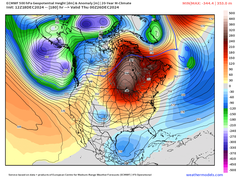
-
December 2024 - Best look to an early December pattern in many a year!
ORH_wxman replied to FXWX's topic in New England
Good luck....I'd prob go a C-1" there....leaning toward C at the moment. -
December 2024 - Best look to an early December pattern in many a year!
ORH_wxman replied to FXWX's topic in New England
Yeah that looks mostly like white rain....maybe if you got above 1200 or 1500 feet it would be better, but that's not what you want to see for accumulations.