

ORH_wxman
-
Posts
90,902 -
Joined
-
Last visited
Content Type
Profiles
Blogs
Forums
American Weather
Media Demo
Store
Gallery
Everything posted by ORH_wxman
-
Active mid December with multiple event potential
ORH_wxman replied to Typhoon Tip's topic in New England
You look like you're gonna get some really good snow growth for a time in the ML goodies. -
Active mid December with multiple event potential
ORH_wxman replied to Typhoon Tip's topic in New England

-
Active mid December with multiple event potential
ORH_wxman replied to Typhoon Tip's topic in New England
Waited until the final run before the storm. That's a good look though in all seriousness....good CCB action tomorrow AM...really cranking for your hood too. -
Active mid December with multiple event potential
ORH_wxman replied to Typhoon Tip's topic in New England
The problem with the algorithm is that even if the max lift is below the DGZ, it is still saturated above that up to like -10 or -11C....that's not even close to being sleet. You're gonna get seeder-feeder easily. If the air went dry above the -5C layer, then maybe it could be sleet....but even then, we are SNE and stick out into the ocean, so we have a lot of salt nuclei available and ice crystals can form with salt nuclei at much warmer temps. -
Active mid December with multiple event potential
ORH_wxman replied to Typhoon Tip's topic in New England
Yeah I don't think it would do a ton back as far west asbyou are, but it could add enhancement in the form of extra frictional convergence in eastern areas tomorrow AM....just something to watch. -
Active mid December with multiple event potential
ORH_wxman replied to Typhoon Tip's topic in New England
It looks like the GFS is tapping some of the convection moisture into the conveyor belts better....it is notable in E MA/RI this run. Some of the guidance (including the GFS) is developing a bit of a lower-midlevel firehose from the east tomorrow morning....like 300 mile fetch at 40-50 knots) -
Active mid December with multiple event potential
ORH_wxman replied to Typhoon Tip's topic in New England
I think it will be slightly east of 128....but the CF won't be stationary very long, it's going to collapse SE pretty quickly after about 10z. -
Active mid December with multiple event potential
ORH_wxman replied to Typhoon Tip's topic in New England
I actually just did it -
Figured I'd start this up....snow won't start in our forum until this evening (perhaps as early as 4-5pm in far SW CT)
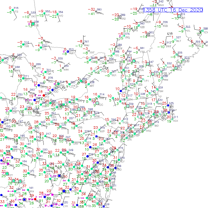
-
Active mid December with multiple event potential
ORH_wxman replied to Typhoon Tip's topic in New England
It did do the weaker QPF thing again on the front end, lol. Though not quite as big a dropoff as previous off hour runs. -
Active mid December with multiple event potential
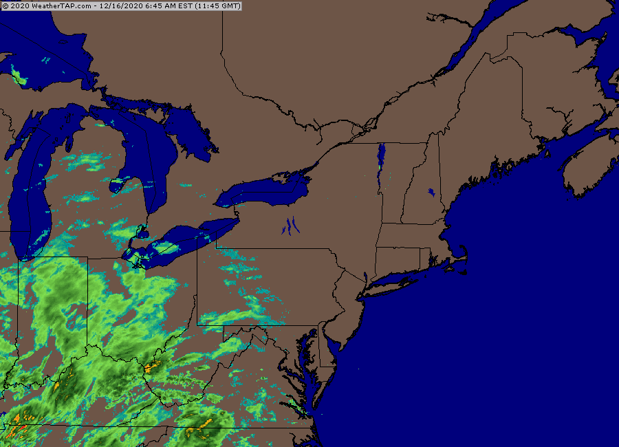
ORH_wxman replied to Typhoon Tip's topic in New England
06z rpm (09z is still running)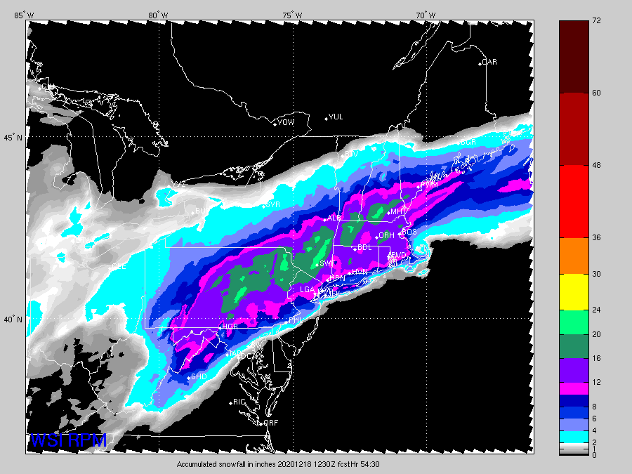
-
Active mid December with multiple event potential
ORH_wxman replied to Typhoon Tip's topic in New England
At least you will return back to a good pack in NH. Might pick up some decent snow out of this one after it looking like a clean whiff a couple days ago. -
Active mid December with multiple event potential
ORH_wxman replied to Typhoon Tip's topic in New England
That’s pretty weenie-ish considering it’s not done yet at 12z. Could prob tack several more inches on. Esp out east. -
Active mid December with multiple event potential
ORH_wxman replied to Typhoon Tip's topic in New England
One thing that is a continued trend at 00z which started at 18z is the conveyors are looking better organized. It looked that way on the NAM and also on the rgem. -
Active mid December with multiple event potential
ORH_wxman replied to Typhoon Tip's topic in New England
Here’s the final RPM weenie map for Jerry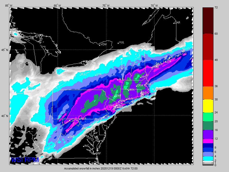
-
Active mid December with multiple event potential
ORH_wxman replied to Typhoon Tip's topic in New England
Yeah Cory...3k often really jacks up coastals probably due to latent heat feedback on convection pumping heights up. -
Active mid December with multiple event potential
ORH_wxman replied to Typhoon Tip's topic in New England
The scooter convection getting entrained a little? Kind of looks like t this run. That is ridiculous over your hood around 06z-09z -
Active mid December with multiple event potential
ORH_wxman replied to Typhoon Tip's topic in New England
NAM looks a shade SE of 18z so far through 24h -
Active mid December with multiple event potential
ORH_wxman replied to Typhoon Tip's topic in New England
That’s like a perfect track for a lot of SNE. Hopefully there isn’t too much exhaust and the CCB and WCB are more linked together than some guidance shows. -
Active mid December with multiple event potential
ORH_wxman replied to Typhoon Tip's topic in New England
Yeah the cutoff line was near ginxy. -
Active mid December with multiple event potential
ORH_wxman replied to Typhoon Tip's topic in New England
I think one of my favorite Harvey broadcasts was the day before the January 2015 blizzard. He just totally weenie’d out on the air and said something like “These are the types of storms we live for as meteorologists.” You could hear the excitement in his voice. That’s when I was thinking “he could totally do this another ten years. He still has the passion” -
Active mid December with multiple event potential
ORH_wxman replied to Typhoon Tip's topic in New England
Yeah that was his first coup...he’d only been on the job less than a year and then he was the boldest for the ‘78 blizzard forecast....he was right and then the rest is history. I hardly ever missed a forecast from him in the winter when I was in elementary school in the late 1980s and early 1990s. -
Active mid December with multiple event potential
ORH_wxman replied to Typhoon Tip's topic in New England
Off hour QPF Queen run again. So weird how the off hours on euro have done this every time in this storm. It actually looks like the CCB is a bit more organized this run though for the second half of the storm regardless of the QPF maps. -
Active mid December with multiple event potential
ORH_wxman replied to Typhoon Tip's topic in New England
18z euro looks a tick more amped than 12z through 24h -
Active mid December with multiple event potential
ORH_wxman replied to Typhoon Tip's topic in New England
Jerry RPM fetish 21z run came SE. pretty darn good run for most of SNE and CNE


