

ORH_wxman
-
Posts
90,902 -
Joined
-
Last visited
Content Type
Profiles
Blogs
Forums
American Weather
Media Demo
Store
Gallery
Everything posted by ORH_wxman
-
Significant upper middle Atlantic S/CNE mix/snow potential Jan 3+
ORH_wxman replied to Typhoon Tip's topic in New England
FWIW, there IS a high pressure system in a decent spot, it's just not very cold. But it does help feed dry air into the system. This was something lacking in the 12/5 system which really made the marginal airmass hurt more...esp for lower elevations. -
Significant upper middle Atlantic S/CNE mix/snow potential Jan 3+
ORH_wxman replied to Typhoon Tip's topic in New England
Yeah thats fair analysis...I still think one should always be leery of H5 tracks that far NW precisely because energy can try and round that curve "tucked in"....so you end up with a vort slicing into NY State....a sfc low over ACK, but getting flooded with warm air in the midlevels.....versus having that energy further SE. I do think we're starting to see a response to the downstream blocking a bit....I've noticed the last couple runs are slowing the departure of the 1/2 system which is creating wave-spacing issues with the 1/4 system...forcing it south versus some of the more amped runs (that you didn't like yesterday). -
Significant upper middle Atlantic S/CNE mix/snow potential Jan 3+
ORH_wxman replied to Typhoon Tip's topic in New England
See my post above to Scott....directly mentioning where the vort energy is tracking. Yesterday's Euro had it slicing through ROC....no dice for snow on that. That 06z run had it now running into AVP and likely SNE. That has a chance. -
Dec (Edit: Jan1/..2 ) multi-faceted ptype mess potential...
ORH_wxman replied to Typhoon Tip's topic in New England
I've noticed it runs a lot closer to the Euro than the old GFS in our winter storm threats....that's a big plus in my book. -
Significant upper middle Atlantic S/CNE mix/snow potential Jan 3+
ORH_wxman replied to Typhoon Tip's topic in New England
06z EPS looks pretty decent for a lot of the forum...it would prob be a wide precip shield given the ULL.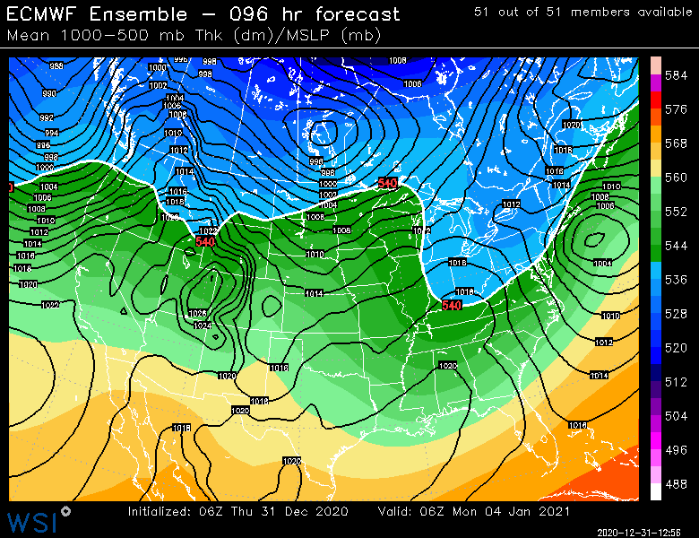
-
Significant upper middle Atlantic S/CNE mix/snow potential Jan 3+
ORH_wxman replied to Typhoon Tip's topic in New England
The 06z OP run has the vortmax further east too...it's going from near PIT into NE PA (and prob through SNE if we saw one more panel)....that is still Bruce Willis caution flags for the coast but it definitely brings interior SNE into play. Yesterday's 12z run was bringing that vort energy into ROC. The ULL itself is still pretty far west which leaves a reason to be cautious....but if we can start focusing that energy further SE like on that 06z run, then we'll have a shot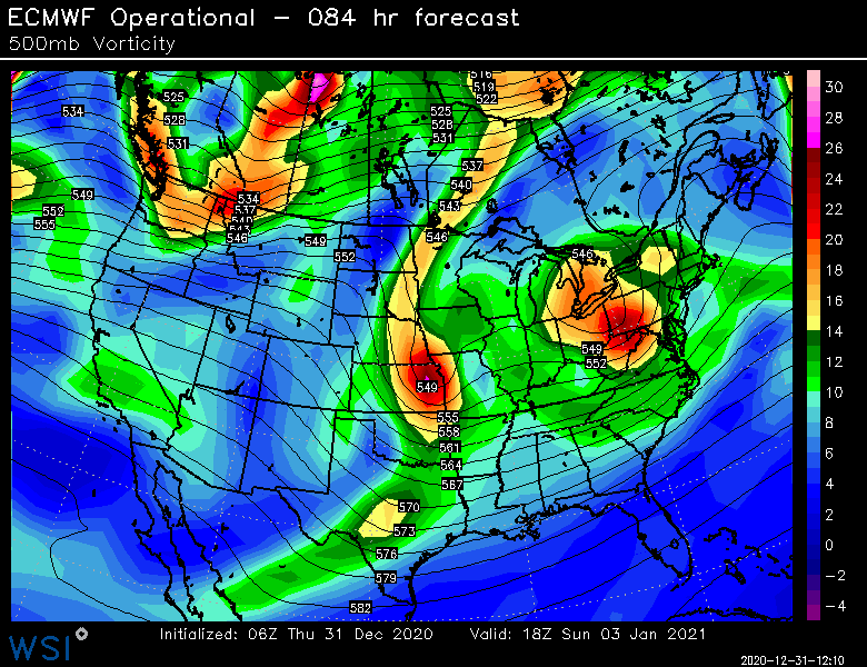
-
Significant upper middle Atlantic S/CNE mix/snow potential Jan 3+
ORH_wxman replied to Typhoon Tip's topic in New England
Yeah it was definitely better than the 00z run. The squeeze is on that run. -
Significant upper middle Atlantic S/CNE mix/snow potential Jan 3+
ORH_wxman replied to Typhoon Tip's topic in New England
Euro did come in a little colder than 12z. We’ll see if it can do it again on the 12z run today. Still have caution flags up on this one though. I’d like to see that shortwave get squeezed just a little more. -
Only a few weeks until Tip starts making posts about how warm the interior of his car feels after being parked in the sun all day.
-
Significant upper middle Atlantic S/CNE mix/snow potential Jan 3+
ORH_wxman replied to Typhoon Tip's topic in New England
Pretty good...still have caution flags for now but verbatim it’s a pretty good look for interior SNE up into NNE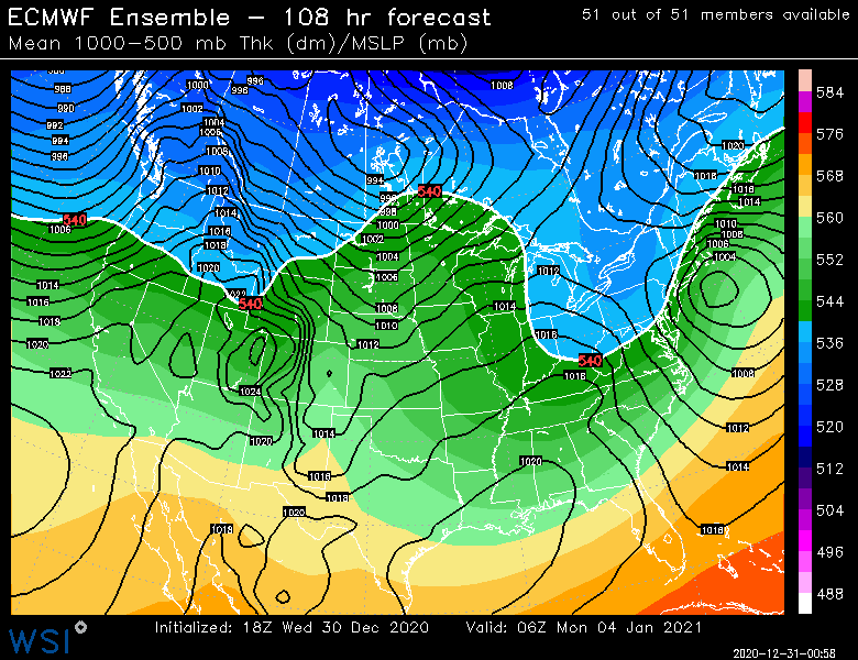
-
Significant upper middle Atlantic S/CNE mix/snow potential Jan 3+
ORH_wxman replied to Typhoon Tip's topic in New England
Hope 1/2 is slower to depart. It will help squeeze the ULL for 1/4 and give a legit chance to redevelop all the midlevels south of New England. -
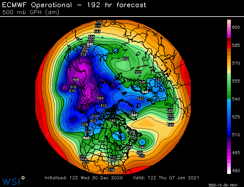
On a lot of runs the ridging kind of recycles and rebuilds at different times there rather than being this massive closed anticyclone. I wonder if that’s why the ensemble mean is more smoothed...because of the different timing of recycling ridges. Ideally, you’d have the closed anticyclone sitting right over the Davis Strait. There’s been a couple runs in clown range that have it but a lot of runs kind of look like the one I posted....where there’s a stout ridge there but it isn’t an immovable closed block...and it gets recycled a few times.
-
It would definitely be worrisome if we didn’t get an actual block...but the OP Euro has a legit Davis Strait block and so do several other models. When you see the ridging poking all the way back into northern Hudson Bay with the band of lower heights trapped underneath it, that’s what you are looking for....the lack of arctic air on our side of the pole makes it very marginal anyway for us, but without the block, we’d be in speedos and hammocks drinking pina coladas given how terrible the PAC is.
-
Dec (Edit: Jan1/..2 ) multi-faceted ptype mess potential...
ORH_wxman replied to Typhoon Tip's topic in New England
That is pretty snowy for pike northward on that RGEM run. 18z GFS render better for a inch or two on the front end as well for BOS/ORH. I’m still remaining mostly skeptical of the snow here for now until we get another tick colder. It’s not looking better up north of Rt 2 though for sure. -
Significant upper middle Atlantic S/CNE mix/snow potential Jan 3+
ORH_wxman replied to Typhoon Tip's topic in New England
FWIW, and prob not much yet, the 84h NAM at 18z is way slower in departing the 1/2 system which would definitely force the 1/4 system further south as the spacing between the two is smaller. -
Definitely a much more weenie-ish PAC at the end of the run.
-
Significant upper middle Atlantic S/CNE mix/snow potential Jan 3+
ORH_wxman replied to Typhoon Tip's topic in New England
There is still potential to get the 1/4 system (or even the one after that) into a "December 5th but slightly better airmass" territory, which would obviously work. It would require squeezing e ULL just underneath us though. I think even a Euro/GFS compromise might work on 1/4 for at least some of the area. -
Significant upper middle Atlantic S/CNE mix/snow potential Jan 3+
ORH_wxman replied to Typhoon Tip's topic in New England
I feel like anything we can grab before 1/10 is a bonus. 1/4 can definitely produce (esp interior), but there's not much wiggle room. There may be another shot around 1/7-9 or so. -
Significant upper middle Atlantic S/CNE mix/snow potential Jan 3+
ORH_wxman replied to Typhoon Tip's topic in New England
Want the lobe to redevelop sooner before the WAA taints everything. Ukie barely did this. GGEM was more successful. -
Significant upper middle Atlantic S/CNE mix/snow potential Jan 3+
ORH_wxman replied to Typhoon Tip's topic in New England
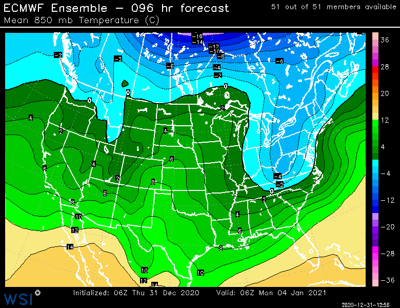
Yeah it could definitely come in more favorable....some large scale pieces are there for a good system as Tip already has outlined. But there are some details that can screw it up. Especially since we are dealing with such a marginal airmass. If we had a legit airmass in place...not even arctic...but like an antecedent airmass of, say, -6C 850, then it would be different and more wiggle room. The colder airmass also provides more resistance even aloft, so you promote redevelopment....it's a feedback of sorts. -
Significant upper middle Atlantic S/CNE mix/snow potential Jan 3+
ORH_wxman replied to Typhoon Tip's topic in New England
Btw, this is the same reason I was confident the Dec 16-17 wasn't going to be suppressed. Despite some of the Euro runs struggling to get the goods north of the pike, it had the vortmax tracking through east-central PA and LI/SE MA....that is not a suppressed look at all. So unless that part was wrong (which is less likely since models score higher on upper air features than sfc), it was going to come NW. This is just the same thing but further west than that. You have a potent vortmax/ULL swinging up into W NY and SE Canada. That is not a snowstorm look even into a chunk of CNE/NNE. Now, it could be wrong, or you get enough of a redevelopment lobe to the SE (Ukie tries to do this and GGEM does it even better), but there is reason to be cautious. -
Significant upper middle Atlantic S/CNE mix/snow potential Jan 3+
ORH_wxman replied to Typhoon Tip's topic in New England
Caution flags....upper level track is really far west, even on v16 GFS and Ukie. Now maybe we get a ULL track more like GGEM or regular GFS, but until the other guidance shows that is more likely, I have the alarm antennae up. -
Significant upper middle Atlantic S/CNE mix/snow potential Jan 3+
ORH_wxman replied to Typhoon Tip's topic in New England
Nah, it's lagging too much....baroclinicity already too far north for that 2nd shortwave to help. -
Significant upper middle Atlantic S/CNE mix/snow potential Jan 3+
ORH_wxman replied to Typhoon Tip's topic in New England
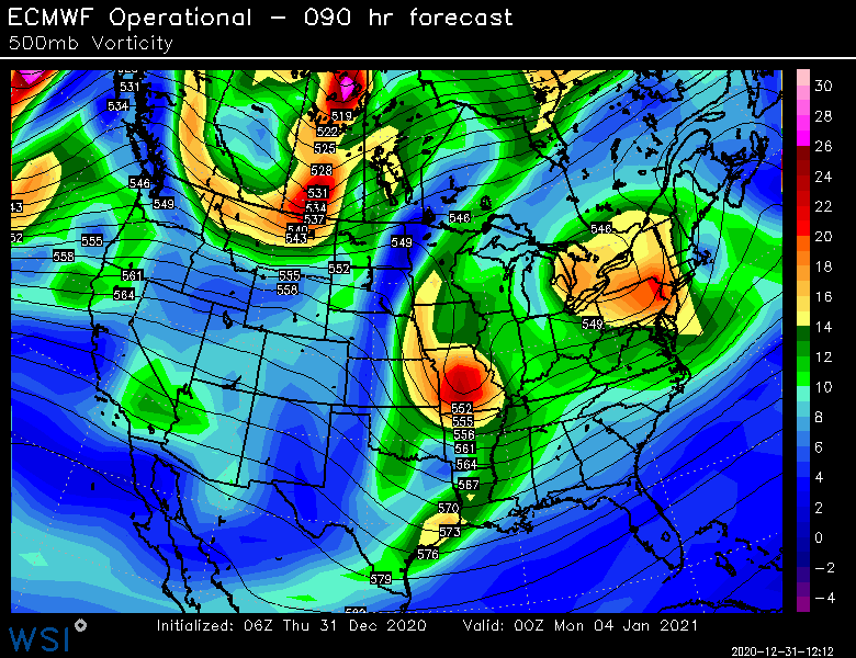
There's actually a weird follow-up vort behind the main one....see circled below....I wonder if that can help reorganize it further south.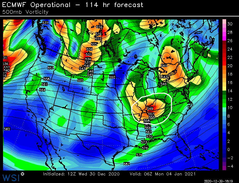
-
Significant upper middle Atlantic S/CNE mix/snow potential Jan 3+
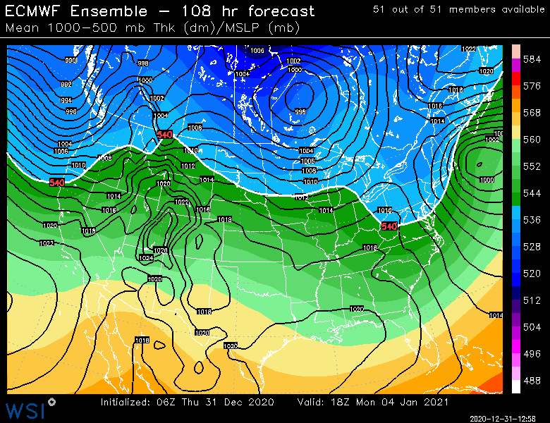
ORH_wxman replied to Typhoon Tip's topic in New England
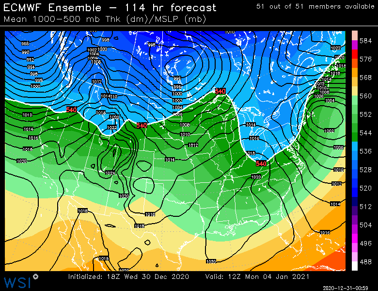
Euro looks like trash.....vortmax is over in ROC at 108h and H5 center is up near Lake Huron. Bruce Willis caution flags on this setup for sure.


