ORH_wxman
-
Posts
90,902 -
Joined
-
Last visited
Content Type
Profiles
Blogs
Forums
American Weather
Media Demo
Store
Gallery
Everything posted by ORH_wxman
-
Significant upper middle Atlantic S/CNE mix/snow potential Jan 3+
ORH_wxman replied to Typhoon Tip's topic in New England
18z EPS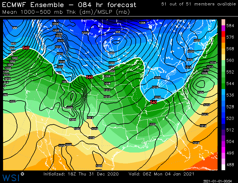
-
Never knew about the ethanol issues but I did notice my snow blower choking a bit last storm and was wondering if something was up with the motor. Ill have to try it from now on. There’s actually a gas station in town that sells ethanol-free gasoline.
-
Dec (Edit: Jan1/..2 ) multi-faceted ptype mess potential...
ORH_wxman replied to Typhoon Tip's topic in New England
The WCB on this one has looked kind of sickly on most runs. Not seeing that clean thump look. I think 6+ is going to have to be where CCB actions gets involved (not counting the upslope spots). -
Significant upper middle Atlantic S/CNE mix/snow potential Jan 3+
ORH_wxman replied to Typhoon Tip's topic in New England
18z euro is weak sauce way southeast. -
Wow what a weenie run of the weeklies. 2nd half of January is all teed up on that look.
-
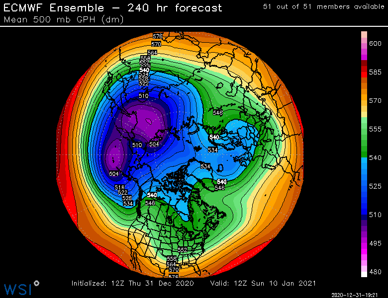
Many of the members must be breaking off a piece of the PV like the OP. I noticed the heights down in Ontario and our region look lower than previously. That’s obviously a good thing....even a little bit of fresh airmass enhancement goes a long ways when you have a block like that. A little more antecedent air can give a lot more wiggle room. Hopefully we see that trend stay on future runs.
-
Yeah plenty of ant-cyclonic curve on that
-
Significant upper middle Atlantic S/CNE mix/snow potential Jan 3+
ORH_wxman replied to Typhoon Tip's topic in New England
EPS looks a bit NW of the OP run. -
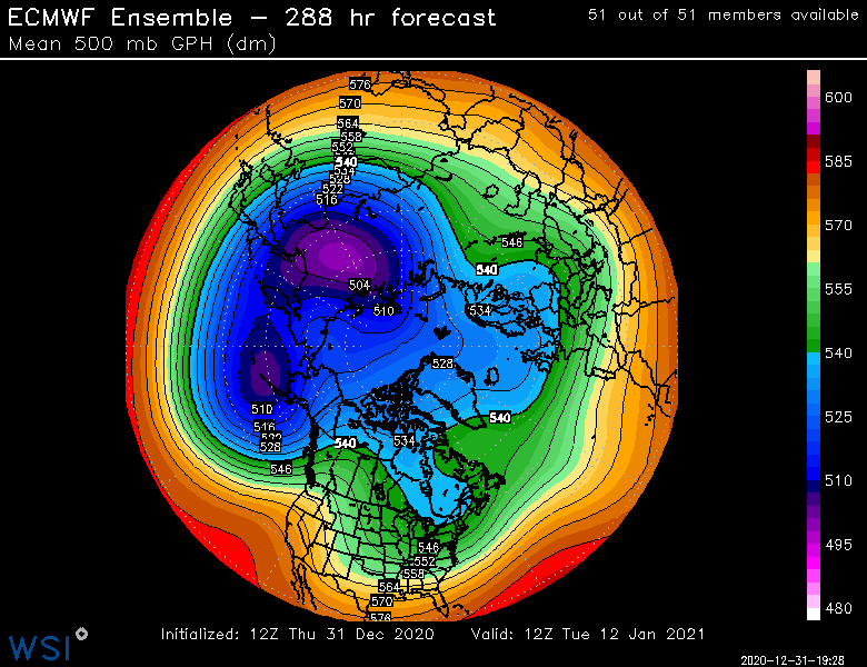
Yes. We did have a shorter lived block in Jan 2016 but it never got as intense as current model guidance is suggesting this one could be.
-
Did you see how this run breaks off a little piece of the PV around D4-5 and that actually then gets trapped in S Canada and keeps some decent cold around? You can see it sitting there just SE of Hudson Bay on the map I posted.
-
Significant upper middle Atlantic S/CNE mix/snow potential Jan 3+
ORH_wxman replied to Typhoon Tip's topic in New England
dryslot was hanging out with ice1972 this morning -
Davis Strait block....
-
Significant upper middle Atlantic S/CNE mix/snow potential Jan 3+
ORH_wxman replied to Typhoon Tip's topic in New England
What in the hell is the Euro doing? It's trying to pull a Feb '69 and retrograde it back. Doesn't succeed, but it makes an attempt. -
Significant upper middle Atlantic S/CNE mix/snow potential Jan 3+
ORH_wxman replied to Typhoon Tip's topic in New England
Vort is pretty weak sauce, but it's still tracking into SE NY....so that is still a caution flag for believing a far SE solution. -
Significant upper middle Atlantic S/CNE mix/snow potential Jan 3+
ORH_wxman replied to Typhoon Tip's topic in New England
12z Euro is going to squeeze the s/w more this run I think. The 1/2 system continues to be slower departing than 06z run. -
Significant upper middle Atlantic S/CNE mix/snow potential Jan 3+
ORH_wxman replied to Typhoon Tip's topic in New England
Ukie is mostly a whiff...it gives some snow to CT and MA....it shows rain for SE MA, but I think it would prob be snow as they get into a commahead for a time. But it has sfc temps around 37 so it spits out rain on the clown maps....but 850 temp is like -5 and 925mb is like -1 to -2 so I would say snow there. Doesn't really matter though on a 96h prog. -
Significant upper middle Atlantic S/CNE mix/snow potential Jan 3+
ORH_wxman replied to Typhoon Tip's topic in New England
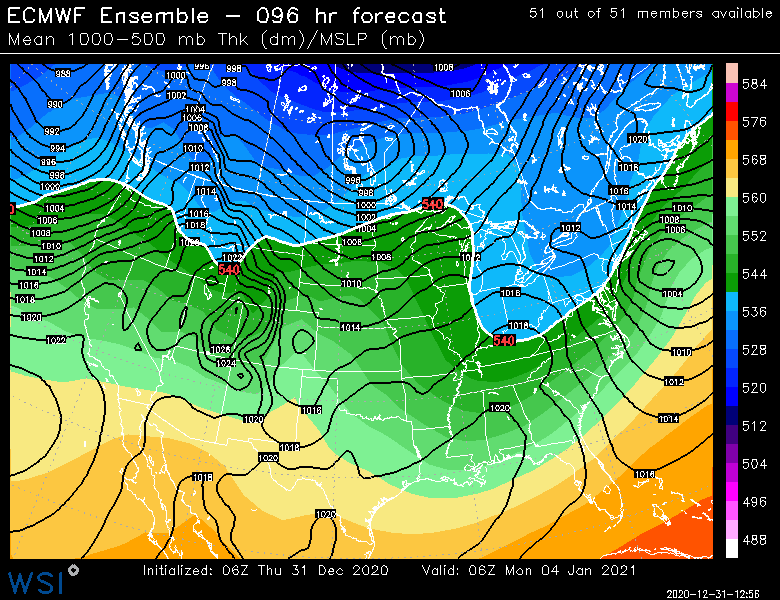
Why the hell are we posting an 84 hour map in this thread when the event is basically starting in SNE at 78-84 hours? -
At least wait until afternoon to hit the egg nog today. It's a long night.
-
Significant upper middle Atlantic S/CNE mix/snow potential Jan 3+
ORH_wxman replied to Typhoon Tip's topic in New England
Yeah, title says 3+....guess it could just say 3-4, though ti could linger into Maine until 1/5. It likely starts in SNE on the 3rd. -
Significant upper middle Atlantic S/CNE mix/snow potential Jan 3+
ORH_wxman replied to Typhoon Tip's topic in New England
Yeah it kind of reaches up to ACY latitude and then goes straight east....reminds me a bit of some of those squashed runs from Dec 16-17. -
Significant upper middle Atlantic S/CNE mix/snow potential Jan 3+
ORH_wxman replied to Typhoon Tip's topic in New England
Ukie is way SE....a bit of model chaos.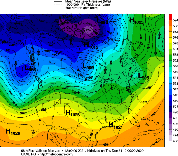
-
Significant upper middle Atlantic S/CNE mix/snow potential Jan 3+
ORH_wxman replied to Typhoon Tip's topic in New England
Yeah get that just a little further SE....the trend is our friend though on the shortwave squeeze. -
Significant upper middle Atlantic S/CNE mix/snow potential Jan 3+
ORH_wxman replied to Typhoon Tip's topic in New England
GGEM came southeast from 00z....more like a berks to dendrite crusher though verbatim. -
Significant upper middle Atlantic S/CNE mix/snow potential Jan 3+
ORH_wxman replied to Typhoon Tip's topic in New England
Vort energy actually gets forced underneath SNE that run....which is why it was really good. -
Significant upper middle Atlantic S/CNE mix/snow potential Jan 3+
ORH_wxman replied to Typhoon Tip's topic in New England
Yeah....and while the high is kind of weak, it is at least there feeding the dry dewpoints into the system to help with evap cooling. Compare this one: With this one (12/5):