

ORH_wxman
-
Posts
90,902 -
Joined
-
Last visited
Content Type
Profiles
Blogs
Forums
American Weather
Media Demo
Store
Gallery
Everything posted by ORH_wxman
-
Significant upper middle Atlantic S/CNE mix/snow potential Jan 3+
ORH_wxman replied to Typhoon Tip's topic in New England
RGEM is actually going to capture it in a good spot for eastern spots...a little different than the NAM. -
Significant upper middle Atlantic S/CNE mix/snow potential Jan 3+
ORH_wxman replied to Typhoon Tip's topic in New England
RGEM not as amped as 12z so far...which isn't terribly surprising since it was one of the most amped models at 12z -
Dec (Edit: Jan1/..2 ) multi-faceted ptype mess potential...
ORH_wxman replied to Typhoon Tip's topic in New England
Cold layer below the warm tongue is pretty deep for the first several hours, so I wouldn't be surprised at a pretty good sleet-fest for a time. Esp in the zone between the pike and N CT/N RI. -
Significant upper middle Atlantic S/CNE mix/snow potential Jan 3+
ORH_wxman replied to Typhoon Tip's topic in New England
You're in a decent spot. -
Significant upper middle Atlantic S/CNE mix/snow potential Jan 3+
ORH_wxman replied to Typhoon Tip's topic in New England
You'd get like a foot-plus? What's wrong with that -
Significant upper middle Atlantic S/CNE mix/snow potential Jan 3+
ORH_wxman replied to Typhoon Tip's topic in New England
A lot of parallels with the first Feb '83 storm (the one before the HECS)....Feb 6-7, 1983. That was a huge crush job from roughly 495 belt westward and northwest. Though it did bring some decent snows to 128 (albeit some taint) -
Significant upper middle Atlantic S/CNE mix/snow potential Jan 3+
ORH_wxman replied to Typhoon Tip's topic in New England
Actually looks a lot like the Feb 5, 2001 snowfall distribution -
Significant upper middle Atlantic S/CNE mix/snow potential Jan 3+
ORH_wxman replied to Typhoon Tip's topic in New England
You could see it early on that it would likely be good. That shortwave gets squeezed and slows everything down and allows the sfc to feed off the upper air better. It also squashes the vortmax south of SNE which is a more potent look for coastals. -
Significant upper middle Atlantic S/CNE mix/snow potential Jan 3+
ORH_wxman replied to Typhoon Tip's topic in New England
18z NAM is coming in slower through 48....which is probably a good thing for a better system on 1/3-1/4 -
Significant upper middle Atlantic S/CNE mix/snow potential Jan 3+
ORH_wxman replied to Typhoon Tip's topic in New England
-
Significant upper middle Atlantic S/CNE mix/snow potential Jan 3+
ORH_wxman replied to Typhoon Tip's topic in New England
That was the best H5 track we've seen on the Euro....that would prob be better for SNE (esp EASTERN AREAS!!!) than shown. I agree the crazy capture and stall is likely happening to our northeast though. I don't expect 20-30" for anyone until maybe you get up into DE ME. -
Dec (Edit: Jan1/..2 ) multi-faceted ptype mess potential...
ORH_wxman replied to Typhoon Tip's topic in New England
It was a late phase but the whole thing was much further southeast....and t ended up creating like a 700-800 mile firehose in the mid levels coming out of the east. Had 23 inches in that one in ORH. This one if it does phase and stall would happen much further north...it wouldn’t be an easterly firehose setup. It would be a rotting CCB/deformation. -
Significant upper middle Atlantic S/CNE mix/snow potential Jan 3+
ORH_wxman replied to Typhoon Tip's topic in New England
Eh maybe not. 84h 06z was pretty good. I thought it looked better than 06z leading up to that timeframe though. -
Significant upper middle Atlantic S/CNE mix/snow potential Jan 3+
ORH_wxman replied to Typhoon Tip's topic in New England
Almost captured this run. Better than 06z at least. -
Significant upper middle Atlantic S/CNE mix/snow potential Jan 3+
ORH_wxman replied to Typhoon Tip's topic in New England
This isn’t fast flow anyway. -
Dec (Edit: Jan1/..2 ) multi-faceted ptype mess potential...
ORH_wxman replied to Typhoon Tip's topic in New England
Could be a nice little sleet bomb for 3 hours here. Hopefully it starts as a couple hours of snow to at least whiten everything up good. -
Significant upper middle Atlantic S/CNE mix/snow potential Jan 3+
ORH_wxman replied to Typhoon Tip's topic in New England
Yes. I don’t disagree with that. Even on scenarios where the ULL is redeveloping almost overhead, interior SNE will get accumulating snow. Perhaps even a decent amount. But it won’t be the favored spot for the heaviest and longest duration snows. That would be favored further northeast in that scenario. So I think that’s the difference between and advisory type event or something much bigger. -
Significant upper middle Atlantic S/CNE mix/snow potential Jan 3+
ORH_wxman replied to Typhoon Tip's topic in New England
Need to see that from more guidance. A lot of guidance has the ULL trying to go almost overhead which is more of an NNE look. -
Significant upper middle Atlantic S/CNE mix/snow potential Jan 3+
ORH_wxman replied to Typhoon Tip's topic in New England
Ukie is a pretty big hit too for SNE and especially Maine. This whole capture and stall scenario is really a theme tonight though I’m not really buying it outside of Maine until we get closer. Those capture/stall for 24 hour scenarios tend to drift more progressive as we get closer historically on model guidance. -
Significant upper middle Atlantic S/CNE mix/snow potential Jan 3+
ORH_wxman replied to Typhoon Tip's topic in New England
And the entire time the ensembles were northwest of those suppressed euro runs...not to mention the Synoptics (vortmax and ULL) argued for a track NW of those OP runs. -
Significant upper middle Atlantic S/CNE mix/snow potential Jan 3+
ORH_wxman replied to Typhoon Tip's topic in New England
Never totally sure in meteorology....especially at this time range...but I haven’t seen a thing so far at 00z to make me think otherwise. I’m not worried about a whiff. -
Significant upper middle Atlantic S/CNE mix/snow potential Jan 3+
ORH_wxman replied to Typhoon Tip's topic in New England
He will probably say lop off the first 20 inches because the ground is warm. -
Significant upper middle Atlantic S/CNE mix/snow potential Jan 3+
ORH_wxman replied to Typhoon Tip's topic in New England
Yep, my bigger worry in central MA is ptype versus a SE track until there’s some major evidence for otherwise. -
Significant upper middle Atlantic S/CNE mix/snow potential Jan 3+
ORH_wxman replied to Typhoon Tip's topic in New England
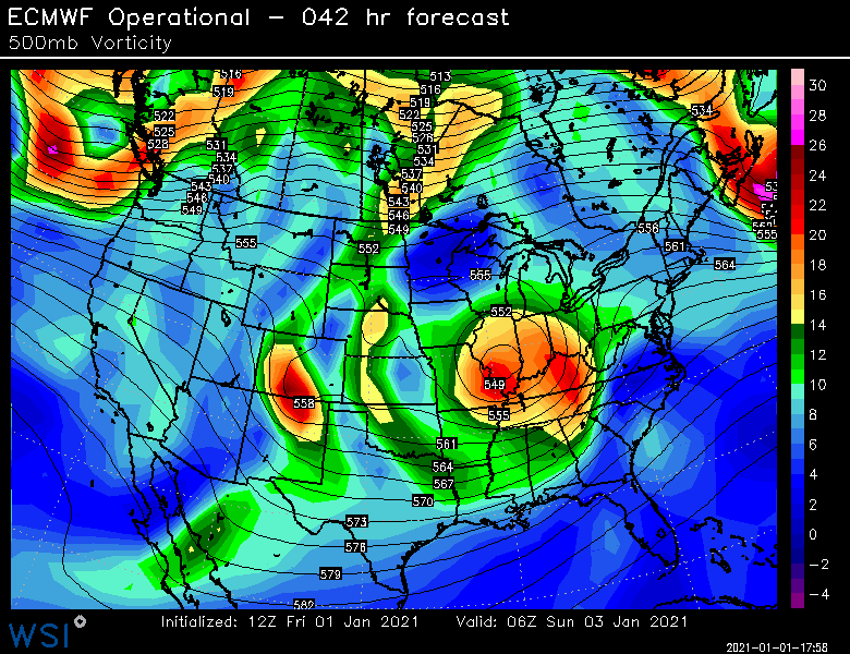
ULL and vortmax track for those worrying about a SE track...... -
I won’t hate on Forky for the snowblower comment...I used to think the exact same way but then I bought a house that happened to have a wrap around driveway...on a curve in the road (so the snowbanks get obscene)...LOL. Just brutal shoveling that. I did it the first winter in this house including 3 storms of 12”+ (1/4/18, 3/7-8/18, 3/13/18)...after that I said “never again”.


