

ORH_wxman
-
Posts
90,902 -
Joined
-
Last visited
Content Type
Profiles
Blogs
Forums
American Weather
Media Demo
Store
Gallery
Everything posted by ORH_wxman
-
1/19-20/78....not even sure I’d qualify it as “widespread” 20 inches but BOS had 21.4 I think. It was their biggest snowfall on record at the time...a record that would last about 2 weeks.
-
Significant upper middle Atlantic S/CNE mix/snow potential Jan 3+
ORH_wxman replied to Typhoon Tip's topic in New England
Yeah the drought is getting bad there. They could use another 3 or 4 inches of downpours. -
I mean, there aren’t many January 20+ widespread events anyway in our region. They seem to be more common in Feb/Mar. Like for SNE, it’s really only 2015, 2011, 2005, 1996, 1978, 1961...maybe one more I’m forgetting? Don’t think ‘87 had a widespread 20 incher though the 1/2/87 storm had some pockets.
-
Significant upper middle Atlantic S/CNE mix/snow potential Jan 3+
ORH_wxman replied to Typhoon Tip's topic in New England
I think areas E of 128/95 will really need the rates too. The lower levels there are more marginal than further west. -
Significant upper middle Atlantic S/CNE mix/snow potential Jan 3+
ORH_wxman replied to Typhoon Tip's topic in New England
Honestly, the midlevels look like they hit E MA/RI even harder than qpf distribution would suggest. That’s a good look there. Well see if more guidance comes on board at 00z. -
Significant upper middle Atlantic S/CNE mix/snow potential Jan 3+
ORH_wxman replied to Typhoon Tip's topic in New England
18z euro still looks good for solid advisory. Might have been a tick closer with the good CCB in E MA. That’s almost a huge hit. -
It was colder than our airmasses for the next week but i don’t think I’d qualify it as arctic. It was like -5C 850 antecedent. I don’t remember it being in the teens in that one. Maybe like mid 20s on the cold side of the CF.
-
1/12/11 off the top of my head. Prob not many others.
-
Significant upper middle Atlantic S/CNE mix/snow potential Jan 3+
ORH_wxman replied to Typhoon Tip's topic in New England
There were definitely some zonked GFS and GEM runs in there a couple days ago...giving all different parts of SNE 12”+ (in some cases way more) depending on which run it was....but those all had a clear capture and stall down at a further south latitude which was never totally realistic imho. I’m still thinking the precip shield will be further northwest though on the initial burst than modeled for reasons discussed already many times. We’ll see if that improves on tonight’s 00z runs. -
Significant upper middle Atlantic S/CNE mix/snow potential Jan 3+
ORH_wxman replied to Typhoon Tip's topic in New England
Yeah I actually thought the EPS was one of the better pieces of guidance all day. That said, I’d be lying if I said some of these paltry outputs like the NAM weren’t concerning. -
Significant upper middle Atlantic S/CNE mix/snow potential Jan 3+
ORH_wxman replied to Typhoon Tip's topic in New England
My gut says it prob tickles down to 29-30 I think at elevation later Sunday/Sunday night. It will prob start near freezing Sunday afternoon though. 925s are like -2 or -3 and we have that weak high to the north so I think it will be hard to stay near 32 in elevated interior when steady snow is falling. Esp after dark. -
Significant upper middle Atlantic S/CNE mix/snow potential Jan 3+
ORH_wxman replied to Typhoon Tip's topic in New England
Looks like there may be a CF pretty close to BOS-PVD line for at least a while. Maybe just NW of that. Should be below freezing on the west side of that overnight Sunday night. SE MA could struggle at 34 unless rates are higher...which they could be. -
Significant upper middle Atlantic S/CNE mix/snow potential Jan 3+
ORH_wxman replied to Typhoon Tip's topic in New England
Tick tick tick... -
Significant upper middle Atlantic S/CNE mix/snow potential Jan 3+
ORH_wxman replied to Typhoon Tip's topic in New England
Seriously...I remember like 5 days saying that anything before the first 8-10 days of January ends is gravy....lol. Now we might have two systems to follow. -
Significant upper middle Atlantic S/CNE mix/snow potential Jan 3+
ORH_wxman replied to Typhoon Tip's topic in New England
Yeah I like the upper level track and would be surprised if there isn’t more qpf to the northwest of what is currently shown. Like I said before, maybe I’m wrong this time. It wouldn’t be the first time and certainly not the last, but just based on the core of the vort track and ULL, you’d expect more precip blossoming on that NW side than models are spitting out. -
Significant upper middle Atlantic S/CNE mix/snow potential Jan 3+
ORH_wxman replied to Typhoon Tip's topic in New England
You need it to track south of SNE which it doesn’t on a lot of runs. Almost goes overhead more than anything. -
Significant upper middle Atlantic S/CNE mix/snow potential Jan 3+
ORH_wxman replied to Typhoon Tip's topic in New England
Im not sure how much 6+ this will have in SNE. Might be a lot more 3-5ish if we can’t tuck in the baroclinic zone tighter. We’ll see how the next 12 hours trends though. -
Significant upper middle Atlantic S/CNE mix/snow potential Jan 3+
ORH_wxman replied to Typhoon Tip's topic in New England
This isn’t far from what I think might happen. Kind of a broad brush advisory snowfall. Wouldn’t surprise me though to see a stripe of warning snow where some of the residual midlevel support is. -
Perfect base builder
-
Significant upper middle Atlantic S/CNE mix/snow potential Jan 3+
ORH_wxman replied to Typhoon Tip's topic in New England
Difference is likely a lot more to come for eastern areas whereas euro was done after the initial shot. That hrrr run was starting to slow and back in from the east with the potent CCB. -
Significant upper middle Atlantic S/CNE mix/snow potential Jan 3+
ORH_wxman replied to Typhoon Tip's topic in New England
I don’t think that part of the storm is going to hit SNE. It’s going to be the initial thump from the main vortmax that is pretty far west...that’s the part id expect to look better as we get closer. The ferocious CCB and stall is likely going to stay offshore though maybe eastern areas still get lucky. -
Agreed.
-
Significant upper middle Atlantic S/CNE mix/snow potential Jan 3+
ORH_wxman replied to Typhoon Tip's topic in New England
Rhode Islanders lock in the RPM? Revenge for 3/7-8/13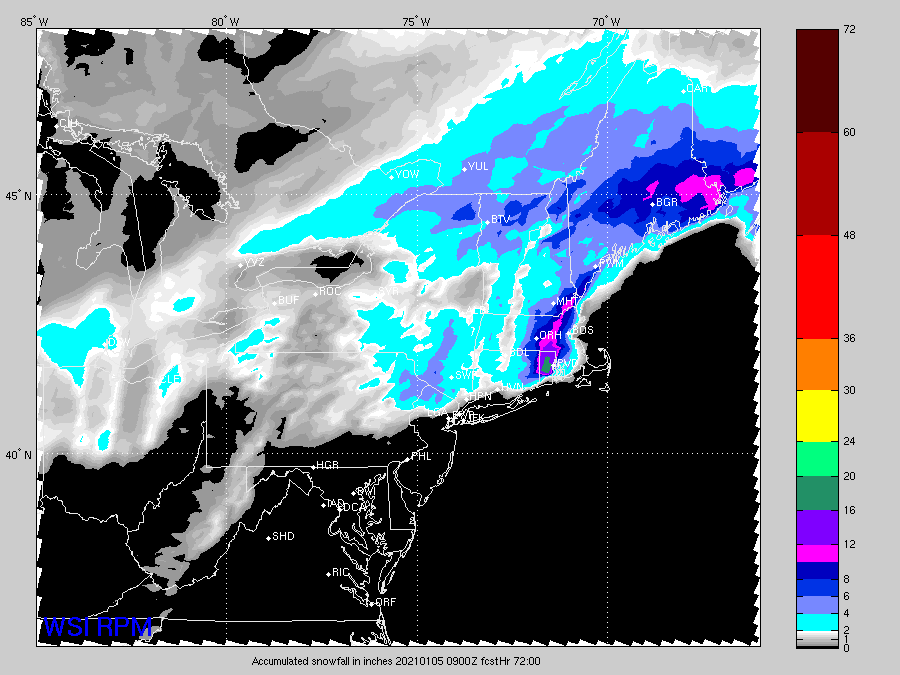
-
Significant upper middle Atlantic S/CNE mix/snow potential Jan 3+
ORH_wxman replied to Typhoon Tip's topic in New England
I’d expect the sfc low to slowly become a bit more tucked even if the upper air stays the same. That’s what I was saying before. Same reason we saw those suppressed runs start disappearing on the dec 16-17 threat late in the game (and they still weren’t far enough north...except some of those rgem/GGEM runs) What I’m explaining is different than the actual stall. I’m just expecting a closer track than most guidance shows right now, but I’m guessing the stall doesn’t happen until into the Gulf of Maine. We’ve actually seen the stall trend further northeast with time as is usually the case. It’s still possible it could happen far enough southwest to impact E MA/E NH/far S ME so it’s worth watching but my guess is that the stall really only matters for Downeast. -
Significant upper middle Atlantic S/CNE mix/snow potential Jan 3+
ORH_wxman replied to Typhoon Tip's topic in New England
Keeps ticking NW each run with the main sfc features.


