ORH_wxman
-
Posts
90,902 -
Joined
-
Last visited
Content Type
Profiles
Blogs
Forums
American Weather
Media Demo
Store
Gallery
Everything posted by ORH_wxman
-
NAM def a lot better now for the NNE interior peeps.
-
A lot of guidance has the midlevels too warm out in the Berkshires and NW CT. So you have to reconcile that difference before going gung ho. It’s not a situation where one model is like 0C and another is +1C at 925 with 850s of -2C. It’s legit like 850 temps being +2 on some guidance and near 0C on others.
-
Not to nitpick, but 2011 would be more like 50-70" in 4 weeks....I ripped off 63 inches between 1/7 and 2/2 in 2011. 30-40 would be more like a Feb '14 or a Jan '94 run. Nothing to sneeze at obviously...I'd take it and run.
-
Yeah the anomaly difference is like 3-4C and the stratospheric PV is squashed/elongated more on the recent runs. Yeah gonna be hard to get a KU type system in this pattern I think....if there's a window though, I'd prob pick late January when the trough retrogrades into the GOA and may provide a little bit of temporary ridging into the Rockies while we still have a good Atlantic in place. Maybe something like going on an early 1994 run is definitely viable though.
-
Yeah that is much better looking than Monday. NAO exerting more influence. Hopefully the break down of the blocking keeps getting pushed out.....you'd expect that to be a theme as guidance starts to "see" the SSW better as it downwells.
-
I was just thinking of that storm when I saw the Euro....reminded me of 2/2/15.
-
Yeah it does look pretty damned cold for a while. Hopefully we can lay down some snow. Nothing worse than frigid cold with bare frozen ground.
-
Convenient how the hadley cell signature of above average heights in the subtropical latitude band over the southern CONUS was nowhere to be found the first two weeks of the month when we needed it most
-
Steady light snow has commenced here.
-
Where did you get that idea?
-
Yep and it wasn't that far from being snow...when we need a block to hold the line just a little longer, it doesn't on the 1/16-1/17 system. Frustrating. But that's how it goes. This past couple weeks wasn't a textbook snow pattern, but it was serviceable. It was one of those rare "mild but potentially snowy" blocky patterns. Late Dec 2012 was kind of like that but we managed a couple good events (at least away from water).
-
This is a microcosm of January so far....long wave setup is decent, but can't buy a scenario where the shortwaves cooperate. You have a robust shortwave (even closed off) in the midwest but it can't do shit for us because it's too close to the 1/17 system.
-
Carbon copy of January 2013 and 2015. The bitching is always worse when the pattern isn't garbage but we're still not getting the snowstorms.
-
Good candidate for a 5-post
-
You don’t enjoy the semantical debate on whether we should call it “unpredictable shortwave chaos” or “luck”?
-
Who guaranteed snowstorms? It should be common knowledge for someone like you that has been on the boards for 15+ years that good patterns don’t guarantee snowstorms. But we’re not going to pretend the chances are the same in a good pattern vs a garbage one either. It’s ok to talk about potential.
-
You aren’t being a realist. You are doing exactly what you did in 2013. You even kept pretending that the Feb ‘13 blizzard threat was going to miss until it became really obvious like 60-72 hours out. It’s possible we keep whiffing in the upcoming pattern, but it has nothing to do with what happened earlier in the month.
-
Just close the shades man. We’ll see you in March.
-
We will be longing for the days of early January 2021 once the hadley cell destroys our geopotential medium later this month.
-
No worries, northern hemisphere is usually good.
-
Hopefully they can zoom it out even more on future updates. Maybe we can simulate the view from the moon.
-
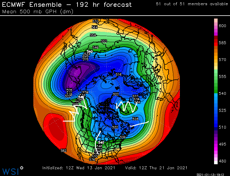
squiggly lines are ridges and straighter lines are the troughs....that's all.
-
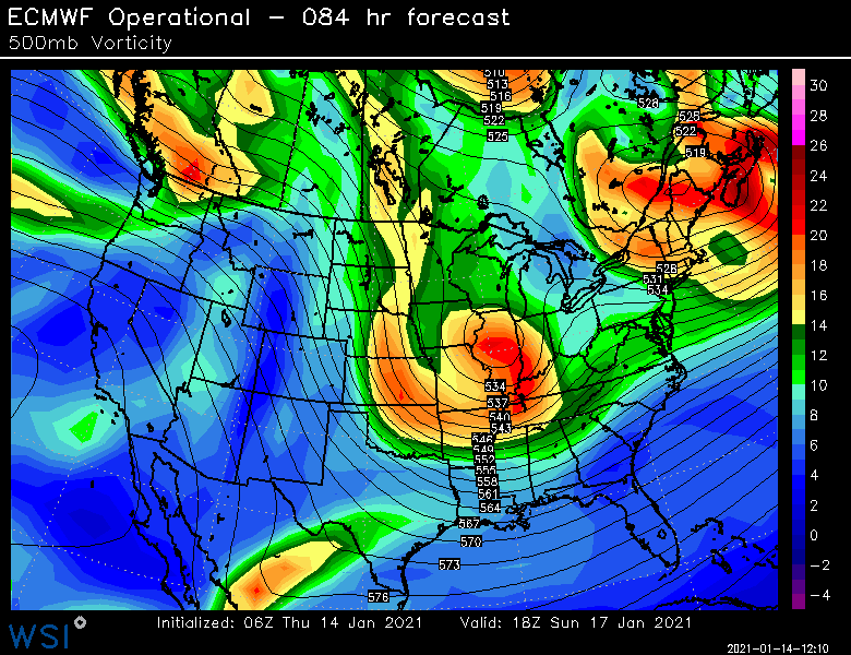
They are directly related....NAO block holds the 50/50 low in place. I can see his point on the upstream ridging potential....it's definitely not a classic KU setup. We don't have a rockies/western ridge. This is more of a SWFE type threat running into a brick wall. Those can be very good of course....but they have a different mechanics behind them than the classic maturing coastal cyclone. Yep...as mentioned above, this is kind of a SWFE on steroids look....prob would be a cutter without that block.
-
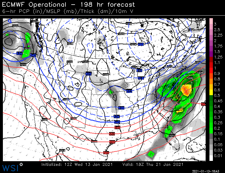
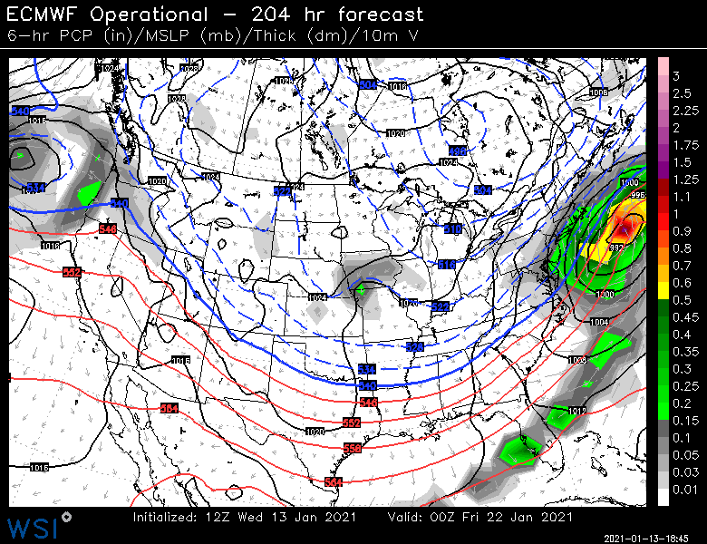
EPS is a pretty strong look for 1/21-1/22...prob our best synoptic look since the Dec 17 threat. We'll see if it sticks.
-
It's plenty cold...in fact, prob too much cold this run.